Nong Khai Province
| Nong Khai หนองคาย | ||
|---|---|---|
| Province | ||
| ||
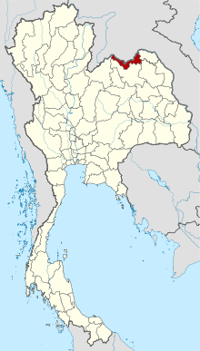 Map of Thailand highlighting Nong Khai Province | ||
| Country |
| |
| Capital | Nong Khai | |
| Government | ||
| • Governor | Suchat Nopphawan (since November 2014) | |
| Area | ||
| • Total | 3,027 km2 (1,169 sq mi) | |
| Area rank | Ranked 27th | |
| Population (2014) | ||
| • Total | 517,269[1] | |
| • Rank | Ranked 22nd | |
| • Density rank | Ranked 37th | |
| Time zone | ICT (UTC+7) | |
| ISO 3166 code | TH-43 | |

Nong Khai (Thai: หนองคาย, pronounced [nɔ̌ːŋ kʰāːj]) is the northernmost of the northeastern (Isan) provinces (changwat) of Thailand. Neighbouring provinces are (from east clockwise) Bueng Kan, Sakon Nakhon, Udon Thani, and Loei. To the north it borders Vientiane Province, Vientiane Prefecture, and Bolikhamxai of Laos.
Geography
The province is in the valley of the Mae Nam Kong (Mekong River), which also forms the border with Laos. There are highlands to the south. The Laotian capital Vientiane is only 25 kilometres away from the provincial capital of Nong Khai. The Thai-Lao Friendship Bridge, which connects the two countries, was built jointly by the governments of Thailand, Laos, and Australia, and was opened in 1994.[2]
History
Over the centuries the control of the province swung between the Thai Kingdom Ayutthaya, and the Laotian kingdom Lan Xang, as their respective powers ebbed and flowed in the region.[3] See also the Haw wars.
Symbols
| The provincial seal shows a pond with a bamboo clump close to it. The bamboo symbolizes stability, glory, and continuity for the peaceful and fertile land.[4]
The provincial tree is the tamalan or Burma pallisander (Dalbergia oliveri). |
Administrative divisions
As of March 23, 2011, the province is subdivided into nine districts (amphoe). The districts are further subdivided into 62 subdistricts (tambon) and 705 villages (muban). The eight districts of Bueng Kan were districts of Nong Khai before, they were split as the newest province of Thailand.
|
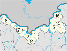 Map of amphoe |
References
- ↑ "Population of the Kingdom" (PDF). Department of Provincial Affairs (DOPA) Thailand (in Thai). 2014-12-31. Retrieved 19 Mar 2015.
- ↑ "Thai-Lao Friendship Bridge". Tourism Authority of Thailand (TAT). Retrieved 22 May 2015.
- ↑ "Nong Khai". Tourism Authority of Thailand (TAT). Retrieved 22 May 2015.
- ↑ Masure, Yves. "Nong Khai". THAILEX Travel Encyclopedia. Retrieved 22 May 2015.
External links
 Nong Khai travel guide from Wikivoyage
- Provincial website (Thai)
 |
Vientiane Capital, |
Bolikhamsai Province, |
| |
| Loei Province | |
Bueng Kan Province | ||
| ||||
| | ||||
| Udon Thani Province | Sakon Nakhon Province |
Coordinates: 17°52′5″N 102°44′40″E / 17.86806°N 102.74444°E