Noen Kum
| Noen Kum เนินกุ่ม | |
|---|---|
| Tambon | |
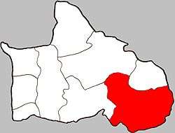 Location of Noen Kum within Amphoe | |
| Coordinates: 16°33′00″N 100°25′00″E / 16.55000°N 100.41667°ECoordinates: 16°33′00″N 100°25′00″E / 16.55000°N 100.41667°E | |
| Country | Thailand |
| Province | Phitsanulok |
| Amphoe | Bang Krathum |
| Elevation | 38 m (125 ft) |
| Population (2005) | |
| • Total | 8,838 |
| Time zone | Thailand (UTC+7) |
| Postal code | 65110 |
| Geocode | 650508 |
| Chief roadway | Route 11 |
| Chief watercourse | Wat Ta Yom River |
Noen Kum (Thai: เนินกุ่ม) is a subdistrict (tambon) in the Bang Krathum district of Phitsanulok Province, Thailand.
Geography
Noen Kum borders Wat Ta Yom to the north, Amphoe Wang Thong to the north-east, Phichit Province to the south and south-east, Phai Lom to the west and Nakhon Pa Mak to the north-west.
Noen Kum lies within the Nan Basin, which is part of the Chao Phraya Watershed. The Wat Ta Yom River flows through Noen Kum.
Administration
The subdistrict is subdivided into 11 smaller divisions called (muban), which roughly correspond to the villages in Noen Kum. There are 7 villages, several of which occupy multiple muban. Noen Kum is administrated by a Tambon administrative organization (TAO). The muban in Noen Kum are enumerated as follows: [1]
| No. | English | Thai |
| 1 | Ban Tha Yang | บ้านท่ายาง |
| 2 | Ban Nong Payayo | บ้านหนองพญายอ |
| 3-6 | Ban Noen Kum | บ้านเนินกุ่ม |
| 7-8 | Ban Dongmee | บ้านดงหมี |
| 9 | Ban Nong Grot | บ้านหนองกรด |
| 10 | Ban Tha Hae | บ้านท่าแห |
| 11 | Ban Wat Mai Prai Manee | บ้านวัดใหม่ไพรมณี |
Economy
The economy of Noen Kum is almost entirely based on rice farming and other agriculture.[2]
Temples
Noen Kum is home to the following seven temples:[3]
- Wat Dongmee (Dongmee Village Temple) in Ban Dongmee
- Wat Noen Kum (Noen Kum Village Temple) in Ban Noen Kum
- วัดราษฎร์ศรัทธาราม in Ban Noen Kum
- Wat Sa Settee (Thai: วัดสระเศรษฐี, Wealthy Man's Pond Temple) in Ban Tha Yang
- วัดราษฎร์สถิต in Ban Nong Grot
- Wat Mai Prai Manee in Ban Wat Mai Prai Manee
- Wat Nong Grot (Nong Grot Villate Temple) in Ban Nong Grot