Nisyros
| Nisyros Νίσυρος | |
|---|---|
|
VIew of Mandraki | |
 Nisyros | |
|
Location within the region  | |
| Coordinates: 36°35′N 27°10′E / 36.583°N 27.167°ECoordinates: 36°35′N 27°10′E / 36.583°N 27.167°E | |
| Country | Greece |
| Administrative region | South Aegean |
| Regional unit | Kos |
| Area | |
| • Municipality | 50.06 km2 (19.33 sq mi) |
| Highest elevation | 698 m (2,290 ft) |
| Lowest elevation | 0 m (0 ft) |
| Population (2011)[1] | |
| • Municipality | 1,008 |
| • Municipality density | 20/km2 (52/sq mi) |
| Time zone | EET (UTC+2) |
| • Summer (DST) | EEST (UTC+3) |
| Postal code | 853 03 |
| Area code(s) | 22420 |
| Vehicle registration | ΚΧ, ΡΟ, ΡΚ |
| Website | www.nisyros.gr |

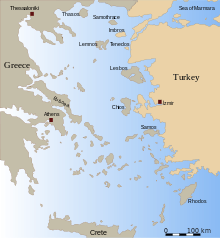
Nisyros (Greek: Νίσυρος) is a volcanic Greek island and municipality located in the Aegean Sea. It is part of the Dodecanese group of islands, situated between the islands of Kos and Tilos.
Its shape is approximately round, with a diameter of about 8 km (5 mi), and an area of 41.6 km2 (16.062 sq mi).[2] Several other islets are found in the direct vicinity of Nisyros, the largest of which is Gyali. The Municipality of Nisyros includes Gyalí (pop. 21) as well as uninhabited Pacheiá, Pergoússa, Kandelioússa, Ágios Antónios and Stroggýli. It has a total land area of 50.055 km2 (19.326 sq mi) and a total population of 1,008 inhabitants. The island was also called Nisiro in Italian and İncirli in Turkish.
Geology

The island has a 3 kilometres (1.9 mi) to 4 kilometres (2.5 mi) wide caldera, and was formed within the past 150,000 years, with 3 separate eruptive stages, ranging from explosive and effusive andesitic eruptions to effusive and extrusive dacitic and rhyolitic activity.[3] Its coasts are generally rocky or pebbled, but there are also a few sandy beaches (mainly in the northeastern part). The volcano is currently active (but not erupting), and fumaroles are found at the craters.[3] It has had four historical eruptions, all of which had a VEI of 2. Almost all of its eruptions involved phreatic activity.[4] The latest eruptive activity was a steam explosion in 1888,[3] after small ash eruptions in 1871 and 1873 and earthquakes are not infrequent. A period of seismic unrest in 1996–1997 led an international team of scientist to initiate monitoring of the volcanic unrest in the European Union sponsored Geowarn project. The entire volcanic complex includes the seafloor between Nisyros and Kos, the island of Gyali and a part of Kos island.
Settlements

| Nisyros | |
|---|---|
| Νίσυρος | |
 | |
| Highest point | |
| Elevation | 698 m (2,290 ft) [3] |
| Coordinates | 36°35′10″N 27°09′36″E / 36.586°N 27.160°E [3] |
| Geography | |
| Location | Aegean Sea, Greece |
| Geology | |
| Mountain type | Caldera |
| Last eruption | September 1888[4] |
The island is reachable by ship from Piraeus and Kos, and in summer, there are many daily trips from the village of Kardamena on Kos. There is also a heliport. The main town and port of the island is Mandraki (pop. 660). Other villages are Paloi (239), Nikia (61), and Emporeios (27). According to the 2011 census, the municipality's resident population is 1,008 (including 21 on Gyali), although in summer it is augmented by many tourists as well as expatriate Nisyrians who visit the island for their vacations. Tourism is not so heavily developed as on other Greek islands. Deposits of perlite and pumice on Gyali provide much of the wealth of the island. The island used to be self-sufficient, and many crops were grown on its terraced slopes. Today, though, they are cultivated on a smaller scale.
History
According to Greek mythology, the island was formed when Poseidon cut off a part of Kos and threw it onto the giant Polybotes to stop him from escaping. The ancient name of the Nisyros was Porphyris. Ancient walls, dating from the 5th century BC, part of the acropolis of the island, are found near Mandraki.
It was apparently also a source of millstones used in some of the earliest watermills, being referred to by epigrammatist Antipater of Thessalonica in the 1st century BC.[5]
The island is mentioned by Homer in the Iliad.[6]
In Roman times it became part of the Insulae province.
The Knights Hospitaller conquered the island in 1315 and built the crusader castle.
Christianity
The patron saint of the island is Saint Nikitas. Many Orthodox Christian churches are found on the island, as well as four monasteries which are not inhabited by monks today, although various celebrations take place in them. The largest monastery is the one of Panagia Spiliani (Blessed Virgin Mary of the cave) at Mandraki. It is built beside the medieval castle erected by the Knights Hospitaller.
Diocese of Nisyrus
Nisyrus was a suffragan of Rhodes, but the bishopric faded. Known bishops included and Pierre Fridaricus (served from the 1480s),[7] Pedro Xague (appointed 1560),[8] and Jerónimo Clavijo (appointed 1564).[9][10]
Latin titular see
The diocese was nominally restored in 1927 as Titular See of the lowest (Episcopal) rank, initially named Nysirus (Curiate Italian Nisiro), in 1928 renamed as Nisyrus.
It is vacant since decades, having has had the following incumbents :
- Francesco Fellinger (1929.02.26 – 1940.07.22)
- Augusto Osvaldo Salinas Fuenzalida, Picpus Fathers (SS.CC.) (1941.02.09 – 1950.08.03)
- Elizeu Simões Mendes (1950.08.21 – 1953.09.19)
- Carlos Maria Jurgens Byrne, Redemptorists (C.SS.R.) (1954.02.07 – 1956.12.17) (later Archbishop)
- Augusto Trujillo Arango (1957.04.25 – 1960.03.31) (later Archbishop)
- Auguste Joseph Gaudel (1960.09.01 – 1969.08.08)
Culture
A traditional product of Nisyros is soumada, a non-alcoholic almond-flavoured drink.
Twinning
Mandraki is twinned with the following municipalities:
-
 Lapithos, Cyprus
Gallery
 Palaiokastro
 View of Panagia Spiliani monastery
 Square of Nikia
 Gyali pumice mining from above
See also
References
- ↑ "Απογραφή Πληθυσμού - Κατοικιών 2011. ΜΟΝΙΜΟΣ Πληθυσμός" (in Greek). Hellenic Statistical Authority.
- ↑ "City of Nisyros". Municipality of Nisyros. Retrieved 2008-01-22.
- 1 2 3 4 5 "Nisyros: Summary". Global Volcanism Program. Smithsonian Institution.
- 1 2 "Nisyros: Eruptive History". Global Volcanism Program. Smithsonian Institution.
- ↑ M. J. T. Lewis, Millstone and Hammer: the origins of water power (University of Hull Press 1997), pp. vii 66-7.
- ↑ 2.675-679
- ↑ Catholic Hierarchy: "Bishop Pierre Fridaricus" retrieved January 30, 2016
- ↑ Catholic Hierarchy: "Bishop Pedro Xague, O.P." retrieved January 30, 2016
- ↑ Catholic Hierarchy: "Bishop Jerónimo Clavijo, O.P." retrieved January 30, 2016
- ↑ Catholic Hierarchy: Diocese of Nisyros retrieved January 30, 2016
External links
| Wikimedia Commons has media related to Nisyros. |
- Official website (English) (French) (German) (Greek) (Italian) (Spanish)
- Volcano World: Nisyros, Greece
- Photoblog from bRandSboRg.CoM
| Regional unit of Andros | 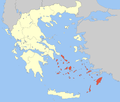 | |
|---|---|---|
| Regional unit of Kalymnos | ||
| Regional unit of Karpathos | ||
| Regional unit of Kea-Kythnos | ||
| Regional unit of Kos | ||
| Regional unit of Milos | ||
| Regional unit of Mykonos | ||
| Regional unit of Naxos | ||
| Regional unit of Paros | ||
| Regional unit of Rhodes | ||
| Regional unit of Syros | ||
| Regional unit of Thira | ||
| Regional unit of Tinos | ||