Nilgiri mountains
| Nilgiri Hills | |
|---|---|
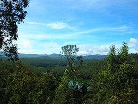 View of Nilgiri Hills | |
| Highest point | |
| Elevation | 2,637 m (8,652 ft) |
| Naming | |
| Translation | Blue Mountains |
| Geography | |
| Location | Tamil Nadu, Kerala, Karnataka |
| Parent range | Western Ghats |
| Geology | |
| Age of rock | Azoic Age, 3000 to 500 mya |
| Mountain type | Fault[1] |
| Climbing | |
| Easiest route |
NH 67 (Satellite view) or Nilgiri Mountain Railway |
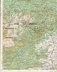
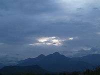
The Nilgiri (Blue Mountains), form part of the Western Ghats in western Tamil Nadu, Karnataka and Kerala states in Southern India. At least 24 of the Nilgiri mountains' peaks are above 2,000 metres (6,600 ft), the highest peak being Doddabetta, at 2,637 metres (8,652 ft).
Location
Spanning an area of 2,479 square kilometres (957 sq mi),[2] the mountains' central location is 11°22′30″N 76°45′30″E / 11.37500°N 76.75833°E.
The Nilgiris District of Tamil Nadu lies within these mountains, spanning 130 km (Latitude: 11° 08' to 11° 37' N) by 185 km (Longitude: 76° 27' E to 77° 4' E). It is connected via Nilgiri Mountain Railway.[3]
The mountains are separated from other geographical features by the Moyar River to the north (Karnataka plateau is beyond), and the Palghat Gap to the south (Anaimalai Hills and Palni Hills are past this).
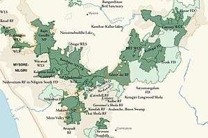
Conservation
The Nilgiri Hills are part of the Nilgiri Biosphere Reserve (itself part of the UNESCO World Network of Biosphere Reserves.[4]), and form a part of the protected bio reserves in India.
History
The high steppes of the Nilgiri Hills have been inhabited since prehistoric times, demonstrated by a large number of artifacts unearthed by excavators. A particularly important collection from the region can be seen in the British Museum, including those assembled by colonial officers James Wilkinson Breeks, Major M. J. Walhouse and Sir Walter Elliot.[5]
The first recorded use of the word Nila applied to this region can be traced back to 1117 AD. In the report of a general of Vishnuvardhana, King of Hoysalas, who in reference to his enemies, claimed to have "frightened the Todas, driven the Kongas underground,slaughtered the Poluvas, put to death the Maleyalas, terrified King Kala and then proceeded to offer the peak of Nila Mountain (presumably Doddabetta or Rangaswami peak of Peranganad in East Nilgiris) to Lakshmi, Goddess of Wealth."[6]
A hero stone (Veeragallu) with a Kannada inscription at Vazhaithottam (Bale thota) in the Nilgiri District, dated to 10th century CE, has been discovered.[7] A Kannada inscription of Hoysala king Ballala III (or his subordinate Madhava Dannayaka's son) from the 14th century CE has been discovered at the Siva (or Vishnu) temple at Nilagiri Sadarana Kote (present day Dannayakana Kote), near the junction of Moyar and Bhavani rivers, but the temple has since been submerged by the Bhavani Sagar dam.[7][8]
In 1814, Keys, a sub-assistant, and McMahon, an apprentice in the Survey Department, ascended the hills by the Danaynkeucottah (Dannayakana Kote) Pass, penetrated into the remotest parts, made plans, and sent in reports of their discoveries. As a result of these accounts, Messrs. Whish and Kindersley, two young Madras civilians, ventured up in pursuit of some criminals taking refuge in the mountains, and proceeded to observe the interior. They soon saw and felt enough favorable climate and terrain to excite their own curiosity, and that of others.[9]
With a detachment of Europeans and Indian sepoys, they set out on this mission on January 2, 1819. The journey involved crossing rough and harsh terrain, steep precipices and danger from wild animals. After an expedition that lasted for six days and the loss of some of the expedition members' lives, Sullivan finally reached a plateau from where he proudly hoisted the British flag. In May 1819, the same tourists from Coimbatore, accompanied by Monsieur Leschnault de la Tour, naturalist to the King of France, repeated their excursion. They asserted the temperature in the shade to be 74 °F (23 °C) at a time when the temperature of the plains was up to 100 °F (38 °C). Such a climate within the tropics was considered so great an anomaly that at first only a few believed its existence.
After the early 1820s, the hills were developed rapidly under the British Raj, because most of the land was already privately owned by British citizens. It was a popular summer and weekend getaway for the British during the colonial days. In 1827, Ooty became the official sanatorium and the summer capital of the Madras Presidency. Many winding hill roads were built. In 1899, the Nilgiri Mountain Railway was completed by influential and enterprising British citizens, with venture capital from the Madras government.[10]
In the 19th century, when the British Straits Settlement shipped Chinese convicts to be jailed in India, the Chinese men settled in the Nilgiri mountains near Naduvattam after their release and married Tamil Paraiyan women, having mixed Chinese-Tamil children with them. They were documented by Edgar Thurston.[11] Paraiyan is also anglicized as "pariah".
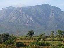
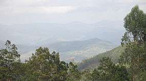
Peaks in the Nilgiris
showing some peaks
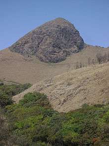
The highest point in the Nilgiris and the southern extent of the range is Doddabetta Peak (2,637 metres (8,652 ft)), 4 km east southeast of Udhagamandalam, 11°24′10″N 76°44′14″E / 11.40278°N 76.73722°E.
Closely linked peaks in the west of Doddabetta range and nearby Udhagamandalam include:
- Kolaribetta: height: 2,630 metres (8,629 ft),
- Hecuba: 2,375 metres (7,792 ft),
- Kattadadu: 2,418 metres (7,933 ft) and
- Kulkudi: 2,439 metres (8,002 ft).
Snowdon (height: (2,530 metres (8,301 ft)) 11°26′N 76°46′E / 11.433°N 76.767°E is the northern extent of the range. Club Hill (2,448 metres (8,031 ft)) and Elk Hill (2,466 metres (8,091 ft)) 11°23′55″N 76°42′39″E / 11.39861°N 76.71083°E are significant elevations in this range. Snowdon, Club Hill and Elk Hill with Doddabetta, form the impressive Udhagamandalam Valley.
Devashola (height: 2,261 metres (7,418 ft)), notable for its blue gum trees, is in the south of Doddabetta range.
Kulakombai (1,707 metres (5,600 ft)) is east of the Devashola. The Bhavani Valley and the Lambton's peak range of Coimbatore district stretch from here.
Hullikal Durg: (height: 562 metres (1,844 ft)), 11°19′N 76°53′E / 11.317°N 76.883°E In the Kannada language, Hulikal Durg means Tiger Rock Fort. The Sanskrit name of his place is Bakasura Parvata. It is 3 km. southeast of Coonoor. Tropical pine forest flourishes at the base of this hill, while the valleys support green foliage.
Coonoor Betta (2,101 metres (6,893 ft)) is also called Teneriffe. It is on the northern side of the gorge, accommodating the Nilgiri Mountain Railway to Coonoor.
Rallia Hill (height: 2,248 metres (7,375 ft))11°25′N 76°53′E / 11.417°N 76.883°E is in the midst of a reserved forest and almost equidistant from Udhagamandalam and Kotagiri.
Dimhatti Hill (height: 1,788 metres (5,866 ft)) 11°26′N 76°01′E / 11.433°N 76.017°E is above the Gajalahatti pass, which provided a short cut from Mysore to the Carnatic plains and was of much strategic importance in the eighteenth century. This peak, dedicated to the deity Rangaswamy, is considered holy by the people of the surrounding villages.
Avalanche hill of this range has the twin-peaks of Kudikkadu (height: 2,590 metres (8,497 ft)) and Kolaribetta (2,630 metres (8,629 ft)).
Derbetta (or Bear Hill) (height: 2,531 metres (8,304 ft)) and Kolibetta (height: 2,494 metres (8,182 ft)), south of the Ouchterlony valley, are a continuation of the Kundah range.
Mukurthi Peak 2,554 metres (8,379 ft)) 11°23′29″N 76°31′38″E / 11.39139°N 76.52722°E, Pichalbetta (height: 2,544 metres (8,346 ft)) and Nilgiri Peak (2,474 metres (8,117 ft)) 11°24′0″N 76°30′4″E / 11.40000°N 76.50111°E are the important heights of this area. These three hills of the Wayanad district are generally low in relation to other heights of the district but are distinguished in relation to the generally uniform level of this area.
Muttunadu Betta (height: 2,323 metres (7,621 ft)) 11°27′N 76°43′E / 11.450°N 76.717°E is about 5 km, north northwest of Udhagamandalam. Tamrabetta (Coppery Hill) (height: 2,120 metres (6,955 ft)) 11°22′N 76°48′E / 11.367°N 76.800°E is about 8 km southeast of Udhagamandalam. Vellangiri (Silvery Hill) (2,120 metres (6,955 ft)) is 16 km west-northwest of Udhagamandalam.[12]
Waterfalls
The highest waterfall, Kolakambai Fall, north of Kolakambai hill, has an unbroken fall of 400 ft (120 m). Nearby is the 150 ft (46 m) Halashana falls. The second highest is Catherine Falls, near Kotagiri, with a 250 ft (76 m) fall, named after the wife of M.D. Cockburn, believed to have introduced coffee plantations to the Nilgiri Hills. The Upper and Lower Pykara falls have falls of 180 ft (55 m), and 200 ft (61 m), respectively. The 170 ft (52 m) Kalhatti Falls is off the Segur Peak. The Karteri Fall, near Aruvankadu had the first power station which supplied the original Cordite Factory with electricity. Law's Fall, near Coonoor, is interesting due to its association with the engineer Major G. C. Law who supervised building of the Coonoor Ghat road.[2]
Flora and fauna
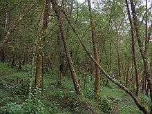
Over 2,700 species of flowering plants, 160 species of fern and fern allies, countless types of flowerless plants, mosses, fungi, algae, and land lichens are found in the sholas of the Nilgiris. No other hill station has so many exotic species.[13]
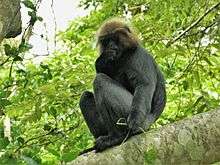
The Nilgiri tahr can be found in the hills.[14]
Much of the Nilgiris' natural montane grasslands and shrublands interspersed with sholas has been much disturbed or destroyed by extensive tea plantations, easy motor-vehicle access, extensive commercial planting and harvesting of non-native eucalyptus and wattle (Acacia dealbata, Acacia mearnsii) plantations, and cattle grazing.[15] The area also features one large and several smaller hydro-electric impoundments.[16] Scotch broom has become an ecologically damaging invasive species.[17]
Threatened plants of the Nilgiris include:
- Vulnerable species: Miliusa nilagirica, Nothapodytes nimmoniana, Commelina wightii
- Rare species: Ceropegia decaisneana Ceropegia pusilla, Senecio kundaicus
- Endangered species: Youngia nilgiriensis, Impatiens neo-barnesii, Impatiens nilagirica, Euonymus angulatus and Euonymus serratifolius.[18]
References
- ↑ "Application of GPS and GIS for the detailed Development planning". Map India 2000. 10 April 2000. Archived from the original on 2008-06-03. Retrieved 2011-06-05.
- 1 2 EAGAN, J. S. C (1916). The Nilgiri Guide And Directory. VEPERY: S.P.C.K. PRESS.
- ↑ "Nilgiri Mountain Railway". railtourismindia.com. Retrieved 8 March 2013.
- ↑ UNESCO, World Heritage sites, Tentative lists, Western Ghats (sub cluster nomination), retrieved 4/20/2007 World Heritage sites, Nilgiri Sub-Cluster
- ↑ "Collection search: You searched for Nilgiri". British Museum. Retrieved 2016-08-09.
- ↑ Pai, Mohan (15 January 2009). ...and they created little England. The Western Ghats - Hill Stations. the-western-ghats-by-mohan-pai-hill-stations, Egmore, Chennai. pp. Ootacamund.
- 1 2 "Kannada script (10600)". Department of Archaeology - Tamil Nadu. Tamil Nadu Government.
- ↑ Francis, Walter (1908). Madras District Gazetteers: The Nilgiris. 1. New Delhi: Asian Educational Services. pp. 90–94, 102–105. ISBN 978-81-2060-546-6.
- ↑ Burton, Richard Francis, (1851). "Nilgiri Hills (India), Description and travel; Nilgiri Hills (India), Social life and customs". Goa, and the Blue Mountains, or, Six months of sick leave. London: R. Bentley.
- ↑ "Ooty Queen of hill stations". www.ooty.com. Retrieved 2011-06-05.
- ↑ Sarat Chandra Roy (Rai Bahadur), ed. (1959). Man in India, Volume 39. A. K. Bose. p. 309. Retrieved 2 March 2012.
d: TAMIL-CHINESE CROSSES IN THE NILGIRIS, MADRAS. S. S. Sarkar* (Received on 21 September 1959) During May 1959, while working on the blood groups of the Kotas of the Nilgiri Hills in the village of Kokal in Gudalur, inquiries were made regarding the present position of the Tamil-Chinese cross described by Thurston (1909). It may be recalled here that Thurston reported the above cross resulting from the union of some Chinese convicts, deported from the Straits Settlement, and local Tamil Paraiyan
- ↑ District Administration, Nilgiris (8/20/2007) National Informatics Centre, Nilgiris, retrieved 8/31/2007 Hills and Peaks
- ↑ The District Collector, Collector's Office, Udhagamandalam, The Nilgiris District, Tamil Nadu, General Information, RARE TREES, FRUITS, FLOWERS & ANIMALS retrieved 9/2/2007.
- ↑ "Nilgiri Tahr". WWF. Retrieved 8 March 2013.
- ↑ Davidar, E. R. C. 1978. Distribution and status of the Nilgiri tahr (Hemitragus hylocrius) 1975-1978. Journal of the Bombay Natural History Society; 75: 815-844.
- ↑ Rice, C G Dr (1984) US Fish and Wildlife Service, Washington, USA, "The behaviour and ecology of Nilgiri Tahr", Tahr Foundation, retrieved 4/17/2007. Archived 28 September 2006 at the Wayback Machine.
- ↑ Journal of the Bombay Natural History Society, 103 (2-3), May-Dec 2006 356-365 HABITAT MODIFICATIONS BY SCOTCH BROOM CYTISUS SCOPARIUS INVASION OF GRASSLANDS OF THE UPPER NILGIRIS IN INDIA, ASHFAQ AHMED ZARRI1, 2, ASAD R. RAHMANI1,4 AND MARK J. BEHAN3 Archived 19 December 2008 at the Wayback Machine.
- ↑ Nayar & Sastry (1987-88) Red Data Book, Plants of India Threatened Plants of Tamil Nadu
External links
 Media related to Nilgiris at Wikimedia Commons
Tourism in The Nilgiris | ||
|---|---|---|
Gardens and parks
.jpg) |  | |
Viewpoint
 | ||
Lake and waterfalls
 | ||
Other tourist spots
 | ||
Events
 | ||