Niksar
| Niksar | |
|---|---|
|
Niksar view from the city center | |
 Niksar | |
| Coordinates: 40°35′0″N 36°58′0″E / 40.58333°N 36.96667°ECoordinates: 40°35′0″N 36°58′0″E / 40.58333°N 36.96667°E | |
| Country |
|
| Province | Tokat |
| Government | |
| • Mayor | Özdilek Özcan |
| Area[1] | |
| • District | 918.28 km2 (354.55 sq mi) |
| Population (2012)[2] | |
| • Urban | 32,692 |
| • District | 63,724 |
| • District density | 69/km2 (180/sq mi) |
| Post code | 60600 |
| Website |
www |

Niksar /'niksar/ (Greek: Νεοκαισάρεια, Neokaisáreia) is a city in Tokat Province, Turkey. It was settled by many empires, being once the capital city of the province. Niksar is known as "Çukurova of the North-Anatolia" due to its production of many kinds of fruits and vegetables except citrus fruits.
History
Niksar has been ruled by the Hittite, Persian, Greek, Pontic, Roman, Byzantine, Danishmend, Seljuk and Ottoman Empires. It has always been an important place in Anatolia because of its location, climate and productive lands.
It was known as Cabira in the Hellenistic period (Κάβειρα in Greek). It was one of the favourite residences of Mithridates the Great, who built a palace there, and later of King Polemon I and his successors.[3]
In 72 or 71 BC, the Battle of Cabira during the Third Mithridatic War took place at Niksar, and the city passed to the Romans. Niksar was called Diospolis, Sebaste, and Neokaisareia during the Roman period. Pompey made it a city and gave it the name of Diopolis, while Pythodoris, widow of Polemon, made it her capital and called it Sebaste. It is not known precisely when it assumed the name of Neokaisareia, mentioned for the first time in Pliny, "Hist. Nat.", VI, III, 1, but judging from its coins, one might suppose that it was during the reign of Tiberius.[3] In 344 the city was completely destroyed by an earthquake (Hieronymus, "Chron.", anno 2362).[3] Neokaisareia became part of the Eastern Roman Empire when the Roman Empire divided into two parts in AD 395. Another earthquake occurred in 499 (Theodorus Lector, II, 54).[3] The town was later rule by the Byzantines.
During the Middle Ages, the Muslims and Christians disputed the possession of Neokaisareia, and in 1068 a Seljuk general, Melik-Ghazi, whose tomb is still visible, captured and pillaged it. When the Seljuqs raided Anatolia in 1067, Neocæsarea was conquered by Afşın Bey, one of the commanders of Alp Arslan. The Byzantines retook the area in 1068. Conquered by Artuk Bey after the Battle of Manzikert, Neocæsarea once again returned to Byzantium in 1073. Melik Gümüştekin Ahmet Gazi (better known as Danishmend Gazi), founder of the Danishmend, was the real conqueror of Neocæsarea. After the conquest the Gazi made it his capital city, and, under the name Niksar, became a center of science and culture. The Danishmend Gazi's mausoleum stands in a large cemetery just outside the town.
By 1175, during the reign of Kılıç Arslan II, Niksar was dependent on the Seljuks of Rum. After the Mongol invasion of the 13th century, Niksar was governed by the Eretnids and then the Beylik of Tacettin, an beylik and became the center of the latter principality. After Kadı Burhanettin (who conquered Niksar in 1387) was killed in battle, the people of Niksar sought aid from the Ottoman Sultan Bayezid I. The Sultan's son, Süleyman Çelebi, took Niksar for the Ottomans. In the later Ottoman period, Niksar became part of Tokat Province. Fatih Mehmet launched a raid on Trabzon from Niksar, and Selim I and Suleiman the Magnificent raided the east from there. The town was predominantly Muslim in the mid 17th century.[4]
In 1919, a meeting was organized in Niksar to protest against the Greek occupation of İzmir.
Ecclesiastical history
Neocaesarea was an episcopal see in the late Roman province of Pontus Polemoniacus. It became the civil and religious metropolis of Pontus. In around 315, the Synod of Neo-Caesarea was held there. Noted bishops include Saints Gregory Thaumaturgus, Paul of Neocaesarea, and Thomas, a 9th-century martyr.
Geographic location
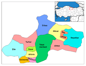
Niksar is approximately 9,555 km2 (3,689 sq mi). It is located at 40°35' north latitude and 36°58' east longitude. Its average altitude is 350m above sea level. It is surrounded by Erbaa on the northwest, Tokat on the southwest, Almus on the south, Başçiftlik on the southeast and Akkuş on the north. It is one of the five largest counties of Tokat. The Canik Mountains are to the north, Dönek Mountain to the south, and the Niksar Lowland is situated between these mountains. The Niksar Lowland is one of the most important lowlands of the Black Sea Region. The Canik Mountains are covered with plateaus that lie parallel to the Black Sea. Çamiçi High Plateau is one of the most important ones.
Niksar lands are irrigated by large and small tributaries of the Kelkit River. Forests cover 53% of the plateau, and pasture 12%; 32% of the land is devoted to agriculture, and only 3% is unsuitable for farming. Beech, pine, horn beech, and spruce trees can be found in the higher altitudes to the north of Niksar. In the lowlands there are poplar and willow trees, and fruit trees in the valleys. Polecats, rabbits, wolves, foxes, lynxes, bears, and pigs are the main hunting animals that live in the mountains and forests. Partridges, quail and ducks are among the more important game birds found here. Niksar has a transitional climate between the Middle Black Sea and Inner Anatolia. It is generally slightly warm and rainy in winter and hot in summer. The county averages an annual rainfall of 475.2 mm, and the annual average temperature is 14.7 °C.
Cuisine of Niksar

The most remarkable feature of traditional Tokat-Niksar houses is the kitchen. Called Aşevi or Aşgana in the local dialect, the kitchen is usually the largest room of the house and serves as a sort of lounge for the family. The typical kitchen has a fireplace on one side used for cooking or washing and a storeroom on the other in which dried foods, preserves, sauces, cheese and grape leaves are kept. Beside the storeroom is a wooden granary with partitions for storing cereals and legumes. In Turkey, it is common to eat meals around a low table.
References
- ↑ "Area of regions (including lakes), km²". Regional Statistics Database. Turkish Statistical Institute. 2002. Retrieved 2013-03-05.
- ↑ "Population of province/district centers and towns/villages by districts - 2012". Address Based Population Registration System (ABPRS) Database. Turkish Statistical Institute. Retrieved 2013-02-27.
- 1 2 3 4 Catholic Encyclopedia, 1907, s.v. Neocaesarea
- ↑ Sinclair, T.A. (1989). Eastern Turkey: An Architectural & Archaeological Survey, Volume I. Pindar Press. p. 389. ISBN 9780907132325.
External links
| Wikimedia Commons has media related to Niksar. |
![]() This article incorporates text from a publication now in the public domain: Smith, William, ed. (1854–1857). "article name needed". Dictionary of Greek and Roman Geography. London: John Murray.
This article incorporates text from a publication now in the public domain: Smith, William, ed. (1854–1857). "article name needed". Dictionary of Greek and Roman Geography. London: John Murray.