Niikappu, Hokkaido
| Niikappu 新冠町 | ||
|---|---|---|
| Town | ||
| ||
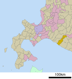 Location of Niikappu in Hokkaido (Hidaka Subprefecture) | ||
 Niikappu Location in Japan | ||
| Coordinates: 42°22′N 142°19′E / 42.367°N 142.317°ECoordinates: 42°22′N 142°19′E / 42.367°N 142.317°E | ||
| Country | Japan | |
| Region | Hokkaido | |
| Prefecture | Hokkaido (Hidaka Subprefecture) | |
| District | Niikappu | |
| Government | ||
| • Mayor | Kotake Kuniaki (小竹 國昭)[1] | |
| Area | ||
| • Total | 585.88 km2 (226.21 sq mi) | |
| Population (March 2008[1]) | ||
| • Total | 6,022 | |
| • Density | 10/km2 (27/sq mi) | |
| Symbols | ||
| • Tree | Higatsura (ヒガツラ) | |
| • Flower | Azalea (ツツジ Tsutsuji) | |
| Time zone | Japan Standard Time (UTC+9) | |
| City hall address |
3-2 Aza-Hokusei-chō, Niikappu-chō, Niikappu-gun, Hokkaidō 059-2492[1] | |
| Website |
www | |

Niikappu (新冠町 Niikappu-chō) is a town located in Niikappu District, Hidaka Subprefecture, Hokkaido, Japan.
History
The town was established September 1881.[1]
Geography
Niikappu stretches from the Pacific Ocean of southeast Hokkaido north to the Hidaka Mountains along the Niikappu River. The town covers a total area of 585.88 km².[1] Its highest point is Mount Poroshiri and the lowest is at the coast. The town runs 45 kilometres (28 mi) East-West and 44 kilometres (27 mi) North-South[1]
Economy

Cliff art outside Niikappu (1992)
The town is mainly known for production of racehorses, including Haiseiko, Narita Brian, and Oguri Cap.
Art and Culture
Niikappu has a large collection of records.
Other features of Niikappu include:
- A mud volcano deikazan (Supposedly the only one in Japan.)
- Hangandate with playground and ocean view
- A Youth Hostel
- Shonen Shizen no Ie boys' nature house
- A campground
Transportation
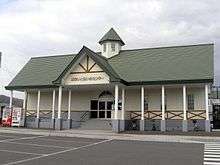
Niikappu Station on the Hidaka Main Line (April 2000)
- Hidaka Main Line
- Donan Bus (道南バス Donan-basu)
References
External links
 Media related to Niikappu, Hokkaidō at Wikimedia Commons
- Official website (Japanese)
This article is issued from Wikipedia - version of the 3/17/2016. The text is available under the Creative Commons Attribution/Share Alike but additional terms may apply for the media files.