Niederkassel
For the neighbourhood in Düsseldorf, see Düsseldorf-Niederkassel.
| Niederkassel | ||
|---|---|---|
| ||
 Niederkassel | ||
Location of Niederkassel within Rhein-Sieg-Kreis district 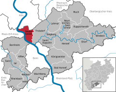
 | ||
| Coordinates: 50°49′N 7°02′E / 50.817°N 7.033°ECoordinates: 50°49′N 7°02′E / 50.817°N 7.033°E | ||
| Country | Germany | |
| State | North Rhine-Westphalia | |
| Admin. region | Köln | |
| District | Rhein-Sieg-Kreis | |
| Government | ||
| • Mayor | Stephan Vehreschild (CDU) | |
| Area | ||
| • Total | 35.79 km2 (13.82 sq mi) | |
| Population (2015-12-31)[1] | ||
| • Total | 37,583 | |
| • Density | 1,100/km2 (2,700/sq mi) | |
| Time zone | CET/CEST (UTC+1/+2) | |
| Postal codes | 53859 | |
| Dialling codes | 02208; 0228 | |
| Vehicle registration | SU | |
| Website | www.niederkassel.de | |

Niederkassel (Colognian: Neddekaaßel) is a town in the Rhein-Sieg district, in North Rhine-Westphalia, Germany, with a population of around 37,000 people. It is situated on the right bank of the Rhine, approx. 10 km (6 mi) north-east of Bonn and 15 km (9 mi) south-east of Cologne. Niederkassel is subdivided into seven quarters (from the south to the north): Mondorf, Rheidt, Niederkassel, Uckendorf, Stockem, Lülsdorf and Ranzel. People can walk next to the river Rhine in Lülsdorf, Niederkassel and Rheidt.
International relations
Twin towns – Sister cities
Niederkassel is twinned with:
References
- ↑ "Amtliche Bevölkerungszahlen". Landesbetrieb Information und Technik NRW (in German). 18 July 2016.
- ↑ "Limassol Twinned Cities". Limassol (Lemesos) Municipality. Archived from the original on 2013-04-01. Retrieved 2013-07-29.
Towns and municipalities in Rhein-Sieg-Kreis | ||
|---|---|---|
This article is issued from Wikipedia - version of the 9/26/2016. The text is available under the Creative Commons Attribution/Share Alike but additional terms may apply for the media files.