Nideggen
| Nideggen | ||
|---|---|---|
| ||
 Nideggen | ||
Location of Nideggen within Düren district 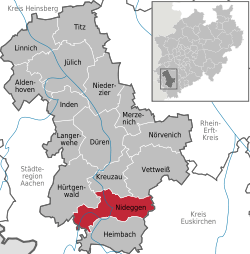 | ||
| Coordinates: 50°42′00″N 06°29′00″E / 50.70000°N 6.48333°ECoordinates: 50°42′00″N 06°29′00″E / 50.70000°N 6.48333°E | ||
| Country | Germany | |
| State | North Rhine-Westphalia | |
| Admin. region | Köln | |
| District | Düren | |
| Government | ||
| • Mayor | Margit Göckemeyer (partyless) | |
| Area | ||
| • Total | 65.04 km2 (25.11 sq mi) | |
| Population (2015-12-31)[1] | ||
| • Total | 9,893 | |
| • Density | 150/km2 (390/sq mi) | |
| Time zone | CET/CEST (UTC+1/+2) | |
| Postal codes | 52385 | |
| Dialling codes | 02425, 02427, 02474 | |
| Vehicle registration | DN, JÜL | |
| Website | www.nideggen.de | |


Nideggen is a town in the district of Düren in the state of North Rhine-Westphalia, Germany. It is located on the river Rur, in the Eifel hills, approx. 15 km south of Düren.
Nideggen is known for its ruined, but partly restored castle (Burg Nideggen) and the sandstone rocks along the Rur. It is twinned with Thatcham in Berkshire, England. The first mention in history was in 1184.
The town was created in 1972 by amalgamation of eight until then independent communities: Abenden (782 inhabitants), Berg-Thuir (709), Brück (301), Embken (734), Muldenau (161), Nideggen (2.983), Rath (757), Schmidt (2.974), Wollersheim (637) (December 2014). It is situated between 250 and 450 metres above sea level.
Geographical position
Nideggen lies on the river Rur and at the banks of the Rurtalsperre, the second largest dam in Germany. The region is famous for its precipitous Early Triassic rocks of Buntsandstein in the valley of Rur and is situated between 250 and 450 metres over sea level.
Towns and municipalities in Düren (district) | ||
|---|---|---|
References
- ↑ "Amtliche Bevölkerungszahlen". Landesbetrieb Information und Technik NRW (in German). 18 July 2016.