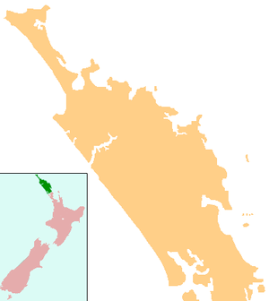
Ngunguru
| Ngunguru | |
|---|---|
|
Ngunguru coast | |
 Ngunguru | |
| Coordinates: 35°38′04″S 174°30′00″E / 35.63444°S 174.50000°ECoordinates: 35°38′04″S 174°30′00″E / 35.63444°S 174.50000°E | |
| Country | New Zealand |
| Region | Northland Region |
| District | Whangarei District |
| Population (2006) | |
| • Total | 1,425 |
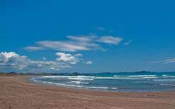
Ngunguru is a coastal settlement in Northland, New Zealand. Whangarei is 26 km to the south west. The Ngunguru River flows between the settlement and a long low sandspit into Whangaumu Bay, which stretches southwards. North of Ngunguru are Tutukaka and Matapouri[1][2]
The population was 1425 in the 2006 Census, an increase of 138 from 2001.[3]
Ngunguru means "rumbling tides" in the Māori language.[4]
History
The waka Tūnui-ā-rangi, which brought Ngāi Tāhuhu to New Zealand according to traditional accounts, visited Ngunguru on its way from the Bay of Islands to Whangarei.[5] The area was named by Puhi, captain of another waka, Mataatua.[6]
In pre-European times, there was a substantial Māori population in the area.[7] The Ngunguru sandspit was the scene of a battle between southern tribes and Te Waiariki in 1838.[8]
The first chart of "Nongodo" was drawn by Captain N. C. Phillips of the HMS Buffalo in 1836.[7] James Busby, Gilbert Mair and W. J. Lewington bought 40,000 acres (16,000 ha) at Ngunguru in 1840, although the government disputed the sale for the next 30 years and attempted to buy the land itself from the original Māori owners.[9][10] They established one of the earliest sawmills in the country at Ngunguru in 1840 to take advantage of the abundant kauri timber. It was water-powered.[11] The mill failed financially in 1844,[12] but others succeeded in the industry and Ngunguru exported timber and especially roofing shingles for many years.[7]
The Melanesian Mission ship Southern Cross was wrecked in Ngunguru Bay in 1860.[7][13]
A bullock track was built to Whangarei in the 1860s.[14] In 1892, coal was discovered at Kiripaka, at the headwaters of the Ngunguru River. 620,000 long tons (630,000 t) were mined until 1921.[7]
The beach settlement developed after roading was improved in the 1950s.[15] An attempt to sell the Ngunguru sandspit for property development in 2005 attracted considerable local opposition, and no buyers.[16] In August 2011 the government purchased the spit from the Todd Property Group. The Department of Conservation will administer the reserve, which is one of a small number of sand spits that are relatively intact from an ecological perspective. Four separate assessments have ranked the spit as nationally significant[17]
Education
Ngunguru School is a coeducational full primary (years 1-8) school with a decile rating of 7 and a roll of 238.[18] The school celebrated its centennial in 1970.[19]
References
- ↑ Just off the Ngunguru Coast are the Poor Knight Islands,a protected marine reserve. Peter Dowling (editor) (2004). Reed New Zealand Atlas. Reed Books. pp. map 8. ISBN 0-7900-0952-8.
- ↑ Roger Smith, GeographX (2005). The Geographic Atlas of New Zealand. Robbie Burton. pp. map 25. ISBN 1-877333-20-4.
- ↑ Quickstats about Ngunguru
- ↑ "Whāngārei tribes". Te Ara Encyclopedia of New Zealand.
- ↑ "Canoe traditions - Other northern canoes". Te Ara Encyclopedia of New Zealand.
- ↑ "Whāngārei tribes - Ancestors". Te Ara Encyclopedia of New Zealand.
- 1 2 3 4 5 Parkes, W. F. (1992). Guide to Whangarei City and District. p. 37. ISBN 0-473-01639-7.
- ↑ "Sandspit Timeline". Retrieved 2010-04-01.
- ↑ "Busby, James". Encyclopedia of New Zealand (1966).
- ↑ Pickmere, Nancy Preece (1986). Whangarei: The Founding Years. p. 27.
- ↑ "Whāngārei Harbour and north". Te Ara Encyclopedia of New Zealand.
- ↑ Pickmere, pp 27-30
- ↑ "Australian and New Zealand shipwrecks".
- ↑ Pickmere, p 132
- ↑ "Whangarei". Encyclopedia of New Zealand (1966).
- ↑ Powley, Kathryn (16 July 2005). "Ngunguru Sandspit off market". The Northern Advocate.
- ↑ "Ngunguru Spit purchase a win for conservation". New Zealand Government (Beehive). 25 August 2011. Retrieved 25 August 2011.
- ↑ . Ministry of Education https://www.educationcounts.govt.nz/statistics/schooling/student-numbers/6028. Missing or empty
|title=(help) - ↑ Ngunguru School Centennial 1870-1970 : souvenir booklet. Ngunguru School. 1971. Retrieved 14 August 2009.