Ngor Okpala
| Ngor Okpala | |
|---|---|
| Country |
|
| State | Imo State |
| Time zone | WAT (UTC+1) |
Ngor Okpala is a Local Government Area of Imo State, Nigeria. Its headquarters are in the town of Umuneke Ngor.
It has an area of 561 km² and a population of 159,932 at the 2006 census.is notable place in Imo state because of her locational position. connects Abia and Rivers states of Nigeria. is the largest local government area in Imo State and one of the largest in Nigeria.
The postal code of the area is 460.[1] There are so many Communities in They include: Obiangwu,Ntu, Alulu, Amala, Oburu, Obokwe, Eziama, Okpala, Ohekelem, Ihite, Obike, Elelem, Umuohiagu,Umuhu,Imerienwe, Nguru-Umuaro,Orishi-eze, umuekwune, Ngali, and umukabia-ngodo and many others. Imo airport is situated in Ngor-Okpala is one of the fastest developing local governments in Imo State. is blessed with natural and mineral resources which have not been tapped.The natives also term themselves as people of nod nor impala. In okpala there are seven communities known as ama-asaa .Okpala is one of the village in ama-asaa, due to the popularity of the name it takes over the name 'ama-asaa', 'okpala junction'.Okpala the central of the seven villages has four kindred which include amankwu, amaube,amanwaebo and umuokereke.
References
- ↑ "Post Offices- with map of LGA". NIPOST. Retrieved 2009-10-20.
State capital: Owerri | ||
| LGAs | 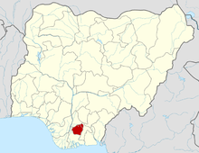 | |
Ngor okpala also consist of Umuekwune.