Nez Perce County, Idaho
| Nez Perce County, Idaho | ||
|---|---|---|
| ||
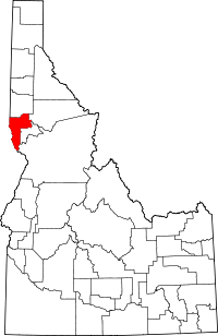 Location in the U.S. state of Idaho | ||
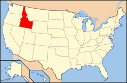 Idaho's location in the U.S. | ||
| Founded | February 4, 1864 | |
| Named for | Nez Percé tribe | |
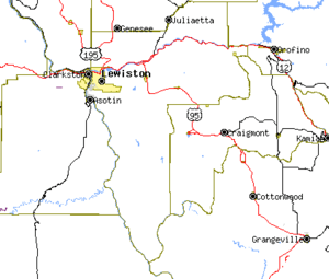
| Seat | Lewiston | |
| Largest city | Lewiston | |
| Area | ||
| • Total | 856 sq mi (2,217 km2) | |
| • Land | 848 sq mi (2,196 km2) | |
| • Water | 8.2 sq mi (21 km2), 0.85% | |
| Population (est.) | ||
| • (2015) | 40,048 | |
| • Density | 46/sq mi (18/km²) | |
| Congressional district | 1st | |
| Time zone | Pacific: UTC-8/-7 | |
| Website |
www | |

Nez Perce County (pron. Nezz Purse) is a county located in the U.S. state of Idaho. As of the 2010 census, the population was 39,265.[1] The county seat is Lewiston.[2] The county is named after the Nez Percé tribe.
Nez Perce County is part of the Lewiston, ID-WA Metropolitan Statistical Area.
History
Nez Perce County was originally organized in 1861, when the area was part of Washington Territory. It was reorganized in 1864 by the Idaho Territorial Legislature and was later subdivided into new counties. Rapid migration to the Palouse in the 1880s led to the formation of Latah County in 1888. Isolated from its county seat of Wallace in the Silver Valley, the southern portion of Shoshone County was annexed by Nez Perce County in 1904, then became Clearwater County in 1911.[3] Lewis County was also formed from Nez Perce County in 1911.
Geography
According to the U.S. Census Bureau, the county has a total area of 856 square miles (2,220 km2), of which 848 square miles (2,200 km2) is land and 8.2 square miles (21 km2) (1.0%) is water.[4]
Nez Perce County has two rivers, the Clearwater and the Snake, which meet in Lewiston and then flow west. The Clearwater flows from the east and the Snake from the south, creating the state border with Washington (and further upstream, Oregon). The lowest point in the state of Idaho is located on the Snake River in Lewiston in Nez Perce County, where it flows out of Idaho and into Washington. North of Lewiston, Idaho's western border is a political line.
The northern portion of the county is part of the Palouse, a wide and rolling agricultural region of the middle Columbia basin.
Adjacent counties
- Latah County - north
- Clearwater County - northeast
- Lewis County - east
- Idaho County - southeast
- Wallowa County, Oregon - southwest
- Asotin County, Washington - west
- Whitman County, Washington - northwest
Major highways
National protected areas
- Clearwater National Forest (part)
- Nez Perce National Historical Park (part)
- Wallowa–Whitman National Forest (part)
Government and politics
Nez Perce County is currently strongly Republican, though less so than southern Idaho: it is one of only nine counties (out of forty-four) in Idaho that has failed to vote Republican in any presidential election since 1968,[5] and indeed supported Dukakis and Bill Clinton (by plurality) three times in succession from 1988 to 1996.
In 2004 Republican George W. Bush defeated Democrat John Kerry 62% to 36%. In 2008 Republican John McCain defeated Democrat Barack Obama by a slightly smaller margin of 58.11 percent to 39.97 percent,[6] a result almost exactly replicated by Mitt Romney in 2012. In 2016 Donald Trump increased the Republican majority to 62.2 percent as against Hilary Clinton’s 28.1 percent.[7]
Demographics
| Historical population | |||
|---|---|---|---|
| Census | Pop. | %± | |
| 1870 | 1,607 | — | |
| 1880 | 3,965 | 146.7% | |
| 1890 | 2,847 | −28.2% | |
| 1900 | 13,748 | 382.9% | |
| 1910 | 24,860 | 80.8% | |
| 1920 | 15,253 | −38.6% | |
| 1930 | 17,591 | 15.3% | |
| 1940 | 18,873 | 7.3% | |
| 1950 | 22,568 | 19.6% | |
| 1960 | 27,066 | 19.9% | |
| 1970 | 30,276 | 11.9% | |
| 1980 | 33,220 | 9.7% | |
| 1990 | 33,754 | 1.6% | |
| 2000 | 37,410 | 10.8% | |
| 2010 | 39,265 | 5.0% | |
| Est. 2015 | 40,048 | [8] | 2.0% |
| U.S. Decennial Census[9] 1790-1960[10] 1900-1990[11] 1990-2000[12] 2010-2013[1] | |||
2000 census
As of the census[13] of 2000, there were 37,410 people, 15,286 households, and 10,149 families residing in the county. The population density was 44 people per square mile (17/km²). There were 16,203 housing units at an average density of 19 per square mile (7/km²). The racial makeup of the county was 91.58% White, 0.28% Black or African American, 5.31% Native American, 0.65% Asian, 0.07% Pacific Islander, 0.50% from other races, and 1.60% from two or more races. 1.93% of the population were Hispanic or Latino of any race. 25.1% were of German, 11.3% English, 11.0% American, 8.9% Irish and 5.6% Norwegian ancestry according to Census 2000.
There were 15,286 households out of which 29.00% had children under the age of 18 living with them, 52.80% were married couples living together, 9.30% had a female householder with no husband present, and 33.60% were non-families. 26.70% of all households were made up of individuals and 11.30% had someone living alone who was 65 years of age or older. The average household size was 2.40 and the average family size was 2.90.
In the county the population was spread out with 23.80% under the age of 18, 10.00% from 18 to 24, 26.70% from 25 to 44, 23.00% from 45 to 64, and 16.50% who were 65 years of age or older. The median age was 38 years. For every 100 females there were 96.70 males. For every 100 females age 18 and over, there were 93.80 males.
The median income for a household in the county was $36,282, and the median income for a family was $44,212. Males had a median income of $34,688 versus $23,014 for females. The per capita income for the county was $18,544. About 8.60% of families and 12.20% of the population were below the poverty line, including 15.40% of those under age 18 and 6.70% of those age 65 or over.
2010 census
As of the 2010 United States Census, there were 39,265 people, 16,241 households, and 10,331 families residing in the county.[14] The population density was 46.3 inhabitants per square mile (17.9/km2). There were 17,438 housing units at an average density of 20.6 per square mile (8.0/km2).[15] The racial makeup of the county was 90.1% white, 5.6% American Indian, 0.7% Asian, 0.3% black or African American, 0.1% Pacific islander, 0.7% from other races, and 2.5% from two or more races. Those of Hispanic or Latino origin made up 2.8% of the population.[14] In terms of ancestry, 30.6% were German, 14.5% were Irish, 13.5% were English, and 7.7% were American.[16]
Of the 16,241 households, 28.1% had children under the age of 18 living with them, 48.8% were married couples living together, 10.3% had a female householder with no husband present, 36.4% were non-families, and 28.6% of all households were made up of individuals. The average household size was 2.36 and the average family size was 2.88. The median age was 40.8 years.[14]
The median income for a household in the county was $44,395 and the median income for a family was $55,180. Males had a median income of $42,451 versus $31,920 for females. The per capita income for the county was $23,899. About 8.5% of families and 11.6% of the population were below the poverty line, including 16.2% of those under age 18 and 5.9% of those age 65 or over.[17]
Communities
Cities
Census-designated place
Unincorporated communities
See also
Footnotes
- 1 2 "State & County QuickFacts". United States Census Bureau. Retrieved July 1, 2014.
- ↑ "Find a County". National Association of Counties. Retrieved 2011-06-07.
- ↑ clearwatercounty.org - about us - history - accessed 2011-12-09
- ↑ "US Gazetteer files: 2010, 2000, and 1990". United States Census Bureau. 2011-02-12. Retrieved 2011-04-23.
- ↑ Sullivan, Robert David; ‘How the Red and Blue Map Evolved Over the Past Century’; America Magazine in The National Catholic Review; June 29, 2016
- ↑ US Election Atlas.org
- ↑ 2016 Presidential General Election Data Graphs – Idaho by County
- ↑ "County Totals Dataset: Population, Population Change and Estimated Components of Population Change: April 1, 2010 to July 1, 2015". Retrieved July 2, 2016.
- ↑ "U.S. Decennial Census". United States Census Bureau. Retrieved July 1, 2014.
- ↑ "Historical Census Browser". University of Virginia Library. Retrieved July 1, 2014.
- ↑ "Population of Counties by Decennial Census: 1900 to 1990". United States Census Bureau. Retrieved July 1, 2014.
- ↑ "Census 2000 PHC-T-4. Ranking Tables for Counties: 1990 and 2000" (PDF). United States Census Bureau. Retrieved July 1, 2014.
- ↑ "American FactFinder". United States Census Bureau. Retrieved 2008-01-31.
- 1 2 3 "DP-1 Profile of General Population and Housing Characteristics: 2010 Demographic Profile Data". United States Census Bureau. Retrieved 2016-01-09.
- ↑ "Population, Housing Units, Area, and Density: 2010 - County". United States Census Bureau. Retrieved 2016-01-09.
- ↑ "DP02 SELECTED SOCIAL CHARACTERISTICS IN THE UNITED STATES – 2006-2010 American Community Survey 5-Year Estimates". United States Census Bureau. Retrieved 2016-01-09.
- ↑ "DP03 SELECTED ECONOMIC CHARACTERISTICS – 2006-2010 American Community Survey 5-Year Estimates". United States Census Bureau. Retrieved 2016-01-09.
Further reading
- John M. Henderson and William S. Shiach, with Harry B. Averill, An Illustrated History of North Idaho: Embracing Nez Perces, Idaho, Latah, Kootenai and Shoshone Counties, State of Idaho. n.c. [Chicago]: Western Historical Publishing Co., 1903.
 |
Whitman County, Washington | Latah County | Clearwater County | |
| Asotin County, Washington | |
Lewis County | ||
| ||||
| | ||||
| Wallowa County, Oregon | Idaho County |
Municipalities and communities of Nez Perce County, Idaho, United States | ||
|---|---|---|
| Cities | ||
| CDP | ||
| Unincorporated communities | ||
Coordinates: 46°20′N 116°45′W / 46.33°N 116.75°W