Newark Bay Bridge
| Newark Bay Bridge | |
|---|---|
|
| |
| Coordinates | 40°41′43″N 74°07′06″W / 40.6953°N 74.1184°WCoordinates: 40°41′43″N 74°07′06″W / 40.6953°N 74.1184°W |
| Carries |
4 lanes of |
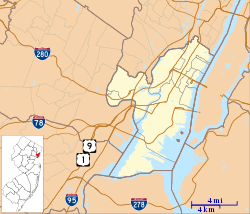
| Crosses | Newark Bay |
| Locale | Newark, New Jersey and Bayonne, New Jersey |
| Official name | Vincent R. Casciano Memorial Bridge |
| Other name(s) | The Turnpike Bridge |
| Maintained by | New Jersey Turnpike Authority |
| Characteristics | |
| Design | Three-span continuous through arch bridge |
| Total length | 9,560 feet |
| Width | 115 feet |
| Longest span | 387.10 meters (1,270 feet) |
| Clearance above | 135 feet |
| Clearance below | 135 feet (41.15 meters) |
| History | |
| Opened | April 4, 1956 |
| Statistics | |
| Daily traffic | 65,000 |
| Toll | from NJ Turnpike $1.65 (EZ Pass Peak/Cash) and $1.35 (EZ Pass Off peak) for exit 14 to 14A : $2.15 (EZ Pass Peak/Cash) and $1.60 (EZ Pass Off peak) for exit 14 to 14B : and $2.45 (EZ Pass Peak/Cash) and $1.90 (EZ Pass Off peak) for exit 14 to 14C |
 Newark Bay Bridge | |

The Newark Bay Bridge, officially the Vincent R. Casciano Memorial Bridge, is a steel through arch bridge[1] that is continuous across three spans. It crosses Newark Bay and connects the cities of Newark (in Essex County) and Bayonne (in Hudson County) in New Jersey, United States. It was completed April 4, 1956, as part of the New Jersey Turnpike's Newark Bay (Hudson County) Extension, with a ribbon-cutting ceremony led by Governor of New Jersey Robert B. Meyner.[2]
The main span is 1,270 feet (390 m), with a 135-foot (41 m) clearance over water to allow marine access to Port Newark. The Vincent R. Casciano Memorial Bridge is similar in design to the Delaware River – Turnpike Toll Bridge, and is similar in length to the Francis Scott Key Bridge at Baltimore's Outer Harbor. It runs parallel to the earlier built Lehigh Valley Terminal Railway's Upper Bay Bridge.
This bridge is also known as "The Turnpike Bridge" and "The Turnpike Extension Bridge". It carries traffic on a toll regulated section of Interstate 78 along the New Jersey Turnpike to interchanges 14 through 14A. It provides access from the New Jersey Turnpike's main roadway to Hudson County, New Jersey and the Holland Tunnel. The turnpike route creates the border between Bayonne and Jersey City and then runs northward along Port Jersey, Liberty State Park, and Downtown Jersey City. Hoboken is just north of the entrance to Holland Tunnel which continues to Lower Manhattan in New York City.
During certain hours, especially morning rush hour, the eastbound shoulder of the Turnpike Extension (including the bridge) is opened for normal traffic (by green arrows above, instead of red Xs), for a total of 5 lanes (3 eastbound, 2 westbound).[3]
 The bridge at night
 Under the bridge

See also
References
Notes
- ↑ NYCRoads.com, Bayonne-Port Newark Bridge
- ↑ "NEWARK BAY BRIDGE ON TURNPIKE OPENS", The New York Times abstract, April 5, 1956. Accessed October 7, 2007. "Gov. Robert B. Meyner cut a ribbon to open a two-mile bridge over the Newark Bay between Hudson and Essex Counties today."
- ↑ Higgs, Larry (May 28, 2015). "When will NJ Turnpike extension shoulders be open to traffic? Ask @Commuting Larry". NJ Advance Media. Retrieved July 12, 2016.
External links
 Media related to Newark Bay Bridge at Wikimedia Commons
- Newark Bay Bridge Historic Overview
| Bridges of the Newark Bay | ||||
|---|---|---|---|---|
| ||||