New York State Route 409
| ||||
|---|---|---|---|---|
|
Map of Schuyler County in central New York with NY 409 highlighted in red | ||||
| Route information | ||||
| Maintained by NYSDOT | ||||
| Length: | 1.65 mi[1] (2.66 km) | |||
| Existed: | by 1970[2] – present | |||
| Major junctions | ||||
| West end: | Norfolk Southern grade crossing in Dix | |||
| East end: |
| |||
| Location | ||||
| Counties: | Schuyler | |||
| Highway system | ||||
| ||||

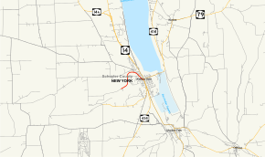
New York State Route 409 (NY 409) is a state highway in Schuyler County, New York, in the United States. It is more of a spur route as it is connected to the state highway system at only one end. It begins at a grade crossing with the Norfolk Southern Railway in the town of Dix and ends in downtown Watkins Glen at a junction with NY 14 and NY 414. Its western terminus is also the upper entrance to the gorge at Watkins Glen State Park. NY 409 is known as Station Road in Dix and as Steuben Street and West 4th Street in Watkins Glen. The route was assigned by 1970 and follows part of the original Watkins Glen Grand Prix Course.
Route description
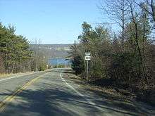
NY 409 begins at a grade crossing with the Norfolk Southern Railway in the town of Dix,[3] where maintenance of Station Road shifts from Dix to the New York State Department of Transportation.[4] The route initially heads to the northeast through an isolated rural area, running along the northern fringe of Watkins Glen State Park to the western edge of a valley overlooking Seneca Lake and the village of Watkins Glen. Here, NY 409 turns northward, slowly descending into the gorge as it crosses into the town of Reading. After 0.5 miles (0.8 km), the route curves back to the east and rapidly descends in elevation on its way into the village of Watkins Glen.[3]
Now named Steuben Street, NY 409 first meets the southern terminus of County Route 28 (CR 28), which links Watkins Glen to Hammondsport by way of CR 23. The route continues on, proceeding southeastward across residential sections of the village, bisecting several blocks of homes in the process. The route continues downhill into Watkins Glen's business district, where Steuben Street turns northeastward and becomes West 4th Street at South Madison Avenue, a north–south street serving as a divider between the village's residential and commercial districts. NY 409 ends one block later at an intersection with Franklin Street, which carries NY 14 and NY 414 through Watkins Glen. At this point, NY 414 leaves NY 14 and continues to the northeast along NY 409's right-of-way on East 4th Street.[3]
History
From 1948 to 1952, modern NY 409 was part of the Watkins Glen Grand Prix Course, a road course around Watkins Glen State Park that also included NY 329, Franklin Street (NY 14 and NY 414), and Whites Hollow Road. The first race on the road took place on October 2, 1948; the last was on September 20, 1952. During the 1952 race, a car briefly entered the crowd that had lined up along the course, killing one person and injuring several others. The race was stopped immediately and moved to another, more rural location in 1953.[5] The entirety of the old Grand Prix road course was added to the National Register of Historic Places on December 4, 2002.[6] NY 409, meanwhile, was assigned to its current alignment by 1970.[2]
Major intersections
The entire route is in Schuyler County.
| Location | mi[1] | km | Destinations | Notes | |
|---|---|---|---|---|---|
| Dix | 0.00 | 0.00 | Norfolk Southern grade crossing | ||
| Watkins Glen | 1.65 | 2.66 | |||
| 1.000 mi = 1.609 km; 1.000 km = 0.621 mi | |||||
See also
.svg.png) New York Roads portal
New York Roads portal
References
- 1 2 "2009 Traffic Volume Report for New York State" (PDF). New York State Department of Transportation. August 19, 2010. p. 229. Retrieved May 4, 2011.
- 1 2 State of New York Department of Transportation (January 1, 1970). Official Description of Touring Routes in New York State (PDF). Retrieved March 28, 2009.
- 1 2 3 Microsoft; Nokia (June 30, 2015). "overview map of NY 409" (Map). Bing Maps. Microsoft. Retrieved June 30, 2015.
- ↑ Beaver Dams Digital Raster Quadrangle (Map). 1:24,000. New York State Department of Transportation. 1978. Retrieved November 27, 2010.
- ↑ Warren, James (August 29, 2002). "National Register of Historic Places Registration: Watkins Glen Grand Prix Course, 1948–1952". New York State Office of Parks, Recreation and Historic Preservation. Retrieved February 6, 2010.
- ↑ "National Register of Historic Places Advanced Search". National Register of Historic Places. National Park Service. Retrieved February 6, 2010. The Grand Prix course is reference number 02001397.
External links
| Wikimedia Commons has media related to New York State Route 409. |
- New York State Route 409 at New York Routes • New York State Highway Termini