New York State Route 282
| ||||
|---|---|---|---|---|
|
Map of Tioga County and vicinity with NY 282 highlighted in red | ||||
| Route information | ||||
| Maintained by NYSDOT | ||||
| Length: | 3.48 mi[1] (5.60 km) | |||
| Existed: | 1930[2] – present | |||
| Major junctions | ||||
| South end: |
| |||
|
| ||||
| North end: |
| |||
| Location | ||||
| Counties: | Tioga | |||
| Highway system | ||||
| ||||

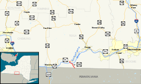
New York State Route 282 (NY 282) is a north–south state highway located within Tioga County in the Southern Tier of New York in the United States. It extends for 3.48 miles (5.60 km) from the Pennsylvania state line in the town of Nichols, where it connects to Pennsylvania Route 187 (PA 187), to an intersection with NY 17C in the town of Tioga. The route meets the Southern Tier Expressway (NY 17) and crosses over the Susquehanna River just west of the village of Nichols. NY 282 originally served the hamlet of Smithboro on the northern riverbank when it was assigned as part of the 1930 renumbering of state highways in New York. It was realigned in the 1960s to cross the river on a new bridge to the east of Smithboro.
Route description

NY 282 begins at the Pennsylvania state line in the town of Nichols, where it connects to PA 187. The route heads to the northwest as a two-lane road, loosely paralleling Wappasening Creek as it passes farmland in the base of a valley surrounding the creek. It crosses over the creek and serves little more than farms on its way into the village of Nichols, where the open fields give way to residential neighborhoods and NY 282 becomes known as Main Street. After two blocks, the highway enters Nichols' central business district, where it intersects with County Route 6 (CR 6, named River Street),[3] a highway once designated as NY 283.[4] NY 282 turns west at the junction, following West River Street through another residential section of the village to Nichols' western village limits, where the street name changes to West River Road.[3]
Just outside the village limits, the line of homes ends at an interchange with the eastbound half of the Southern Tier Expressway (NY 17). The route briefly continues west through a commercialized area of the town of Nichols, running parallel to the expressway before turning north onto an unnamed highway crossing over the Susquehanna River. At this point, West River Road becomes CR 4. Heading away from the river road, NY 282 passes under the expressway and connects to its westbound direction before crossing the river and entering the town of Tioga. It immediately passes over the Norfolk Southern Railway's Southern Tier Line on the northern riverbank before traversing a brief undeveloped area of rolling fields in the base of a valley surrounding the river. The open stretch ultimately leads to the route's end at an intersection with NY 17C on the northern edge of the valley.[3]
History
On April 27, 1922, the state of New York awarded a contract to rebuild a 4-mile (6.4 km) highway connecting the Pennsylvania state line south of the village of Nichols to the hamlet of Smithboro. The project was 98 percent done by the end of 1922[5] and completed by 1926.[6] Upon completion, the road was added to the state highway system as unsigned State Highway 1615 (SH 1615).[5] In the 1930 renumbering of state highways in New York, hundreds of state-maintained highways were assigned posted route numbers for the first time.[7] One of these was SH 1615, which was designated as NY 282.[2] The route was realigned slightly in the mid-1960s to follow a new connector across the Susquehanna River east of Smithboro.[8][9] NY 282's original alignment along the southern riverbank is now part of CR 4 while a small section in Smithboro is town-maintained and known as Bridge Street.[10]
Major intersections
The entire route is in Tioga County.
| Location | mi[1] | km | Destinations | Notes | |
|---|---|---|---|---|---|
| Nichols | 0.00 | 0.00 | Continuation into Pennsylvania | ||
| Village of Nichols | 1.91 | 3.07 | Former western terminus of NY 283 | ||
| Nichols | 2.61 | 4.20 | Exit 62 (NY 17) | ||
| Formerly part of NY 283 | |||||
| 2.96 | 4.76 | Exit 62 (NY 17) | |||
| Tioga | 3.48 | 5.60 | |||
| 1.000 mi = 1.609 km; 1.000 km = 0.621 mi | |||||
See also
.svg.png) New York Roads portal
New York Roads portal
References
- 1 2 "2008 Traffic Volume Report for New York State" (PDF). New York State Department of Transportation. June 16, 2009. p. 205. Retrieved February 1, 2010.
- 1 2 Tourist Map of Pennsylvania (PDF) (Map). Pennsylvania Department of Highways. 1930. Retrieved January 18, 2013.
- 1 2 3 Google (January 18, 2013). "overview map of NY 282" (Map). Google Maps. Google. Retrieved January 18, 2013.
- ↑ New York State Highways (Map). Cartography by Rand McNally and Company. State of New York Department of Commerce. 1969.
- 1 2 State of New York Commission of Highways (1922). Tables Giving Detailed Information and Present Status of All State, County and Federal Aid Highways. Albany, NY: J. B. Lyon Company. p. 84. Retrieved January 18, 2013.
- ↑ Official Map Showing State Highways and other important roads (Map). Cartography by Rand McNally and Company. State of New York Department of Public Works. 1926.
- ↑ Dickinson, Leon A. (January 12, 1930). "New Signs for State Highways". The New York Times. p. 136.
- ↑ Federal Highway Administration (2012). "NBI Structure Number: 1054630". National Bridge Inventory. Federal Highway Administration.
- ↑ Barton Quadrangle – New York – Tioga Co. (Map). 1:24,000. 7.5 Minute Series (Topographic). United States Geological Survey. 1976. Retrieved January 18, 2013.
- ↑ Barton Digital Raster Quadrangle (Map). 1:24,000. New York State Department of Transportation. 1994. Retrieved January 18, 2013.
External links
| Wikimedia Commons has media related to New York State Route 282. |
- New York State Route 282 at New York Routes • New York State Highway Termini