New York State Route 141
| ||||
|---|---|---|---|---|
|
Map of Westchester County in southeastern New York with NY 141 highlighted in red | ||||
| Route information | ||||
| Maintained by NYSDOT | ||||
| Length: | 3.49 mi[1] (5.62 km) | |||
| Existed: | 1930[2] – present | |||
| Major junctions | ||||
| South end: |
| |||
|
| ||||
| North end: |
| |||
| Location | ||||
| Counties: | Westchester | |||
| Highway system | ||||
| ||||

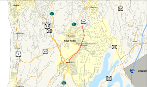
New York State Route 141 (NY 141) is a north–south state highway in Westchester County, New York, in the United States. It extends for 3.49 miles (5.62 km) from an interchange with NY 9A in the hamlet of Hawthorne to an intersection with NY 117 in the village of Pleasantville. The route has a very short overlap with NY 100 west of Hawthorne and connects to the southbound direction of the Taconic State Parkway by way of a partial interchange in Hawthorne. Most of NY 141 is a two-lane road that serves residential and commercial areas; however, the southwesternmost 0.2 miles (0.3 km) is a four-lane divided highway.
NY 141 was established in the 1930 renumbering of state highways in New York, extending from Hawthorne to Pleasantville as it does today. At one time, the route extended as far south as the hamlet of Eastview 2.5 miles (4.02 km) southwest of Hawthorne.
Route description
NY 141 begins at a trumpet interchange with NY 9A on the western edge of the hamlet of Hawthorne, located within the town of Mount Pleasant. This junction also serves as the south end of NY 9A's overlaps with NY 100. NY 141 initially heads to the northeast as an independent route, following the two ramps not carrying either direction of NY 100. After just 0.1 miles (0.2 km), all four ramps merge into a four-lane divided highway, creating a short overlap between NY 141 and NY 100. The divided highway ends at Brighton Avenue, the first road that it intersects. NY 100 splits from NY 141 here, following Brighton Avenue southward while NY 141 heads southeastward along the two-lane Broadway, passing through a lightly developed commercial area. After one block, the route intersects Bradhurst Avenue,[3] here a state-maintained street serving as a one-block spur of NY 100.[4]
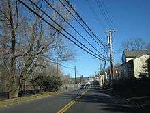
Just east of Bradhurst Avenue, NY 141 connects to the Taconic State Parkway by way of a partial interchange. The junction has only two connections; the first links NY 141 to the southbound parkway, while the second leads from the northbound direction of the parkway to NY 141 via West Cross Street. Continuing eastward, the highway passes under the parkway and enters the commercial center of Hawthorne. Here, NY 141 crosses over the Metro-North Railroad before turning northward onto Elwood Avenue. Over the next 1.5 miles (2.4 km), NY 141 closely parallels the railroad's Harlem Line, serving its Hawthorne station as the road heads north. After three blocks, the road and railroad turn to the northeast and begin to run alongside the Saw Mill River Parkway. Elwood Avenue ends shortly after the curve, giving way to Commerce Street.[3]
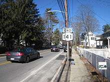
As Commerce Street, NY 141 continues to head to the northeast, passing by a line of businesses in an otherwise residential area between the hamlets of Hawthorne and Thornwood. The route eventually enters the latter's central business district, where the Saw Mill Parkway and the Harlem Line turn northwestward toward the center of the nearby village of Pleasantville. NY 141 continues on a northern track, however, becoming known as Broadway again as it heads through mostly residential areas on its way into the eastern portion of Pleasantville. It retains the Broadway name to a junction with Bedford Road, from where the route continues as Bedford Road for two blocks before ending at an intersection with NY 117. Westbound NY 117 enters from the west on Manville Road, while NY 117 east turns north to follow Bedford Road.[3]
History
The alignment of NY 141 between Fort Washington Avenue in Hawthorne and the Pleasantville village line was constructed up to state highway standards during the early 20th century. Designated State Highway 1308 (SH 1308), August 31, 1915, the State of New York let a contract to upgrade the 2.14 miles (3.44 km) alignment with new pavement. The alignment would have 16 feet (4.9 m) of pavement on 29 feet (8.8 m) of right-of-way. Construction was completed in 1918, and the state accepted the alignment into the state highway system on March 15.[5]
NY 141 was established in the 1930 renumbering of state highways in New York. It originally followed Marble Avenue from Thornwood to Pleasantville;[2] however, it was realigned in the 1940s to follow Broadway between Thornwood and NY 117, then routed on Bedford Road, in Pleasantville.[6][7] In the late 1930s, NY 141 was extended southwestward to Eastview by way of modern NY 9A and the now-dismantled Old Saw Mill River Road.[8][9] This change was reverted on January 1, 1949 when most of the highway became part of a realigned NY 9A.[10] On September 1, 1980, NY 141 was extended two blocks northward after NY 117 was rerouted to follow Manville Road through Pleasantville.[11]
Major intersections
The entire route is in Westchester County.
| Location | mi[1][12] | km | Destinations | Notes | |
|---|---|---|---|---|---|
| Mount Pleasant | 0.00 | 0.00 | |||
| 0.14 | 0.23 | Interchange; western terminus of concurrency with NY 100 | |||
| 0.22 | 0.35 | Eastern terminus of concurrency with NY 100 | |||
| 0.3 | 0.48 | Exit 2 (Taconic Parkway) | |||
| Thornwood | 2.1 | 3.4 | |||
| Pleasantville | 3.49 | 5.62 | |||
1.000 mi = 1.609 km; 1.000 km = 0.621 mi
| |||||
See also
.svg.png) New York Roads portal
New York Roads portal
References
- 1 2 "2008 Traffic Data Report for New York State" (PDF). New York State Department of Transportation. June 16, 2009. p. 249. Retrieved January 27, 2010.
- 1 2 Road Map of New York (Map). Cartography by General Drafting. Standard Oil Company of New York. 1930.
- 1 2 3 Microsoft; Nokia (November 1, 2015). "overview map of NY 141" (Map). Bing Maps. Microsoft. Retrieved November 1, 2015.
- ↑ White Plains Digital Raster Quadrangle (Map). 1:24,000. New York State Department of Transportation. 1991. Retrieved February 22, 2011.
- ↑ State of New York Commission of Highways (1922). Tables Giving Detailed Information and Present Status of All State, County and Federal Aid Highways. Albany, NY: J. B. Lyon Company. pp. 14, 34, 66. Retrieved August 2, 2013.
- ↑ Map of New York (Map). Cartography by H.M. Gousha Company. Shell Oil Company. 1940.
- ↑ New York with Pennsylvania (Map). Cartography by Rand McNally and Company. Texas Oil Company. 1946.
- ↑ Shell Road Map – New York (Map). Cartography by H.M. Gousha Company. Shell Oil Company. 1937.
- ↑ New York Info-Map (Map). Cartography by Rand McNally and Company. Gulf Oil Company. 1940.
- ↑ "State Announces Changes in County; Routes 28 and 209". The Kingston Daily Freeman. Kingston, New York. December 9, 1948. p. 1. Retrieved August 20, 2014 – via Newspapers.com.

- ↑ New York State Legislature. "New York State Highway Law § 341". Retrieved January 27, 2010.
- ↑ Google (May 26, 2015). "New York State Route 141" (Map). Google Maps. Google. Retrieved May 26, 2015.
External links
| Wikimedia Commons has media related to New York State Route 141. |
- New York State Route 141 at New York Routes • New York State Highway Termini