New York State Route 108
| ||||
|---|---|---|---|---|
| Harbor Road | ||||
|
Map of Suffolk County on Long Island with NY 108 highlighted in red | ||||
| Route information | ||||
| Maintained by NYSDOT | ||||
| Length: | 1.72 mi[1] (2.77 km) | |||
| Existed: | c. 1932[2][3] – present | |||
| Major junctions | ||||
| South end: |
| |||
| North end: |
| |||
| Location | ||||
| Counties: | Suffolk | |||
| Highway system | ||||
| ||||


New York State Route 108 (NY 108) is a 1.72-mile-long (2.77 km) north–south state highway located on the Suffolk County side of the Suffolk–Nassau county line on Long Island, New York, in the United States. It is a spur route connecting NY 25A in Cold Spring Harbor to the Cold Spring Harbor station on the Long Island Rail Road's Port Jefferson Branch via Harbor Road. Harbor Road terminates at an intersection with Woodbury Road, on the Nassau County line, which carries County Route 11 to the east and unsigned County Route 12 to the west. NY 108, assigned in the early 1930s, is the shortest state highway on Long Island.
Route description
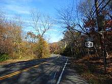
NY 108 begins at Woodbury Road at the Nassau County line in the community of Cold Spring Harbor. Woodbury Road continues east as CR 11, which later becomes Pulaski Road. To the west, Woodbury Road proceeds through Nassau County as unsigned CR 12. The road, named Harbor Road, passes to the north of the Long Island Rail Road's Cold Spring Harbor station and runs along the Nassau–Suffolk county line. The route heads northward through a small residential neighborhood. At the intersection with Stillwell Lane, NY 108 southbound crosses into Nassau County, but soon curves away back into Suffolk. Soon after, the two-lane road continues into Trail View State Park, where the route becomes desolate, passing two local ponds. A short distance later, NY 108 enters a small region of houses and intersects with Lawrence Hill Road. At the intersection with Lawrence Hill, NY 108 terminates; just westward lies at an intersection with NY 25A (North Hempstead Turnpike) in Cold Spring Harbor.[4]
History
Harbor Road was improved to state highway standards as part of a project contracted out by the state of New York on September 4, 1919. A total of 5.86 miles (9.43 km) of highway were rebuilt as part of the $205,500 project (equivalent to $2.73 million in 2016), including the westernmost 4.5 miles (7.2 km) of modern NY 25A in Suffolk County. The roads reconstructed as part of the project were added to the state highway system on January 11, 1921, as unsigned State Highway 1525 (SH 1525).[5][6] The east–west portion of SH 1525 was designated as part of NY 25 in the mid-1920s;[7][8] however, the north–south leg did not receive a posted route number until c. 1932, when it became NY 108. The alignment of NY 108 has not been altered as of 1932.[2][3]
Major intersections
The entire route is in Cold Spring Harbor, Suffolk County.
| mi[1] | km | Destinations | Notes | ||
|---|---|---|---|---|---|
| 0.00 | 0.00 | Southern terminus; western terminus of CR 11 | |||
| 1.72 | 2.77 | Northern terminus; access to NY 25A via Lawrence Hill Road | |||
| 1.000 mi = 1.609 km; 1.000 km = 0.621 mi | |||||
See also
.svg.png) New York Roads portal
New York Roads portal
References
- 1 2 "2008 Traffic Data Report for New York State" (PDF). New York State Department of Transportation. June 16, 2009. p. 242. Retrieved January 10, 2010.
- 1 2 New York (Map). Cartography by H.M. Gousha Company. Kendall Refining Company. 1931.
- 1 2 Texaco Road Map – New York (Map). Cartography by Rand McNally and Company. Texas Oil Company. 1932.
- ↑ Microsoft; Nokia (December 24, 2009). "overview map of NY 108" (Map). Bing Maps. Microsoft. Retrieved December 24, 2009.
- ↑ State of New York Commission of Highways (1922). Tables Giving Detailed Information and Present Status of All State, County and Federal Aid Highways. Albany, NY: J. B. Lyon Company. p. 78. Retrieved December 28, 2012.
- ↑ Federal Reserve Bank of Minneapolis Community Development Project. "Consumer Price Index (estimate) 1800–". Federal Reserve Bank of Minneapolis. Retrieved October 21, 2016.
- ↑ "New York's Main Highways Designated by Numbers". The New York Times. December 21, 1924. p. XX9.
- ↑ Official Map Showing State Highways and other important roads (Map). Cartography by Rand McNally and Company. State of New York Department of Public Works. 1926.
External links
| Wikimedia Commons has media related to New York State Route 108. |
- New York State Route 108 at New York Routes • New York State Highway Termini
- NY 108 (Greater New York Roads)