New Mexico State Road 528
| ||||
|---|---|---|---|---|
| Route information | ||||
| Maintained by NMDOT | ||||
| Length: | 15.355 mi[1] (24.711 km) | |||
| Major junctions | ||||
| South end: |
| |||
|
| ||||
| North end: |
| |||
| Location | ||||
| Counties: | Bernalillo, Sandoval | |||
| Highway system | ||||
| ||||

New Mexico State Road 528 is a 15.3 mi (24.6 km) long state highway in Sandoval County and Bernalillo County, New Mexico. NM 528 is signed as Alameda Blvd. In Rio Rancho, the road is also known as Pat D'Arco Highway,[2] named after former mayor of Rio Rancho Pat D'Arco.[3] It is an L-shaped route signed north-south in Sandoval County and east-west in Bernalillo County.
Route description
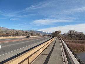
NM 528 begins at a diamond interchange with Interstate 25 (I-25) in northern Albuquerque in Bernalillo County. It then heads west along Alameda Boulevard where it intersects 2nd Street NW, which carries NM 47. The route crosses the Rio Grande and then turns to the northwest. At Coors Boulevard, it intersects NM 448. The highway then turns north and enters Rio Rancho in Sandoval County.[4]
Through Rio Rancho, NM 528, known as Pat D'Arco Highway, is a major north–south street. It serves major retailers, restaurants, and other businesses. Feeder streets which connect adjacent neighborhoods cross Pat D'Arco Highway at regular intervals. It meets NM 448 again near its own northern end. The route ends at U.S. Route 550 (US 550) on the northern edge of Rio Rancho.[4]
Major intersections
| County | Location | mi[5] | km | Destinations | Notes |
|---|---|---|---|---|---|
| Bernalillo | Albuquerque | 0.000 | 0.000 | Southern terminus at I-25 Exit 233 | |
| 1.956 | 3.148 | ||||
| 4.209 | 6.774 | ||||
| Sandoval | Rio Rancho | 10.647 | 17.135 | ||
| 15.355 | 24.711 | Northern terminus | |||
| 1.000 mi = 1.609 km; 1.000 km = 0.621 mi | |||||
See also
 U.S. Roads portal
 New Mexico portal
References
- ↑ "Posted Route–Legal Description" (PDF). New Mexico Department of Transportation. March 16, 2010. pp. 97–98. Retrieved December 18, 2013.
- ↑ The Official Site of Rio Rancho, NM - City Hall
- ↑ State Transportation Commission Names Section of NM 528 After Former Rio Rancho Mayor Pat D’Arco
- 1 2 Google (August 7, 2011). "New Mexico State Road 528" (Map). Google Maps. Google. Retrieved August 7, 2011.
- ↑ "TIMS Road Segments by Posted Route/Point with AADT Info; NM, NMX-Routes" (PDF). New Mexico Department of Transportation. April 3, 2013. pp. 63–65. Retrieved December 18, 2013.
External links
![]() Geographic data related to New Mexico State Road 528 at OpenStreetMap
Geographic data related to New Mexico State Road 528 at OpenStreetMap