New Jersey Route 7
| ||||
|---|---|---|---|---|
 | ||||
| Route information | ||||
| Maintained by NJDOT, Township of Nutley, and Passaic County | ||||
| Length: | 9.46 mi[1] (15.22 km) | |||
| Existed: | 1927 – present | |||
| Southern section | ||||
| Length: | 5.35 mi[1] (8.61 km) | |||
| East end: |
| |||
| Major junctions: |
| |||
| West end: |
| |||
| Northern section | ||||
| Length: | 4.11 mi[1] (6.61 km) | |||
| South end: | Newark/Belleville border | |||
| North end: | Nutley/Clifton border | |||
| Location | ||||
| Counties: | Hudson, Bergen, Essex, Passaic | |||
| Highway system | ||||
| ||||

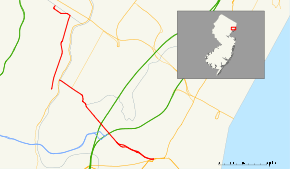
Route 7 is a state highway in the northern part of New Jersey in the United States. It has two sections, an east–west alignment running from U.S. Route 1/9 Truck in Jersey City to Route 21 in Belleville, and a north–south alignment running from the Newark/Belleville to the Nutley/Clifton border. The New Jersey Department of Transportation lists Route 7 as a single north–south highway with a small gap between the alignments. The entire highway has a combined length of 9.46 mi (15.22 km).
The southern section of Route 7, which runs from Jersey City to Belleville, passes through industrial areas, the New Jersey Meadowlands, Arlington Memorial Park, and some residential and business areas. West of the interchange with County Route 508 in Kearny, Route 7 is the Belleville Turnpike, a historic road created in 1759. The northern section of Route 7 runs north through residential and business areas of Belleville and Nutley into Clifton, where it turns west and crosses back into Nutley, briefly turning to the north to come to its northern terminus. A portion of the route in Nutley is municipally maintained while the portion within Clifton is maintained by Passaic County. The two separate sections of Route 7 are linked by County Route 506 (Rutgers Street) in Belleville, which is signed as Route 7 despite the fact it is not officially part of the route.
Route 7 was established in 1927 to run from Jersey City to Paterson, replacing Pre-1927 Route 11 between Belleville and Paterson. The routing was amended in 1929 to head to Route 3 in Wallington and was extended north to Route 6 (now U.S. Route 46) in East Paterson in 1949. In 1953, the route was modified to follow its current alignment.
Route description
Southern section
The first section of Route 7 begins at an intersection with U.S. Route 1-9 Truck and County Route 645 (Charlotte Avenue) in Jersey City, Hudson County, heading to the west on a four-lane highway that is signed east–west.[1] The route crosses the Hackensack River on the Wittpenn Bridge into Kearny. Route 7 interchanges with County Route 659 (Fish House Road) and widens to a six-lane divided highway. The route than passes by industrial areas and a railroad yard and then interchanges with County Route 508.[1][2] Past this interchange, Route 7 becomes the four-lane, divided Belleville Turnpike, with the eastern end of the Newark Turnpike running in the division between the two sides of Route 7. It then becomes an undivided two-lane road, heading northwest, narrowing to two lanes before it passes through the New Jersey Meadowlands, under the mainline of the New Jersey Turnpike (Interstate 95) and then the western spur of the New Jersey Turnpike a short distance later.[1][2]
Route 7 continues northwest, widens, with a painted media, as it passes through two large cemeteries on the border of Hudson County (Kearny) to the south and Bergen County (North Arlington) to the north, though the route itself is signed north–south along that border.[3]
After an intersection with Schuyler Avenue (which runs as Hudson County Route 507 to the south of Route 7 and Bergen County Route 130 to the north of Route 7), the road turns NNW, narrowing again to two lanes undivided. In this portion of the route, it had a concurrency with County Route 507 (both Bergen and Hudson counties). It keeps this configuration for about a half mile, as it still runs along the Kearny/North Arlington border. At that point, it meets the southern terminus of State Route 17 (Ridge Road) and the northern terminus of Hudson County Route 697 (Kearny Avenue).[1][2]
Past this intersection, County Route 507 turns away from Route 7, becoming concurrent with Route 17. by heading north on River Road, while Route 7 continues along Bellevill Turnpike for another half mile,Route 7 continues another half mile west, crossing the Passaic River on a lift bridge, known as the Belleville Turnpike Bridge or Rutgers Street Bridge, into Belleville, Essex County, where the local street name changes from Belleville Turnpike to Rutgers Street. The first section of Route 7 ends at an intersection with Main Street underneath Route 21.[1][2]
Gap in the route
The intersection of Main St and Rutgers Street in Belleville forms the end of one section of Route 7 (signed north, directionally west). Rutgers Street is named for Colonel Henry Rutgers, an American Revolutionary War hero and benefactor of what is now Rutgers University. For its entire length, Rutgers carries Essex County Route 506, which ends, like Rutgers Street itself, at the Rutgers Street Bridge.[1][2]
Prior to turning onto Rutgers Street, CR-506 runs along Washington Street concurrent with the northern section of Route 7. Though the northern section of Route 7 begins a few blocks south, it is not readily recognized (minimal signing). As CR-506 runs concurrently with it here, and then turns down Rutgers for the short distance that bridges the gap between the two Route 7 sections, Rutgers/506 is often viewed as if it continues Route 7, while the short portion of the northern section that lies south of Rutgers is sometimes seen as a spur, even though it is part of the main route.[1][2]
Rutgers' identity has become so closely aligned with Route 7, that though it is not officially part of Route 7, Rutgers, from Washington Avenue to Main Street, is signed as if it is part of Route 7.[1][2]
Northern section
The second section of Route 7, designated a north–south road, heads north on Washington Avenue from the Second River crossing on the Newark/Belleville border, passing through a business district.[4] The route intersects County Route 506 (Belleville Avenue), and that county route then forms a concurrency with Route 7 along the next block of Washington Avenue, to the intersection with Rutgers Street. At that point, County Route 506 heads to the east, ending at the intersection of Main Street, Rutgers Street, and bridge to Belleville (which is also the other section of Route 7).[1]
Route 7 is not signed on Washington Avenue between the Second River bridge and Rutgers Street, except on some overhead signs suspended from traffic signals.[4]
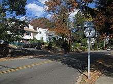
From the Rutgers Street intersection, Route 7 continues along Washington Avenue for about a mile and a half before reaching Nutley, still continuing on Washington Avenue into Nutley.[1] At the intersection with County Route 646 (Park Avenue), Route 7 turns into a municipally maintained road and enters a more residential area.[1][4] Upon intersecting County Route 606 (Kingsland Road), Route 7 crosses into Clifton, Passaic County and heads to the west on county-maintained Kingsland Street signed east–west.[1][4] Kingsland, carrying Route 7, crosses back into Nutley, regaining state maintenance. When Kingsand becomes County Route 644 at the intersection with Cathedral Avenue, Route 7 turns north from Kingsland onto Cathedral Avenue and comes to its terminus at Orange St in Nutley. However, signage continues to indicate Route 7 up to the terminus of Cathedral Avenue at interchange with Route 3 at the intersection of Cathedral Avenue, Passaic Avenue, and Ward Avenue.[1]
History

The Belleville Turnpike, which is the majority of the southern portion of Route 7, was created in 1759 as a turnpike made out of cedar logs. This road was chartered in 1808.[5][6] It served as a part of the Underground Railroad route for escaped slaves to get to Jersey City.[7]
The northern segment of Route 7 was originally a part of Pre-1927 Route 11, which was legislated in 1917 to run from Newark to Paterson.[8] In the 1927 New Jersey state highway renumbering, Route 7 was designated to run from Jersey City to Paterson, replacing Pre-1927 Route 11 between Belleville and Paterson.[9][10]
.svg.png)
In 1929, the routing was amended to run from Route 25 (now U.S. Route 1/9 Truck) in Jersey City to Route 3 in Wallington.[11] Route 7 was extended north in 1949 to continue to Route 6 (now U.S. Route 46) in East Paterson (now Elmwood Park).[12]
In the 1953 New Jersey state highway renumbering, Route 7 was legislated onto its current alignment, with the northern terminus moved to the Nutley/Clifton border.[13] The route was also realigned to head south on Washington Avenue between the Newark border and Rutgers Street in Belleville on what was Route 11N, a remnant of Pre-1927 Route 11, making Route 7 discontinuous.[14] County Route 506 used to follow the southern portion of Route 7 but has been truncated to the intersection with Routes 7 and 21 in Belleville.[15]
Major intersections
Southern section
| County | Location | mi[1] | km | Destinations | Notes |
|---|---|---|---|---|---|
| Hudson | Jersey City | 0.00 | 0.00 | Eastern terminus | |
| Hackensack River | 0.42 | 0.68 | Wittpenn Bridge | ||
| Kearny | 0.56 | 0.90 | Fish House Road (CR 659 west) | Interchange | |
| 1.40 | 2.25 | Interchange | |||
| Hudson–Bergen county line | Kearny–North Arlington line | 4.22 | 6.79 | South end of CR 507 overlap | |
| 4.74 | 7.63 | ||||
| 5.22 | 8.40 | North end of CR 507 overlap | |||
| Passaic River | 5.32 | 8.56 | Belleville Turnpike Bridge | ||
| Essex | Belleville | 5.35 | 8.61 | Interchange; Northern terminus of first section, CR 506 signed as Route 7 connection to northern section | |
1.000 mi = 1.609 km; 1.000 km = 0.621 mi
| |||||
Northern section
| County | Location | mi[1] | km | Destinations | Notes |
|---|---|---|---|---|---|
| Essex | Belleville | 6.05 | 9.74 | Newark/Belleville border | Southern terminus of second section |
| 6.40 | 10.30 | South end of CR 506 overlap | |||
| 6.48 | 10.43 | North end of CR 506 overlap, CR 506 signed as Route 7 connection to southern section | |||
| Passaic | Clifton | No major junctions | |||
| Essex | Nutley | 10.16 | 16.35 | Nutley/Clifton border | Northern terminus |
1.000 mi = 1.609 km; 1.000 km = 0.621 mi
| |||||
See also
 U.S. Roads portal
 New Jersey portal
References
- 1 2 3 4 5 6 7 8 9 10 11 12 13 14 15 16 17 18 "Route 7 straight line diagram" (PDF). New Jersey Department of Transportation. Retrieved 2008-11-10.
- 1 2 3 4 5 6 7 Google (2009-04-01). "overview of New Jersey Route 7 southern section" (Map). Google Maps. Google. Retrieved 2009-04-01.
- ↑ Google (2008-11-14). "Belleville Turnpike and Schuyler Avenue, North Arlington, NJ" (Map). Google Maps. Google. Retrieved 2008-11-14.
- 1 2 3 4 Google (2009-04-01). "overview of New Jersey Route 7 northern section" (Map). Google Maps. Google. Retrieved 2009-04-01.
- ↑ "Town of Kearny History". Town of Kearny. Archived from the original on May 4, 2008. Retrieved 2008-11-11.
- ↑ Murphy, John L. Index of Colonial and State Laws Between the Years 1663 and 1877 Inclusive. Stare of New Jersey. Retrieved 2008-11-11.
- ↑ Wiggins, Genene P. (March 14, 1994). "Danger-filled path to freedom led slaves through Jersey City". Jersey Journal. Retrieved 2008-11-11.
- ↑ Annual Report. New Jersey State Highway Department. 1917.
- ↑ State of New Jersey, Laws of 1927, Chapter 319.
- ↑ 1927 New Jersey Road Map (Map). State of New Jersey. Retrieved 2008-10-08.
- ↑ State of New Jersey, Laws of 1929, Chapter 126.
- ↑ State of New Jersey, Laws of 1949, Chapter 175.
- ↑ "1953 renumbering". New Jersey Department of Highways. Retrieved July 31, 2009.
- ↑ State of New Jersey, Laws of 1939, complied.
- ↑ Hudson County Road Map – Sheet 2 (Map). Rutgers University Cartography Services. 1965. Retrieved 2008-11-12.
External links
| Wikimedia Commons has media related to New Jersey Route 7. |
- New Jersey Roads: Route 7
- New Jersey Highway Ends: Route 7
- An expanded view of road jurisdiction near the confluence of US 46, I-95 / NJTurnpike, I 280, NJ 7 and CR 508 in Kearny
- Speed Limits for Route 7