New Jersey Route 413
| ||||
|---|---|---|---|---|
 | ||||
| Route information | ||||
| Maintained by Burlington County Bridge Commission | ||||
| Length: | 0.76 mi[1] (1.22 km) | |||
| Existed: | January 1, 1953 – present | |||
| Major junctions | ||||
| West end: |
| |||
| East end: |
| |||
| Location | ||||
| Counties: | Burlington | |||
| Highway system | ||||
| ||||

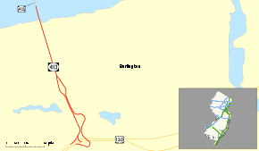
Route 413 is a 0.76-mile (1.22 km) long state highway in New Jersey, United States. It is an eastward extension into New Jersey of the longer Pennsylvania Route 413. The western terminus is in Burlington in the middle of the Burlington–Bristol Bridge crossing of the Delaware River at the New Jersey–Pennsylvania state border; the eastern terminus is at an intersection with U.S. Route 130. Despite the east–west orientation, Route 413 runs north–south, but PA Route 413 is signed north–south. Prior to the 1953 renumbering, Route 413 was Route S25, a prefixed spur of Route 25.
Route description

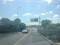
New Jersey Route 413 begins at the state line, midway along the Burlington–Bristol Bridge, as a continuation of Pennsylvania State Route 413. The highway heads northward, heading along Reed Street, and there is an intersection with Delaware Avenue West, and soon after, intersections with West Pearl Street, and a local highway. Passing a few residences, Route 413 intersects with West Pearl Street, and enters a more commercial type of region. The next intersection with Brown Street is jammed with houses, and nearby is a large parking lot.[2]
At the intersection with Veterans Drive and Conover Street, Route 413 splits into a divided highway, and the highway intersects with West Broad Street. After West Broad Street, Route 413 merges back in, passing several more commercial buildings and heading into John Fitzgerald Kennedy Park. The route parallels to the east of Washington Street, where it heads into a roundabout and terminates at an intersection with U.S. Route 130 (Camden Avenue) in Burlington.[2]
History
.svg.png)
In the 1927 renumbering of highways in New Jersey, U.S. Route 130 was assigned as a part of New Jersey State Highway Route 25, which made up U.S. Route 1 and U.S. Route 9 as well. During that renumbering in 1927, Route 413 was originally New Jersey State Highway Route S-25, a prefixed spur of State Highway Route 25. The highway remained intact along its alignment in Keim Road to the Burlington–Bristol Bridge until January 1, 1953.[3]
On January 1, 1953, the New Jersey State Highway Department performed a second renumbering of state highways. State Highway Route 25, which had run at the southern terminus with Route 130, was decommissioned for the sole designation. Since State Highway Route 25 was decommissioned, State Highway Route S-25 would be orphaned and was decommissioned that day. The Highway Department renumbered S-25's alignment to NJ 413, which continued as Pennsylvania Route 413.[4]
Major intersections
| County | Location | mi[1] | km | Destinations | Notes |
|---|---|---|---|---|---|
| Bucks | Bristol Township | 0.00 | 0.00 | Pennsylvania state line | |
| Delaware River | 0.00 | 0.00 | Burlington-Bristol Bridge (Westbound toll, cash or E-ZPass) | ||
| Burlington | Burlington | 0.76 | 1.22 | ||
1.000 mi = 1.609 km; 1.000 km = 0.621 mi
| |||||
See also
 U.S. Roads portal
 New Jersey portal
- New Jersey Route 25
References
- 1 2 "New Jersey Route 413 straight line diagram" (PDF). New Jersey Department of Transportation. 2008. Retrieved 2009-03-09.
- 1 2 Microsoft; Nokia (October 28, 2015). "overview map of NJ 413" (Map). Bing Maps. Microsoft. Retrieved October 28, 2015.
- ↑ State of New Jersey, Laws of 1927, Chapter 319.
- ↑ "1953 renumbering". New Jersey Department of Highways. Retrieved July 31, 2009.
External links
 Media related to New Jersey Route 413 at Wikimedia Commons
- Alps's Roads - NJ 413 images
- New Jersey Highway Ends: Route 413