New Hampshire Route 47
| ||||
|---|---|---|---|---|
|
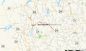
Map of Hillsborough County in southern New Hampshire with NH 47 highlighted in red | ||||
| Route information | ||||
| Maintained by NHDOT | ||||
| Length: | 7.148 mi[1] (11.504 km) | |||
| Major junctions | ||||
| South end: |
| |||
| North end: |
| |||
| Location | ||||
| Counties: | Hillsborough | |||
| Highway system | ||||
| ||||

New Hampshire Route 47 (abbreviated NH 47) is a 7.148-mile-long (11.504 km) state highway in southern New Hampshire. It runs from Francestown to Bennington. It is signed as a north–south route, but follows more of an east–west routing. In fact, during its "northernmost" (westernmost) 2.4 miles, it proceeds southwest while signed north (and vice versa).
NH 47 essentially functions as a northern bypass of New Hampshire Route 31 and New Hampshire Route 136, which pass through (and intersect in) Greenfield. Between this intersection and NH 47's endpoints, the three routes form a complete loop.
Route description
NH 47 begins at an intersection with NH 136 in Francestown. It proceeds generally northwest out of town and crosses into Bennington. The route reaches its northernmost point about two miles east of town, before turning southwest (while still signed northbound) for the remainder of its route. NH 47 ends at the intersection with NH 31 in the center of town.
Junction list
The entire route is in Hillsborough County. [1][2]
| Location[1][2] | mi[1][2] | km | Destinations | Notes | |
|---|---|---|---|---|---|
| Francestown | 0.000 | 0.000 | Southern terminus | ||
| Bennington | 7.148 | 11.504 | Northern terminus | ||
1.000 mi = 1.609 km; 1.000 km = 0.621 mi
| |||||
Road names
Route 47 uses the following local road names:
- Bennington
- Pierce Road
- School Street
- Francestown Road
- Francestown
- Bennington Road
- Second New Hampshire Turnpike
- Main Street
References
- 1 2 3 4 Bureau of Planning & Community Assistance (February 20, 2015). "NH Public Roads". Concord, New Hampshire: New Hampshire Department of Transportation. Retrieved April 7, 2015.
- 1 2 3 Bureau of Planning & Community Assistance (April 3, 2015). "Nodal Reference 2015, State of New Hampshire". New Hampshire Department of Transportation. Retrieved April 7, 2015.