New Almaden
|
New Almaden | |
|
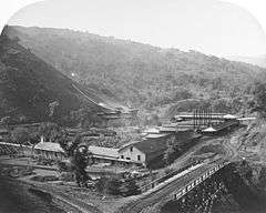
New Almaden Smelting Works, 1863. Photo: Carleton Watkins | |
 | |
| Nearest city | San Jose, California |
|---|---|
| Coordinates | 37°10′48″N 121°50′8″W / 37.18000°N 121.83556°WCoordinates: 37°10′48″N 121°50′8″W / 37.18000°N 121.83556°W |
| Area | 3,200 acres (1,300 ha) |
| Built | 1854 |
| NRHP Reference # | 66000236[1] |
| CHISL # | 339 and 339-1[2] |
| Significant dates | |
| Added to NRHP | October 15, 1966[1] |
| Designated NHL | July 4, 1961[3] |
The New Almaden quicksilver mine in the Capitancillas range in Santa Clara County, California, United States, is the oldest and most productive quicksilver (i.e., mercury) mine in the U.S.[4][5] The site was known to the Ohlone for its cinnabar long before a Mexican settler became aware of the ores in 1820. By the time they were identified as mercury, the mine was perfectly timed to supply the California Gold Rush.[6] The mine ran intermittently after 1927 and eventually closed. It was purchased by the county and is now part of Almaden Quicksilver County Park.
History
Cinnabar, bright red mercury ore, was used by the Ohlone people for paint. Andres Castillero, a captain in the Mexican Army, obtained a grant to the mine in 1846 but, occupied with his military duties during the Mexican War, soon sold it to Barron, Forbes Company, an English textile firm based in Tepic, Mexico. It was named "Nueva Almaden" by Alexander Forbes.[7] Castillero's mining claim was confirmed by the Board of Commissioners that evaluated private land claims in California on January 8, 1856, but there was continued litigation in the District court, The United States vs. Andres Castillero.[8] A claim of fraud was made on behalf of the Quicksilver Mining Company, which had acquired a competing land claim originating in an agricultural claim to the land the mine was on. On appeal to the Supreme Court of the United States the claim was found invalid in a decision rendered March 10, 1863.[9] One of the competing land claims was Rancho Los Capitancillos.[10][11][12][13][14]
The mine is named for a mercury mine in (old) Almadén, Spain, which had operated since at least Roman times. The term Almadén, meaning "the mine".,[15] is derived from the Arabic language through medieval Islamic Spain.
In 1863, acting on information that title to the mine had not been proven, Abraham Lincoln attempted to seize the mine, but the federal agent and deputy federal marshal were met at the mine gates by armed miners. Mindful of the possibility of losing the loyalty of California during the Civil War, the federal government backed off[16] and Barron, Forbes Company was allowed to sell it to American investors for $1.75 million.[17][18]
Arthur De Wint Foote worked at New Almaden in the late 1870s under James Butterworth Randol.[19]
Representations of historical life at the New Almaden Mine were drawn in vivid detail by Mary Hallock Foote, the wife of Arthur DeWint Foote, the resident engineer from 1876. Her illustrated correspondence about New Almaden, "A California Mining Camp", appeared in the February 1878 issue of Scribner's Monthly.[20] New Almaden also features prominently in her memoir A Victorian Gentlewoman in the Far West, which was later fictionalized by Wallace Stegner in his novel Angle of Repose.
Geology
The mineralized area in the Almaden mining district where the New Almaden and the nearby Guadalupe mine are located is within the large Franciscan Assemblage associated with the Coast Range. Quicksilver ore deposited by hydrothermal deposition of cinnabar from deep within the earth is found in a gangue of silica-carbonate rock formed locally by hydrothermal alteration of serpentine. The Guadalupe mine produced about 10% as much mercury as the New Almaden. There are several smaller mines in the mining district, but their ore production was not significant. The only significant quicksilver ore is cinnabar; other sulfides are present in small quantities. Mining, other than a single placer deposit of cinnabar, was underground. There is a high probability of undiscovered high-grade ore which could be found and exploited using modern techniques.[7]
Environment
Mining operations resulted in mercury pollution of the Guadalupe River and South San Francisco Bay, impacting birds and aquatic species. Responsible parties have agreed to a settlement of approximately US$6,750,822 for restoration projects.[21]
Modern times
The entrances to the mines are closed off. After being identified as a Superfund site and after subsequent containment activities, the mining area can now be visited as part of the Santa Clara County Almaden Quicksilver County Park. It was declared a National Historic Landmark in 1961.[3] By the time Santa Clara County bought the mines in 1976 and ended operations, 1,137,727 flasks (A flask is a 76-pound (34.46 kg) unit of mass used to measure liquid mercury) totaling 83,974,076 pounds (38,090 metric tons) of mercury (worth more than US$70 million) had been extracted.[22]
The remains of a variety of structures left over from the 135 years of mining activity, including housing for the up to 1,800 miners, are scattered about the park, with the biggest concentration at what was known as English Camp, established by Cornish miners in the 1860s. Some structures were built later by the U.S. Army Corps of Engineers and there is a memorial honoring the Civilian Conservation Corps firefighters who were stationed there for a time.
Two California Historical Landmark markers honor New Almaden Mine: #339 marks a cinnabar hill where Indians gathered pigment for paint, while #339-1 is near Arroyo de los Alamitos Creek where the actual mining of ore first occurred.[2]
There is also a museum adjacent at the site.
Almaden Quicksilver County Park

Almaden Quicksilver County Park is a 4,147 acre (17 km²) park that includes the grounds of former mercury ("quicksilver") mines. The park's elevation varies greatly: the most used entrances (on the east side of the park) are less than 600 feet (183 m) above sea level, while the highest point in the park is over 1,700 feet (518 m) above sea level. During the coldest storms of the winter season, it is not uncommon for the high summits to receive a light dusting of snow (which usually melts by noon). The park is owned and managed by the County of Santa Clara and its grounds also include the Guadalupe Reservoir; adjacent to the park is the Almaden Reservoir. The Casa Grande Almaden Quicksilver Mining Museum is located nearby.
Conversion from mines to park
In the period 1976 to 1978 the county developed a number of new large parks in rapid succession including Grant Ranch Park, Sanborn Park and Almaden Quicksilver County Park. Very soon after buying the mining property in 1976, Santa Clara County began planning for park usage, in an era where the county parks program was aggressively expanding.
The county parks director envisioned a historic park where visitors could experience the mining past and also enjoy the biodiversity of the natural setting. Facilities plans were created[23] and an Environmental Impact Report was prepared.[24]
Principal issues assessed in the park proposal:
- biological impacts upon habitat by park users
- water quality impacts to creeks draining the watershed
- visual and drainage impacts of road improvements
- historical analysis of mine usage
New Almaden Quicksilver Mining Museum

The New Almaden Quicksilver Mining Museum is located in the Casa Grande (big house) at 21350 Almaden Road in New Almaden. La Case Grande, an 1854 revival-style mansion designed and built by architect Francis Meyers, was the official residence and office of the mine superintendents, as well as a country retreat for wealthy mine investors. The mansion now serves as the site of the New Almaden Quicksilver Mining Museum, which contains exhibits about the history of mercury mining and the cultural history of the mining communities at New Almaden. The exhibits include a mine diorama of the interior of a mine shaft, mining equipment and technology, a mine manager's office with period displays, and artifacts from Cornish, Mexican and Chinese mining families.
See also
References
- 1 2 National Park Service (2010-07-09). "National Register Information System". National Register of Historic Places. National Park Service.
- 1 2 "California Historical Landmark: Santa Clara County". Office of Historic Preservation. California State Parks. Retrieved 2012-10-14.
- 1 2 "New Almaden". National Historic Landmark summary listing. National Park Service. Retrieved 2008-01-17.
- ↑ Snell, Charles W. (April 24, 1964). "New Almaden" (PDF). Nantional Survey of Historic Sites and Buildings (Revised). National Park Service.
- ↑ "New Almaden" (PDF). Photographs. National Park Service.
- ↑ NPS Santa Clara guide
- 1 2 Edgar Herbert Bailey, Donald Lough Everhart Geology and quicksilver deposits of the New Almaden district, Santa Clara County, California Professional Paper 360 USGS
- ↑ "The United States vs. Andres Castillero : "New Almaden" : transcript of the record (1859)". United States. District Court (California : Northern District). 1859. Retrieved January 9, 2015.
- ↑ "THE U.S. SUPREME COURT.; Decision in the New-Almaden Case--Prize Cases--Close of the Term.". The New York Times. March 11, 1863. Retrieved January 9, 2015.
- ↑ United States. District Court (California : Northern District) Land Case 132 ND
- ↑ United States v. Fossat, U.S. Supreme Court, 61 U.S. 20 How. 413 413 (1857)
- ↑ United States v. Fossat, U.S. Supreme Court, 62 U.S. 21 How. 445 445 (1858)
- ↑ Report of the Surveyor General 1844 - 1886
- ↑ The Fossat or Quicksilver Mine Case, U.S. Supreme Court, 69 U.S. 2 Wall. 649 649 (1864)
- ↑ Gudde, Erwin; William Bright (2004) California Place Names (Fourth ed. ed.). University of California Press. p. 9. ISBN 0-520-24217-3
- ↑ "The Almaden Mine Case.; THE ORDER OF SEIZURE BY GOVERNMENT REVOKED.". The New York Times. August 16, 1863. Retrieved January 9, 2015.
From the San Francisco Bulletin, July 18
- ↑ Martin Cheek (January 18, 2012) [First published in 2005]. "Lincoln and the South Valley". Gilroy Dispatch. Retrieved January 8, 2015.
- ↑ Leonard Ascher (March 1936). "Lincoln's Administration and the New Almaden Scandal". Pacific Historical Review. University of California Press. 5 (1): 38–51. doi:10.2307/3633317. JSTOR 3633317.
- ↑ Rickard, Thomas Arthur (1992). Interviews with Mining Engineers. Mini. p. 172.
- ↑ Foote, Mary Hallock (February 1878). "A California Mining Camp". Cornell University Digital Library. Scribner's Monthly. pp. 480–494. Retrieved January 8, 2015.
- ↑ "New Almaden Mine CERCLA Site". California Department of Fish and Wildlife - Office of Spill Prevention and Response. Retrieved January 8, 2015.
LOCATION: Guadalupe River and South San Francisco Bay, Santa Clara County
- ↑ Martin Cheek, "Mercury Uprising," San Jose Magazine 9, no. 1 (January 2006): 80-85
- ↑ Almaden Quicksilver Master Plan, County of Santa Clara, San Jose, California (1976)
- ↑ David Crimp, Leda Patmore, C. Michael Hogan, Harry Seidman and Vivian Paparigian, Final Environmental Impact Report, Almaden Quicksilver Park, prepared by Earth Metrics Inc. for the Santa Clara County Parks and Recreation Department (1976)
- Jose Pitti; Antonia Castaneda & Carlos Cortes (December 1988). "Five Views: An Ethnic Historic Site Survey for California / Mexican Americans in California / Historic Sites / Spanishtown Site, New Almaden, Santa Clara County". National Park Service. Retrieved 2008-01-17.
Further reading
- Jimmie Schneider, Quicksilver: The Complete History of Santa Clara County's New Almaden Mine, Zella Schneider Pub (November 1992), hardcover, 178 pages, ISBN 0963457705 ISBN 978-0963457707
- Edgar Herbert Bailey, Donald Lough Everhart Geology and quicksilver deposits of the New Almaden district, Santa Clara County, California Professional Paper 360 USGS
External links
| Wikimedia Commons has media related to Almaden Mine, Santa Clara County. |
- Almaden Quicksilver County Park
- Volunteer Organization supporting the Park, includes more information about the park and museum
- Historic American Buildings Survey (HABS) No. CA-114, "New Almaden Quicksilver Mine", 16 photos, 17 measured drawings, 15 data pages, 2 photo caption pages
- The Quicksilver Mines of New Almaden and Henriquita - Chapter 6 of "Scenes of Wonder and Curiosity in California" (1862) by James Mason Hutchings - description of life and operations at the mine site during the 1860s
- Guide to the Papers Relating to Quicksilver Mining, (ca. 1849-1894) at The Bancroft Library
- New Almaden Mine (Calif.) Collection, 1845-1973 housed at Stanford University Libraries
| Topics | |
|---|---|
| Lists by states |
|
| Lists by insular areas | |
| Lists by associated states | |
| Other areas | |
| |