Nevada State Route 164
| ||||
|---|---|---|---|---|
| Nipton Road | ||||
|
Nevada State Route 164, highlighted in red | ||||
| Route information | ||||
| Maintained by NDOT | ||||
| Length: | 18.600 mi[1] (29.934 km) | |||
| Existed: | 1976 – present | |||
| Major junctions | ||||
| West end: | CA state line near Nipton, CA | |||
| East end: |
| |||
| Location | ||||
| Counties: | Clark | |||
| Highway system | ||||
| ||||

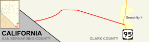
State Route 164 (SR 164) is a state highway in southern Clark County, Nevada. The route, along with an unnumbered California road, connects U.S. Route 95 (US 95) in Nevada to Interstate 15 in California just south of Primm, via the small town of Nipton, California. The highway is also known as Nipton Road.
Route description
The route begins at the California-Nevada state line about 3 miles (4.8 km) east of Nipton. The highway treks east from there, curving slightly northeast to pass by the McCullough Range. At the northern tip of the mountains surrounding Crescent Peak, the highway turns slightly more southeast and decreases in elevation as it heads towards Searchlight, Nevada. SR 164 reaches its eastern terminus at the junction with US 95 in the center of Searchlight; however, the roadway continues east as Cottonwood Cove Road, entering the Lake Mead National Recreation Area and ending near Cottonwood Cove.
_in_Clark_County%2C_Nevada.jpg)

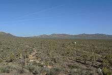
In 2003, a sign near Searchlight designated the route as the Joshua Tree Highway, due to the abundance of Joshua trees located along the roadway.
History
The highway connecting Searchlight to Nipton first appears on maps as a county road in 1933.[2] By 1940, the unimproved road was designated State Route 68.[3] The road had been graded by 1950 and was finally paved by 1963.[4][5]
In 1976, the Nevada Department of Transportation began a project to simplify and renumber the state highway system. During this process, the road was reassigned to State Route 164.[6] The route has been largely unchanged since.
Major intersections
The entire route is in Clark County.
| Location | mi | km | Destinations | Notes | |
|---|---|---|---|---|---|
| | 0.00 | 0.00 | Nipton Road – Nipton | Continuation beyond California state line | |
| Searchlight | 18.60 | 29.93 | |||
| 1.000 mi = 1.609 km; 1.000 km = 0.621 mi | |||||
See also
 Nevada portal
 U.S. Roads portal
References
| Wikimedia Commons has media related to Nevada State Route 164. |
- ↑ Nevada Department of Transportation. "Nevada State Maintained Highways, Descriptions, Index and Maps, January 2008". Retrieved 2008-06-08.
- ↑ Official Road Map of Nevada (Map). Nevada Department of Highways. 1934. Retrieved 2008-06-08.
- ↑ Official Road Map of the State of Nevada (Map). Nevada Department of Highways. 1940. Retrieved 2008-06-08.
- ↑ Official Highway Map of Nevada (Map). Nevada Department of Highways. 1950. Retrieved 2008-06-08.
- ↑ Official Highway Map of Nevada (Map). Nevada Department of Highways. 1963–64. Retrieved 2008-06-08.
- ↑ Official Highway Map of Nevada (Map). Nevada State Highway Department. 1978–79. Retrieved 2008-06-08.