Nevada State Route 579
| ||||
|---|---|---|---|---|
| Bonanza Road | ||||
| Route information | ||||
| Maintained by NDOT | ||||
| Length: | 2.206 mi[1] (3.550 km) | |||
| Existed: | 1976 – present | |||
| Major junctions | ||||
| West end: |
| |||
| East end: | Las Vegas Boulevard in Las Vegas | |||
| Highway system | ||||
| ||||

State Route 579 (SR 579) is a state highway in Clark County, Nevada. It follows a portion of Bonanza Road near the downtown area of Las Vegas. The route encompasses a small portion of former State Route 5 and the entirety of former State Route 5A, and also carried U.S. Route 95 (US 95) before it was relocated to its present freeway alignment.
Route description
_in_Las_Vegas%2C_Nevada.jpg)
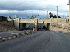
State Route 579 begins at the junction of Bonanza Road and Rancho Drive (SR 599, US 95 Business). From there, the highway heads east along Bonanza Road, traveling past various business including the offices of the Las Vegas Review Journal newspaper. SR 579 passes underneath Interstate 15 and the Union Pacific railroad tracks (at the Clark Avenue Railroad Underpass) as it parallels US 95. The road then curves slightly southeast, aligning with the downtown street grid as it intersects Main Street. Bonanza Road then passes by various City of Las Vegas buildings, including the municipal pool and Las Vegas Fire & Rescue headquarters. State Route 579 ends at the intersection of Bonanza Road and Las Vegas Boulevard (former SR 604).[1][2]
History
State Route 5, established by 1929, was a major Nevada route connecting south-central Nevada near Goldfield to the southern tip of the state via Las Vegas.[3] That route traveled on what is now SR 579 between Rancho Drive and Main Street, comprising about 1.9 miles (3.1 km) of Bonanza Road. State Route 5A was also established along Bonanza Road by 1952; it followed the approximately 0.36 miles (0.58 km) of Bonanza Road between Main Street and Fifth Street (now Las Vegas Boulevard).[4]
When US 95 was extended through Nevada in 1940, it was routed along many existing highways in Nevada, the longest of those routes being State Route 5.[5] Thus, US 95 followed the Bonanza Road segment of SR 5 segment beginning in 1940. By 1968, the Las Vegas Expressway, a new facility designed to move traffic west of downtown, was beginning to take shape.[6] By 1982 at the latest, US 95 was removed completely from Bonanza Road/SR 5 and onto the new expressway.[7]
SR 5 and SR 5A were affected by the renumbering of Nevada's state highways that began on July 1, 1976. At that time, those two designations were removed from the state highway system. In the process, State Route 579 was established along the portions of Bonanza Road previously covered by the old highway routes.[8]
Major intersections
The entire route is in Las Vegas, Clark County.
| mi | km | Destinations | Notes | ||
|---|---|---|---|---|---|
| Main Street | former SR 601 | ||||
| Las Vegas Boulevard | former SR 604 | ||||
| 1.000 mi = 1.609 km; 1.000 km = 0.621 mi | |||||
Public transport
RTC Transit Routes 214 & 215 function on this road.
References
- 1 2 "State Maintained Highways of Nevada: Descriptions and Maps - Quarter 2 Update". Nevada Department of Transportation. July 2011. Retrieved 20 July 2011.
- ↑ Google (20 July 2011). "Overview of SR 579" (Map). Google Maps. Google. Retrieved 20 July 2011.
- ↑ Highway Map - State of Nevada (Map). Nevada Department of Highways. Retrieved 20 July 2011.
- ↑ General Highway Map - Clark County, Nevada (PDF) (Map). Nevada Department of Highways. 1952. Retrieved 20 July 2011.
- ↑ Official Road Map of the State of Nevada (Map) (1940 ed.). Nevada Department of Highways. Retrieved 19 Feb 2010.
- ↑ General Highway Map - Las Vegas Quadrangle, Nevada (PDF) (Map). Nevada Department of Highways. 1968. Retrieved 20 July 2011.
- ↑ Official Highway Map of Nevada (Map). Nevada Department of Transportation. 1982. Las Vegas Region inset. Retrieved 24 March 2010.
- ↑ Nevada State Maintained Highways: Descriptions, Index and Maps. Nevada Department of Transportation. January 2001. p. 99.