Nevada State Route 172
| ||||
|---|---|---|---|---|
| Hoover Dam Access Road | ||||
|
Nevada State Route 172, highlighted in red | ||||
| Route information | ||||
| Maintained by NDOT | ||||
| Length: | 1.612 mi[1] (2.594 km) | |||
| Existed: | 2010 – present | |||
| Major junctions | ||||
| West end: |
| |||
| East end: | Hoover Dam Access Road west of Hoover Dam | |||
| Highway system | ||||
| ||||

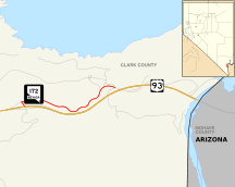
State Route 172 (SR 172) is a state highway in Clark County, Nevada. The route provides access to Hoover Dam from U.S. Route 93 (US 93).
Route description
_at_U.S._Route_93_(Hoover_Dam_Bypass)_in_Clark_County%2C_Nevada.jpg)
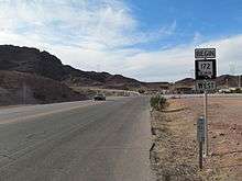
State Route 172 begins at an interchange with US 93 approximately 5 miles (8.0 km) northeast of downtown Boulder City. From there, the route travels eastward, following the curvy mountainside headed towards Hoover Dam. The SR 172 designation ends 1.61 miles (2.59 km) west of the Arizona state line at the Hoover Dam security checkpoint. While the state highway ends at this point, the Hoover Dam Access Road continues eastward, passing the Mike O'Callaghan – Pat Tillman Memorial Bridge Plaza and ending at the Hoover Dam visitor center.[1]
History
SR 172 was originally part of US 93.[1] US 93 was rerouted onto the Hoover Dam Bypass when construction was completed in October 2010, and the new state highway was designated over the old route.
Major intersections
The entire route is in Clark County.
| Location | mi[1] | km | Destinations | Notes | |
|---|---|---|---|---|---|
| | 0.00 | 0.00 | Interchange | ||
| | 1.61 | 2.59 | Hoover Dam Access Road – Hoover Dam | Continuation beyond terminus | |
| 1.000 mi = 1.609 km; 1.000 km = 0.621 mi | |||||
References
- 1 2 3 4 State Maintained Highways of Nevada: Descriptions and Maps (PDF). Nevada Department of Transportation. January 2011. Retrieved 23 January 2011.