Nevada State Route 170
| ||||
|---|---|---|---|---|
| Bunkerville Road | ||||
|
Nevada State Route 170, highlighted in red | ||||
| Route information | ||||
| Maintained by NDOT | ||||
| Length: | 12.268 mi[1] (19.743 km) | |||
| Existed: | 1976 – present | |||
| Major junctions | ||||
| West end: |
| |||
| East end: | Mesquite Boulevard in Mesquite | |||
| Location | ||||
| Counties: | Clark | |||
| Highway system | ||||
| ||||

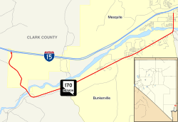
State Route 170 (SR 170) is the designation given to Riverside Road from Interstate 15 (I-15) Exit 112 to former SR 144 in downtown Mesquite. All of SR 170 was, at one time, U.S. Route 91, which used to stretch from Sweetgrass, Montana to Long Beach, California. It is also called Bunkerville Road.
Major intersections
_in_Clark_County%2C_Nevada.jpg)
View east from the west end of SR 170
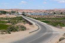
SR 170 crossing the Virgin River from Mesquite
The entire route is in Clark County.
| Location | mi | km | Destinations | Notes | |
|---|---|---|---|---|---|
| | 0.000 | 0.000 | I-15 exit 112. | ||
| Mesquite | 12.268 | 19.743 | Mesquite Boulevard | Former SR 144 | |
| 1.000 mi = 1.609 km; 1.000 km = 0.621 mi | |||||
See also
 Nevada portal
 U.S. Roads portal
References
- ↑ "Nevada's State Maintained Highways: Descriptions, Index and Maps" (PDF). Nevada Department of Transportation. 2013. Retrieved 2013-12-26.
External links
| Wikimedia Commons has media related to Nevada State Route 170. |
This article is issued from Wikipedia - version of the 11/11/2016. The text is available under the Creative Commons Attribution/Share Alike but additional terms may apply for the media files.