Nevada State Route 157
| ||||
|---|---|---|---|---|
| Kyle Canyon Road | ||||
|
Nevada State Route 157, highlighted in red | ||||
| Route information | ||||
| Maintained by NDOT | ||||
| Length: | 21.428 mi[1] (34.485 km) | |||
| Existed: | 1976 – present | |||
| Major junctions | ||||
| West end: | Mount Charleston | |||
| East end: |
| |||
| Location | ||||
| Counties: | Clark | |||
| Highway system | ||||
| ||||

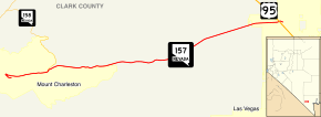
State Route 157 (SR 157), also known as Kyle Canyon Road, is a U.S. state highway in Clark County, Nevada. The highway connects the Las Vegas area to the recreational areas of Mount Charleston in the Spring Mountains.
Located in the Humboldt-Toiyabe National Forest, a portion of SR 157 has been designated a Nevada Scenic Byway. The route was originally State Route 39, and has origins dating back to the 1930s.
Route description
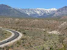
_near_Las_Vegas%2C_Nevada.jpg)

State Route 157 is located 15 miles (24 km) north of Las Vegas. The route starts at its junction with U.S. Route 95 (US 95) where it heads west rapidly gaining elevation. Within a span of 20 miles (32 km) an elevation of 3000 feet (900 m) is gained with noticeable difference: temperatures drop, trees and shrubs become greener and more numerous and there is lasting snow cover during winter months. Part of the route is designated as a Nevada Scenic Byway. The highway's western terminus is past the village of Mount Charleston where it winds up the side of the mountain for a short distance before U-turning back.
History
Kyle Canyon Road has existed since at least 1933, having been established as a county road connecting Charleston Peak (in what was then Dixie National Forest) to State Route 5 (now US 95) at Tule to the east.[2] By 1935, the entire 21 miles (34 km) of the highway had been paved and designated as State Route 39 by the state.[3]
SR 39 appears to have remained unchanged for several years after being included in the state highway system. Its first major change occurred on July 1, 1976, when the route was renumbered to State Route 157 in the mass renumbering of Nevada's state highways.[4] This change was first reflected on official state maps in 1978.[5]
In July 1998, the Nevada Department of Transportation designated SR 157 as a Nevada Scenic Byway. The scenic route encompasses the westernmost 13 miles (21 km) of the highway within the national forest area.[6]
Major intersections
The entire route is in Clark County.
| Location | mi[1][7] | km | Destinations | Notes | |
|---|---|---|---|---|---|
| Mount Charleston | 0.00 | 0.00 | Charleston Park | Dead end | |
| Las Vegas | 21.44 | 34.50 | |||
| 1.000 mi = 1.609 km; 1.000 km = 0.621 mi | |||||
See also
 Nevada portal
 U.S. Roads portal
References
| Wikimedia Commons has media related to Nevada State Route 157. |
- 1 2 "State Maintained Highways of Nevada: Descriptions and Maps - Quarter 2 Update". Nevada Department of Transportation. July 2011. Retrieved 4 Oct 2011.
- ↑ Official Road Map of Nevada (Map). Nevada State Highway Department. 1933. Retrieved 2009-08-11.
- ↑ Official Road Map of Nevada (Map). Nevada State Highway Department. 1935. Retrieved 2009-08-11.
- ↑ Nevada State Maintained Highways: Descriptions, Index and Maps. Nevada Department of Transportation. January 2001. p. 98.
- ↑ Official Highway Map of Nevada (Map) (1978-79 ed.). Nevada State Highway Department. 1978. § F5. Retrieved 2009-08-11.
- ↑ Nevada Department of Transportation. "Nevada's Scenic Byways". Retrieved 2009-08-09.
- ↑ Maps of Milepost Location on Nevada's Federal and State Highway System by County (PDF). Nevada Department of Transportation. May 2008. Archived (PDF) from the original on August 10, 2009. Retrieved 2009-08-10.