Neuwied (district)
| Neuwied | ||
|---|---|---|
| District | ||
| ||
 | ||
| Country |
| |
| State | Rhineland-Palatinate | |
| Capital | Neuwied | |
| Area | ||
| • Total | 626.80 km2 (242.01 sq mi) | |
| Population (31 December 2015)[1] | ||
| • Total | 180,655 | |
| • Density | 290/km2 (750/sq mi) | |
| Time zone | CET (UTC+1) | |
| • Summer (DST) | CEST (UTC+2) | |
| Vehicle registration | NR | |
| Website | kreis-neuwied.de | |
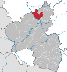
Neuwied is a district (Kreis) in the north of Rhineland-Palatinate, Germany. Neighboring districts are (from north clockwise) Rhein-Sieg, Altenkirchen, Westerwaldkreis, Mayen-Koblenz, Ahrweiler.
History
The district was created in 1816 when the area became part of the Prussian Rhine province. In 1822 the district Linz was merged into the district.
The district has a partnership with the Polish county Namysłów in Opole Voivodeship; first contacts date to 1998 and the partnership became official in 2000.
Geography
The districts landscape covers the Westerwald mountains, east of the Rhine river valley. The Rhine forms the western boundary of the district.
Coat of arms
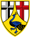 |
The crosses in the top represent the two clerical states which owned part of the district - the black cross of Cologne in the left, the red cross of Trier in the right. The peacock in the bottom is taken from the coat of arms of the Counts of Wied. |
Towns and municipalities
Verband-free town: Neuwied
| Verbandsgemeinden | ||
|---|---|---|
|
|
|
| 1seat of the Verbandsgemeinde; 2town | ||
References
- ↑ "Gemeinden in Deutschland mit Bevölkerung am 31. Dezember 2015" (PDF). Statistisches Bundesamt (in German). 2016.
External links
- Official website (German)
| Wikimedia Commons has media related to Landkreis Neuwied. |
Coordinates: 50°30′N 7°30′E / 50.5°N 7.5°E
This article is issued from Wikipedia - version of the 11/8/2016. The text is available under the Creative Commons Attribution/Share Alike but additional terms may apply for the media files.