Nervión
| Nervión | |
| Basque: Nerbioi | |
| River | |
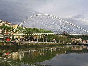 River Nervion with Zubizuri footbridge. | |
| Country | |
|---|---|
| Region | Basque Country |
| Districts | Álava, Biscay |
| Tributaries | |
| - left | Kadagua, Galindo |
| - right | Altube, Ibaizabal, Asua |
| City | Bilbao |
| Source | Delika canyon |
| - location | Sierra Salbada, Álava, Spain |
| - elevation | 1,000 m (3,281 ft) |
| Mouth | Estuary of Bilbao |
| - location | Bay of Biscay between Portugalete and Getxo, Spain |
| - elevation | 0 m (0 ft) |
| Length | 72 km (45 mi) |
| Basin | 1,900 km2 (734 sq mi) |
| Discharge | for Portugalete and Getxo |
| - average | 9.6 m3/s (339 cu ft/s) |
| Wikimedia Commons: Nervión | |
| Website: Greater Bilbao Water Authority | |
The Nervión river (Basque: Nerbioi) runs through the city of Bilbao, Spain into the Cantabrian Sea (Bay of Biscay). Its lowermost course, downstream of its confluence with the Ibaizabal River, is known as the Estuary of Bilbao.
Geography
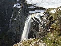
The river is 72 kilometres (45 mi) long from its source at the Burgos and Alava provincial limits to the sea and runs in South to North direction. Soon after its source, the river forms a spectacular 300-metre (980 ft) waterfall in the Delika canyon (Alava) and then enters the Biscay province through the town of Orduña. It goes into Alava again through the towns of Amurrio and Llodio. Then the river runs again into the Biscay province until the Cantabrian sea, entering the Bilbao metropolitan area at Ugao-Miraballes. The tidal influence reaches 15 kilometres (9 mi) inland from the sea, at Bilbao's old town.
The main tributaries are:
Ibaizabal is considered by some to be an equally important river, so the whole system is often called Nervión-Ibaizabal and the final tract just "Estuary of Bilbao". The basin area is 1,900 square kilometres (730 sq mi).
Controversy
Despite its current success in Spanish use, the traditional name of the stretch between the estuary and Basauri, where both Ibaizabal and Nervión merge, is Ibaizabal (meaning 'wide river' in Basque), according to historical evidence tracing back to the 11th century and up to the 20th. The literature writer native of Bilbao Miguel de Unamuno (1864–1936) as well as mayor of Bilbao Javier Ybarra (1913–1977) refer to it as Ibaizabal. Geological and hydrological data also seem to support that assumption.[1]
History and economy
From ancient times, the Orduña pass that links Spain's inner plateau with the Nervión valley has had a great economic impact. During the Middle Age it served as a natural border between the Biscay lordship and Castile counties, entry taxes were collected there. Through the centuries, the Nervión valley was a vital communication corridor for Biscay, and the main railroad from Bilbao to the rest of Spain was constructed following the river in 1870.
At the same time, Bilbao developed a great commercial activity, with its seaport being the most important in the north coast of Spain. The port's activity relied totally in the navigability of the river in its final 15 kilometres (9 mi). So engineer Evaristo Churruca developed an enormous project that would solve the traditional navigation problems of the river. The estuary divided the population of the Greater Bilbao, the Left Bank was occupied by factories (steel, metalwork, shipbuilding) and their workers, the Right Bank was a residential area for the factory owners.
Now the Nervión river has lost economic importance, the navigable part of the river is being abandoned in favour of the external port, to allow urban development to take place in the banks of the river after the dismantlement of the industry. The quality of the water has improved through refuse water cleaning and the disappearance of the most polluting industries.
Environment
After a century of intense industrial activity the river, especially the final 25 kilometres (16 mi), was ecologically dead with oxygen levels 20 percent below the norm. This made the Nervión one of the most polluted rivers in the world. In 1990 the local authorities launched a plan to overcome this situation, resulting in a constant improvement of the environmental status that after 15 years has transformed the Nervión in a clean river, full of aquatic life.
See also
References
- ↑ "Bilboko itsasadarra ibai zabala da". Santurtziko Udal Euskaltegia. Retrieved 2008-05-16. Article in Basque
External links
Coordinates: 43°19′31.82″N 3°01′09.74″W / 43.3255056°N 3.0193722°W