Neruda quadrangle
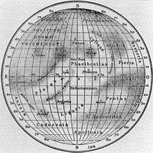
1934 map showing the Solitudo Persephones albedo feature
The Neruda quadrangle (H-13) is one of fifteen quadrangles on Mercury. It runs from 180 to 270° longitude and -20 to -70° latitude. Named after the Neruda crater, it was mapped in detail for the first time after MESSENGER entered orbit around Mercury in 2011. It had not been mapped prior to that point because it was one of the six quadrangles that was not illuminated (with the exception of a narrow strip along the eastern border with the Michelangelo quadrangle) when Mariner 10 made its flybys in 1974 and 1975. These six quadrangles continued to be known by their albedo feature names, with this one known as the Solitudo Persephones quadrangle.[1][2]
| Quadrangles on Mercury | |||||||
|---|---|---|---|---|---|---|---|
| H-1 Borealis (features) | |||||||
| H-5 Hokusai (features) |
H-4 Raditladi (features) |
H-3 Shakespeare (features) |
H-2 Victoria (features) | ||||
| H-10 Derain (features) |
H-9 Eminescu (features) |
H-8 Tolstoj (features) |
H-7 Beethoven (features) |
H-6 Kuiper (features) | |||
| H-14 Debussy (features) |
H-13 Neruda (features) |
H-12 Michelangelo (features) |
H-11 Discovery (features) | ||||
| H-15 Bach (features) | |||||||
References
- ↑ "1:5 Million-Scale Maps of Mercury". Gazetteer of Planetary Nomenclature (USGS/IAU/NASA). Retrieved 2013-09-19.
- ↑ "SP-423 Atlas of Mercury". NASA. p. 21. Retrieved 2013-09-19.
This article is issued from Wikipedia - version of the 9/13/2015. The text is available under the Creative Commons Attribution/Share Alike but additional terms may apply for the media files.