Neponsit, Queens
| Neponsit | |
|---|---|
| Neighborhood of Queens | |
|
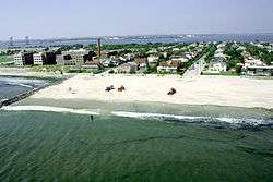
Aerial view of Neponsit near Jacob Riis Park | |
| Country | United States |
| State | New York |
| County | Queens |
| Named for | "the place between waters" |
| Population | |
| • Estimate (2007) | 2,000 |
| ZIP code | 11694 |
| Area code(s) | 718, 347, 917 |
Neponsit is a small affluent neighborhood located on the western half of the Rockaway Peninsula, the southernmost area of the New York City borough of Queens. The area starts at Beach 142nd Street and ends at Beach 149th Street.[1] It borders the neighborhood of Belle Harbor to the east and Jacob Riis Park on the west. Jamaica Bay and the Atlantic Ocean are the northern and southern borders. The neighborhood is part of Queens Community Board 14. As of January 1, 2007, the neighborhood's population reached just over 2,000, making it one of the smallest communities on the peninsula, as well in the entire borough of Queens.[2]
Neponsit's zoning is residential, R-1 and R-2, a rarity in New York City.[3] This category of zoning prohibits any commercial structures and only allows single family homes to be built. Due to this, and its secluded beach location, some homes are mansion-like, and the average market price for properties has exceeded $5.1 million, according to Zillow.
History
Neponsit is a Native American name meaning "the place between waters", the waters of the Atlantic Ocean and of Jamaica Bay or Rockaway Inlet.[4]
The present community's character has persisted since it was established. In January 1910, the Neponsit Realty Company purchased the land for the development of an exclusive community. It forbade the construction of any homes that were inexpensive, and the homes were built in order to withstand the beach weather and geography of the narrow peninsula. The entrance to the area was originally marked by a massive ornamental gateway. More recently, a stretch of tree-dotted islands, called "the malls", situated along Rockaway Beach Boulevard, was a distinguishing feature. It extended through Belle Harbor. By the 1930s, high quality homes were dominant in Neponsit.
The first transatlantic flight departed from Neponsit. On May 8, 1919, four United States Navy-Curtis model seaplanes took off from what is now Beach Channel Drive in Neponsit to Newfoundland, Canada, the Azores Islands, and Lisbon, Portugal. Finally on May 31, 1919, only one plane, piloted by Lt. Commander Albert C. Read, arrived in Plymouth, England.[5]
The television show, Rescue Me (FX Network) has regularly filmed in Neponsit using residences to portray the fictional homes of some of the characters, although the article points out that the "story never tells you how a firefighter can afford ... [a] Neponsit home".[6]
See also
References
| Wikimedia Commons has media related to Neponsit, Queens. |
- ↑ Neponsit Home Page, The Wave, Rockaway's Local Newspaper, accessed June 10, 2007
- ↑ Briano, Nicholas (March 21, 2008). "Rockaway Population Popping At Record Pace". The Wave. Retrieved October 18, 2008.
- ↑ "NYC Department of City Planning Zoning Maps - Historical" (PDF). Retrieved 4 December 2012.
- ↑ Seyfried, Vincent; Asadorian, William (1999). Old Rockaway, New York, in Early Photographs. Mineola, NY: Dover Publications. p. 93. ISBN 0-486-40668-7. Retrieved August 7, 2010.
- ↑ "Neponsit Malls". New York City Department of Parks & Recreation. Retrieved August 7, 2010.
- ↑ Schwach, Howard (July 30, 2004). "'Rescue Me' Highlights Rockaway In Premier Episode". The Wave. Retrieved October 17, 2008.
http://www.zillow.com/homedetails/137-Beach-146th-St-Neponsit-NY-11694/32228944_zpid/

Coordinates: 40°34′17″N 73°51′41″W / 40.57139°N 73.86139°W