Neil Island
| Nickname: James Neill Island | |
|---|---|
 Neill Island  Neill Island | |
| Geography | |
| Location | Bay of Bengal |
| Coordinates | 11°50′N 93°02′E / 11.83°N 93.04°ECoordinates: 11°50′N 93°02′E / 11.83°N 93.04°E |
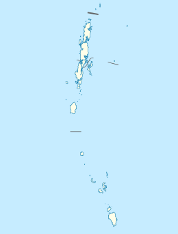
| Archipelago | Andaman Islands |
| Adjacent bodies of water | Indian Ocean |
| Total islands | 1 |
| Major islands |
|
| Area | 13.7 km2 (5.3 sq mi)[1] |
| Length | 3.7 km (2.3 mi) |
| Width | 6.3 km (3.91 mi) |
| Coastline | 19.4 km (12.05 mi) |
| Highest elevation | 101 m (331 ft)[2] |
| Highest point | Nipple Hill |
| Administration | |
| District | South Andaman |
| Island group | Andaman Islands |
| Island sub-group | Ritchie's Archipelago |
| Tehsil | Port Blair Tehsil |
Largest settlement |
Neill Kendra pop. 1000 |
| Demographics | |
| Demonym | Hindi |
| Population | 3040 (2011) |
| Pop. density | 222.00 /km2 (574.98 /sq mi) |
| Ethnic groups | Hindu, Andamanese |
| Additional information | |
| Time zone | |
| PIN | 744104[3] |
| Telephone code | 031927 [4] |
| Official website |
www |
| ISO Code | IN-AN-00[5] |
| Literacy | 84.4% |
| Avg. summer temperature | 30.2 °C (86.4 °F) |
| Avg. winter temperature | 23.0 °C (73.4 °F) |
| Sex ratio | 1.2♂/♀ |
| unit_pref | Metric |
| Census Code | 35.639.0004 |
| Official Languages | Hindi, English |
Neill Island is an island of the Andaman Islands, located in Ritchie's Archipelago. It belongs to the South Andaman administrative district, part of the Indian union territory of Andaman and Nicobar Islands.[6] the island is lying 36 km (22 mi) northeast from Port Blair.
Etymology
Neill is named after British Brigadier general James Neill, who had sternly dealt with the freedom fighters during the suppression of the 1857 Mutiny.
History
Neill Island was uninhabited until the arrival of settlers in the late 1960s. Like Havelock, the vast majority of settlers at Neill were refugees from erstwhile Bangladesh, following the exodus of Hindu Bangladeshi's prior to that country's war of independence in 1971.
Geography
The island belongs to the Ritchie's Archipelago and is located between Havelock Island and Rose Island. It is a comparatively flat island, and much of the landmass was deemed suitable for paddy cultivation. Unfortunately, as a result of this, very little forest cover remains at Neil, and almost all of it is concentrated in the reserve forest on Neil's north-western side. Neill island tends to remain a degree or two warmer than Havelock as a result of the lack of forest cover. The island is not without charm however, but it is a different, pastoral sort of charm that the island offers.
Administration
Politically, Neill Island is part of Neill Kendra panchayat, of Port Blair Taluk.[7]
Demographics
The population of 3040 lives in five villages, which are numbered 1 through 5 (with population at 2011 census in parentheses):[8]
- Sitapur (274)
- Bharatpur (629)
- Neill Kendra (1000)
- Lakshmanpur (382)
- Ram Nagar (755)
Transportation
There is a lone jetty at Neill Kendra, which serves as the only entry–exit point of the island.[9] There are regular Government ferry from Port Blair to Neill Island. There are private cruise ships such as Makruzz and Coastal Cruise.[10]
Economy
Agriculture is the primary occupation of the villagers, and the island supplies vegetables to the rest of Andaman.
Tourism
Despite its minuscule tourist infrastructure, an increasing number of tourists have chosen to stay at Neill Island instead of neighboring Havelock Island. There are a handful of restaurants and basic beach hotels that cater to international and domestic tourists. There are very few options to stay in Neill Island. Below are the currently known hotels
- Silver Sand Beach Resort[11]
- Hotel Kingfisher[12]
- Sea Shell Resort[13]
- Pearl Park Resort[14]
- Tango Resort[15][16]
All hotels and associated details for Neill Island can be found at.[17] Internet connectivity is extremely poor in this island. Travelers are suggested to complete any online related tasks in Port Blair or Havelock Island before arriving in this island. Sitapur is considered to be the best beach on the island.[18] The Natural Bridge:[19]
Image gallery
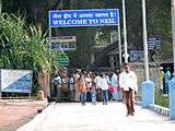 Entry to Neill Island from Bharatpur Jetty.
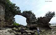 Hawrah Natural Bridge, Neill Island.
 Coral Reef
 Star Fish at Neill Island
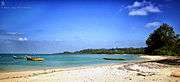 Neill Island
 Bharathpur Jetty
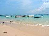 Bharatpur Beach
 A Farmer with coconut cutting weapon
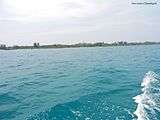 Bharatpur beach and Havelock Island view
 Hawrah Natural Bridge site
 Bharatpur beach and Havelock Island view
 Landscape
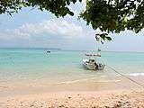 Bharatpur beach
 Ritchie's Archipelago within the Andaman Islands
 Neill Island within Ritchie's Archipelago
References
- ↑ "Islandwise Area and Population - 2011 Census" (PDF). Government of Andaman.
- ↑ "Sailing Directions (enroute) | India and the Bay of Bengal" (PDF) (173). National Geospatial-intelligence Agency, United States Government. 2014. Retrieved 2016-09-23.
- ↑ "A&N Islands - Pincodes". 22 September 2016. Retrieved 22 September 2016.
- ↑ "STD Codes of Andaman and Nicobar". allcodesindia.in. Retrieved 2016-09-23.
- ↑ Registration Plate Numbers added to ISO Code
- ↑ "Village Code Directory: Andaman & Nicobar Islands" (PDF). Census of India. Retrieved 2011-01-16.
- ↑ "DEMOGRAPHIC – A&N ISLANDS" (PDF). andssw1.and.nic.in. Retrieved 2016-09-23.
- ↑ "Census of India: Sub-District Details".
- ↑
- ↑ Experience Andaman. "Ferry in Andaman Service, Timings and Tickets - Experience Andamans".
- ↑ "Silver Sand Neill - Just another WordPress site".
- ↑ Hotel King Fisher Nil Island. "Hotels in Neill Island, Neill Island Hotels, Hotels in Neill.".
- ↑ Shiva. "Resort in Andaman Nicobar Island, Beach Hotels in Portblair, Havelock,Neill.".
- ↑ Andaman Pearl Park Beach Resort. "Welcome to Andaman Pearl Park, Neill Island, Andaman & Nicobar Islands".
- ↑ Tango Beach Andaman. "Tango beach resort - best seaside resort in andaman - best hotel in andaman".
- ↑ resort
- ↑ "Neill".
- ↑ beaches
- ↑ attractions
| Wikimedia Commons has media related to Neill Island. |
| Wikivoyage has a travel guide for Neill Island. |