Nei Lingding Island
| Nei Lingding Island | |||||||
|
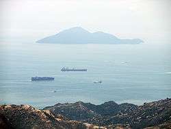
Nei Lingding Island from Castle Peak, Hong Kong | |||||||
| Traditional Chinese | 內伶仃㠀 | ||||||
|---|---|---|---|---|---|---|---|
| Simplified Chinese | 内伶仃岛 | ||||||
| Postal | Lintin Island | ||||||
| Literal meaning | Inner Lonely Island | ||||||
| |||||||
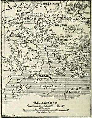
Nei or Inner Lingding Island, formerly romanized as Lintin or Lin Tin Island, is an island in the Pearl River estuary in the southeastern Chinese province of Guangdong. Although it is located closer to the eastern (Hong Kong and Shenzhen) shore of the estuary, it was until 2009 administratively part of the prefecture-level city of Zhuhai, whose main administrative center is located on the west shore of the river. The jurisdiction of Nei Lingding Island was handed over to Shenzhen in 2009.[1]
History
In May 1513, the Portuguese explorer Jorge Álvares arrived at an island near the coast of China they called "Tamão".[2] This was the first contact of Europeans with China via the sea route around the Cape of Good Hope.[5] Tamão was fortified by Simão de Andrade and assaulted by the Chinese during the expulsion of the Portuguese in the 1520s.[6] Nei Lingding Island, the main island standing in the mouth of the Pearl River, 6 km off the mainland, is identified by J. M. Braga to be the Tamão of the Portuguese sources, and is widely followed by Western scholarship; however, recent Chinese scholarship finds this identification to be insufficiently proven, and suggests a number of other potential islands including the nearby but far larger Lantau Island.[7]
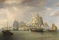
As of 1814[8] Nei Lingding (then romanized as "Lintin") was called the "outer anchorage" for European ships traveling to Guangzhou ("Canton"). They would have to stop at the island, have their cargo inspected and measured by the Chinese customs officials stationed at the island, and pay customs duties. In 1821, when the Chinese government prohibited importation of opium into the country's ports, Lintin became a base for drug smugglers; old boats hulks, anchored near the island, served as warehouses and depots where imported opium would be reloaded to smaller boats to be smuggled into Guangzhou and other ports. Edmund Roberts visited the island in 1832, and noted that there were "seven to eight ships" smuggling opium, including American boats.[8] From the 1830s until the cession of Hong Kong in the 1840s, Lintin Island was the main base for British merchants in the Pearl River Delta area.[9][10] The island was a stopping point during monsoon season for ship repair. Ships would stay on the island upwards of six months.[8]
Demographics
As of 1814, the population was approximated at less than 60. As of 1821, just under 2,000. When Edmund Roberts visited in 1832, he noted a population of approximately 5,000.[8]
Nature reserve
Since 1984,[11] a part of the island forms the "Neilingding Island and Futian (福田) Nature Reserve". The reserve covers 7.8 square kilometres (3.0 sq mi), including 4.5 square kilometres (1.7 sq mi) of land area and 3 square kilometres (1.2 sq mi) of mangrove forest, and was created to protect some 300 rhesus macaques and other animals, such as pangolins and pythons.[12]
See also
- Wai Lingding Island ('Outer Lingding Island') lies some 40 kilometres (25 mi) to the southeast, in the Wanshan Archipelago.
References
- ↑ (Chinese) 内伶仃岛归属深圳市管辖, sznews.com, 2009-09-26
- ↑ Braga,[3] cited in Cultural Heritage Assessment[4]
- ↑ Braga, J. M. (1956), China Landfall 1513, Jorge Alvares Voyage to China, Macau: Imprensa Nacional, OCLC 10673337.
- ↑ Cultural Heritage Assessment
- ↑ Construction of Lung Kwu Chau Jetty - Cultural Heritage Impact Assessment
- ↑ Cortesao (1944), p. xxx.
- ↑ Jin, Guoping (2000). Xili dongjian : Zhong-Pu zaoqi jiechu zhuixi 西力東漸 : 中葡早期接觸追昔 (in Chinese). Macau: Macao Foundation. pp. 21–42. ISBN 9993710075.
- 1 2 3 4 Roberts, Edmund (1837). Embassy to the Eastern Courts of Cochin-China, Siam, and Muscat. New York: Harper & Brothers. p. 69.
- ↑ "Shameen: A Colonial Heritage", By Dr Howard M. Scott
- ↑ China in Maps - A Library Special Collection
- ↑ Neilingding Island-Futian National Nature Reserve of Guangdong
- ↑ NEILINGDING ISLAND AND FUTIAN NATURE RESERVE
| Wikimedia Commons has media related to Nei Lingding Island. |
Coordinates: 22°24′46″N 113°48′13″E / 22.41278°N 113.80361°E