Neel, Alabama
| Neel, Alabama | |
|---|---|
| Unincorporated community | |
|
Neel, Alabama, seen from west of the five-way stop. | |
 Neel, Alabama Location in Alabama. | |
| Coordinates: 34°27′56″N 87°03′40″W / 34.46556°N 87.06111°W | |
| Country | United States |
| State | Alabama |
| County | Morgan |
| Elevation | 620 ft (189 m) |
| Time zone | Central (CST) (UTC-6) |
| • Summer (DST) | CDT (UTC-5) |
| ZIP code | 35640, 35619 |
| Area code(s) | 256 |
| GNIS feature ID | 160222[1] |
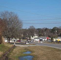
Neel (/ˈniːl/ NEEL ) is an unincorporated community in western Morgan County, Alabama, United States. It is located south of Decatur and west of Hartselle at the 5-way stop intersection of Ironman Road, Danville Road, and Neel School Road. For statistical purposes, Neel is included within the Decatur Metropolitan Area which is, in turn, part of the Huntsville-Decatur Combined Statistical Area. A post office operated under the name Neel from 1890 to 1906.[2]
References
- ↑ "Neel". Geographic Names Information System. United States Geological Survey.
- ↑ "Morgan County". Jim Forte Postal History. Retrieved 29 December 2014.
Municipalities and communities of Morgan County, Alabama, United States | ||
|---|---|---|
| Cities | 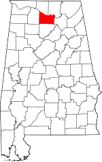 | |
| Towns | ||
| Unincorporated communities | ||
| Ghost town | ||
| Footnotes | ‡This populated place also has portions in an adjacent county or counties | |
This article is issued from Wikipedia - version of the 12/30/2014. The text is available under the Creative Commons Attribution/Share Alike but additional terms may apply for the media files.