Navy Island
 | |
| Geography | |
|---|---|
| Location | Niagara River |
| Area | 1.2 km2 (0.46 sq mi) |
| Administration | |
| Province | Ontario |
| Additional information | |
| Designated | 1921 |
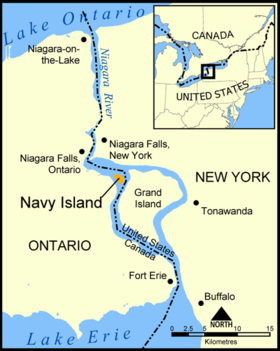
Navy Island is a small, uninhabited island in the Niagara River in the province of Ontario, managed by Parks Canada as a National Historic Site of Canada. It is located about 4.5 km (2.8 mi) upstream from Horseshoe Falls, and has an area of roughly 1.2 km2 (0.46 sq mi). It was designated a national historic site in 1921 in recognition of its role in shipbuilding and the location of the short-lived Republic of Canada.[1][2] The site is closed to the public, has no visitor facilities, and has not allowed camping since the expiration of a lease with the Niagara Parks Commission.[3]
History
Navy Island was settled by the Lamoka people in approximately 2000 BC and Meadowood culture peoples in 1000 BC.[4]
During the French colonization of New France, Navy Island was known as Île de la Marina. Here the French built four ships that they used to service the Great Lakes. When New France was ceded to the British in 1763, they set up a shipyard here. In the War of 1812, a detachment was stationed on the island.
In 1837, William Lyon Mackenzie and about 200 of his supporters captured the island and proclaimed the Republic of Canada there. Initially Mackenzie started with twenty-five men, but the population eventually swelled to over six hundred men.[5] On January 11, 1838, the rebels were forced from the island and retreated across the river into the United States.
In 1875, the Queens Hotel was established as a popular summer resort on the island's south side. It was destroyed by fire in 1910.
Farms and orchards were located on the northeast, south, central, northwest and southwest ends of the island. Since abandoned, most of the farmed lands have been re-forested. There are some reminders of habitation on the south side. A pier still exists for boaters to the island. Permit is needed for camping.
Navy Island was proposed to be the new World Peace Capital and headquarters of the United Nations by an international committee in 1945 and 1946. The island was considered to be an ideal location as it lay on the boundary between two peaceful countries. An artist's rendering of the World Peace Capital showed the property with bridges spanning both countries (at Grand Island in the US and the Canadian mainland on the other side).[6][7] It was proposed that Navy Island would be ceded to the United Nations as long as the headquarters remained, and to revert to the Canadian government should the U.N. move. The proposal was ultimately turned down in favor of the current U.N. headquarters in New York City.
References
- ↑ Navy Island, Directory of Designations of National Historic Significance of Canada
- ↑ Navy Island. Canadian Register of Historic Places.
- ↑ "Natural Wonders and Cultural Treasures — Navy Island". Parks Canada. Retrieved October 31, 2016.
- ↑ "Navy Island - Oasis of Niagara Falls Wildlife & Mature Forest, Canada". InfoNiagara.com. Niagara Central Reservations. Retrieved October 31, 2016.
- ↑ Peppiatt, Liam. "Chapter 78: Mackenzie as an Exile". Robertson's Landmarks of Toronto Revisited.
- ↑ As seen in Record ID: 95751, "Proposed United Nations Headquarters on Navy Island Niagara Falls, ca 1945", Niagara Falls Public Library Local History Collection, Niagara Falls Public Library, Niagara Falls, Ontario
- ↑ International Committee to promote Navy Island as permanent headquarters for the United Nations (1945), Proposed United Nations Headquarters, Navy Island at Niagara Falls on the international boundary between Canada and the United States, Buffalo, N.Y.: Baker, Jones, Hausauer, Inc., OCLC 19806713
External links
| Provinces | |
|---|---|
| Territories | |
| Other countries | |
| |
Coordinates: 43°03′20″N 79°00′35″W / 43.055437°N 79.009595°W