National Register of Historic Places listings in San Benito County, California
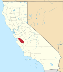
Location of San Benito County in California
This is a list of the National Register of Historic Places listings in San Benito County, California.
This is intended to be a complete list of the properties and districts on the National Register of Historic Places in San Benito County, California, United States. Latitude and longitude coordinates are provided for many National Register properties and districts; these locations may be seen together in an online map.[1]
There are 15 properties and districts listed on the National Register in the county, including 3 National Historic Landmarks.
- This National Park Service list is complete through NPS recent listings posted December 16, 2016.[2]
Current listings
| [3] | Name on the Register[4] | Image | Date listed[5] | Location | City or town | Description |
|---|---|---|---|---|---|---|
| 1 | Anza House | .jpg) |
(#70000140) |
3rd and Franklin Sts. 36°50′37″N 121°32′08″W / 36.843622°N 121.535583°W |
San Juan Bautista | Also known as Juan de Anza House |
| 2 | Bear Valley School | 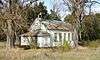 |
(#14000267) |
East side of Highway 25, 1 mile (1.6 km) north of junction with Highway 146 36°32′03″N 121°08′49″W / 36.534068°N 121.147075°W |
Paicines | |
| 3 | Jose Castro House | 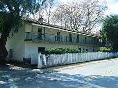 |
(#70000141) |
S side of the Plaza 36°50′41″N 121°32′05″W / 36.844722°N 121.534722°W |
San Juan Bautista | |
| 4 | Chalone Creek Archeological Sites | Upload image | (#78000365) |
Address Restricted |
Soledad | |
| 5 | Downtown Hollister Historic District | 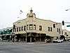 |
(#92000974) |
Roughly bounded by Fourth, East, South and Monterey Sts. 36°51′00″N 121°24′03″W / 36.85°N 121.400833°W |
Hollister | |
| 6 | Joel and Rena Hawkins House | 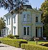 |
(#93000669) |
801 South St. 36°50′54″N 121°24′32″W / 36.848333°N 121.408889°W |
Hollister | |
| 7 | Hollister Carnegie Library | 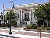 |
(#92000269) |
375 Fifth St. 36°51′04″N 121°24′08″W / 36.851111°N 121.402222°W |
Hollister | |
| 8 | Harrison Lyons Homestead Historic District | Upload image | (#16000521) |
Address Restricted |
Paicines | |
| 9 | Marentis House | 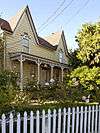 |
(#84000951) |
45 Monterey St. 36°50′47″N 121°32′29″W / 36.846389°N 121.541389°W |
San Juan Bautista | |
| 10 | Roy D. McCallum House | 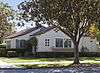 |
(#97001445) |
1401 San Benito St. 36°50′25″N 121°24′03″W / 36.840278°N 121.400833°W |
Hollister | |
| 11 | Monterey Street Historic District | 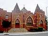 |
(#92001740) |
Monterey St. and intersecting streets between 5th and B Sts. 36°50′50″N 121°24′12″W / 36.847222°N 121.403333°W |
Hollister | |
| 12 | Rozas House | 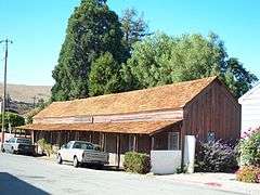 |
(#82002243) |
31 Polk St. 36°50′42″N 121°32′17″W / 36.844978°N 121.538097°W |
San Juan Bautista | |
| 13 | San Juan Bautista Plaza Historic District | 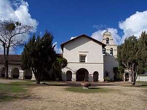 |
(#69000038) |
Buildings surrounding plaza at Washington, Mariposa, and 2nd Sts. 36°50′44″N 121°32′04″W / 36.845556°N 121.534444°W |
San Juan Bautista | |
| 14 | San Juan Bautista Third Street Historic District | 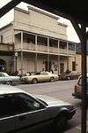 |
(#08001277) |
3rd St. between 406 3rd St. and Franklin St. 36°50′40″N 121°32′12″W / 36.844556°N 121.536694°W |
San Juan Bautista | |
| 15 | Benjamin Wilcox House |  |
(#82002244) |
315 The Alameda 36°50′25″N 121°31′57″W / 36.840278°N 121.5325°W |
San Juan Bautista |
See also
| Wikimedia Commons has media related to National Register of Historic Places in San Benito County, California. |
- List of National Historic Landmarks in California
- National Register of Historic Places listings in California
- California Historical Landmarks in San Benito County, California
References
- ↑ The latitude and longitude information provided in this table was derived originally from the National Register Information System, which has been found to be fairly accurate for about 99% of listings. For about 1% of NRIS original coordinates, experience has shown that one or both coordinates are typos or otherwise extremely far off; some corrections may have been made. A more subtle problem causes many locations to be off by up to 150 yards, depending on location in the country: most NRIS coordinates were derived from tracing out latitude and longitudes off of USGS topographical quadrant maps created under the North American Datum of 1927, which differs from the current, highly accurate WGS84 GPS system used by most on-line maps. Chicago is about right, but NRIS longitudes in Washington are higher by about 4.5 seconds, and are lower by about 2.0 seconds in Maine. Latitudes differ by about 1.0 second in Florida. Some locations in this table may have been corrected to current GPS standards.
- ↑ "National Register of Historic Places: Weekly List Actions". National Park Service, United States Department of the Interior. Retrieved on December 16, 2016.
- ↑ Numbers represent an ordering by significant words. Various colorings, defined here, differentiate National Historic Landmarks and historic districts from other NRHP buildings, structures, sites or objects.
- ↑ National Park Service (2010-07-09). "National Register Information System". National Register of Historic Places. National Park Service.
- ↑ The eight-digit number below each date is the number assigned to each location in the National Register Information System database, which can be viewed by clicking the number.
| Topics | |
|---|---|
| Lists by states |
|
| Lists by insular areas | |
| Lists by associated states | |
| Other areas | |
| |
Municipalities and communities of San Benito County, California, United States | ||
|---|---|---|
| Cities | | |
| CDPs | ||
| Unincorporated communities | ||
| Ghost town | ||
| Footnotes | ‡This populated place also has portions in an adjacent county or counties | |
This article is issued from Wikipedia - version of the 8/30/2016. The text is available under the Creative Commons Attribution/Share Alike but additional terms may apply for the media files.