National Register of Historic Places listings in Lowndes County, Georgia
This is a list of properties and districts in Lowndes County, Georgia that are listed on the National Register of Historic Places (NRHP).
- This National Park Service list is complete through NPS recent listings posted December 16, 2016.[1]
Current listings
| [2] | Name on the Register | Image | Date listed[3] | Location | City or town | Description |
|---|---|---|---|---|---|---|
| 1 | Barber-Pittman House | 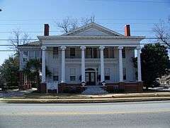 |
(#80001108) |
416 N. Ashley St. 30°50′07″N 83°16′47″W / 30.835278°N 83.279722°W |
Valdosta | |
| 2 | Brookwood North Historic District | 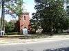 |
(#95000684) |
Roughly bounded by Patterson St., Georgia Ave., Oak St., Park Ave., Williams St. and Brookwood Dr. 30°51′06″N 83°17′16″W / 30.851667°N 83.287778°W |
Valdosta | Contributing property at 1521 N Patterson St. |
| 3 | Carnegie Library of Valdosta | 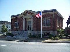 |
(#84001120) |
305 W. Central Ave. 30°49′50″N 83°16′58″W / 30.830556°N 83.282778°W |
Valdosta | Built in 1914, it now houses the Lowndes County Historical Society and Museum |
| 4 | Converse-Dalton House | 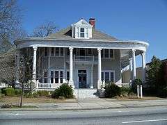 |
(#83000233) |
305 N. Patterson St. 30°49′59″N 83°16′48″W / 30.833056°N 83.28°W |
Valdosta | |
| 5 | The Crescent | 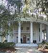 |
(#80001109) |
904 N. Paterson St. 30°50′22″N 83°17′02″W / 30.839444°N 83.283889°W |
Valdosta | |
| 6 | Crestwood | 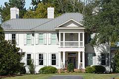 |
(#84001147) |
502 Eager Rd. 30°52′14″N 83°18′10″W / 30.87047°N 83.30272°W |
Valdosta | Built in 1915, it is down a private gated drive, but visible from public property. |
| 7 | Dasher High School | 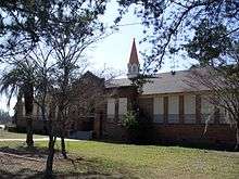 |
(#85000849) |
900 S. Troup St. 30°50′49″N 83°16′11″W / 30.846944°N 83.269722°W |
Valdosta | |
| 8 | East End Historic District | 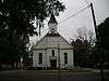 |
(#05000427) |
NE of downtown Valdosta roughly bounded by North Ashley and E. Ann Sts., East Hill Ave., and Georgia and Florida RR 30°50′19″N 83°16′25″W / 30.838611°N 83.273611°W |
Valdosta | Contributing property at 315 E Central Ave. |
| 9 | Ewell Brown General Store | 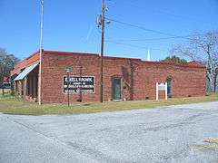 |
(#97000099) |
RR Ave., jct. with Lawrence St. 30°40′59″N 83°10′56″W / 30.68319°N 83.18216°W |
Lake Park | Now houses the Lake Park Museum |
| 10 | Fairview Historic District | 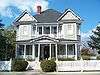 |
(#84001149) |
W. Central, Floyd, River, Varnedoe, and Wells Sts. 30°49′50″N 83°17′07″W / 30.830556°N 83.285278°W |
Valdosta | |
| 11 | First Presbyterian Church | 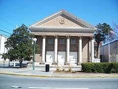 |
(#87001912) |
313 N. Patterson St. 30°50′03″N 83°16′10″W / 30.834167°N 83.269444°W |
Valdosta | |
| 13 | Lowndes County Courthouse | 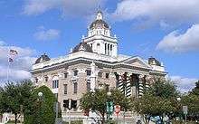 |
(#80001110) |
Central and Ashley St. 30°49′57″N 83°16′45″W / 30.8325°N 83.279167°W |
Valdosta | |
| 12 | North Patterson Street Historic District | 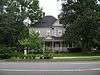 |
(#84001151) |
1003-1111 N. Patterson St. 30°50′30″N 83°17′05″W / 30.841667°N 83.284722°W |
Valdosta | |
| 14 | Southside Historic District | 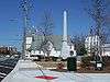 |
(#07000379) |
Roughly bounded by CSX tracks, Bunche Dr., Griffin Ave., Old Statenville Rd., Wisenbake Ln, Dasher Ln., and S. Patterson R Coordinates missing |
Valdosta | |
| 15 | Sunset Hill Cemetery | 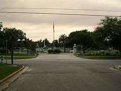 |
(#04000957) |
110 N. Oak St. 30°50′31″N 83°17′29″W / 30.841944°N 83.291389°W |
Valdosta | |
| 16 | Valdosta Commercial Historic District | 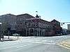 |
(#83000234) |
Roughly bounded by Savannah Ave., Lee, Toombs, and Valley Sts. 30°49′53″N 83°16′43″W / 30.831389°N 83.278611°W |
Valdosta |
References
- ↑ "National Register of Historic Places: Weekly List Actions". National Park Service, United States Department of the Interior. Retrieved on December 16, 2016.
- ↑ Numbers represent an ordering by significant words. Various colorings, defined here, differentiate National Historic Landmarks and historic districts from other NRHP buildings, structures, sites or objects.
- ↑ The eight-digit number below each date is the number assigned to each location in the National Register Information System database, which can be viewed by clicking the number.
| Wikimedia Commons has media related to National Register of Historic Places in Lowndes County, Georgia. |
This article is issued from Wikipedia - version of the 8/30/2016. The text is available under the Creative Commons Attribution/Share Alike but additional terms may apply for the media files.