Narragansett Pier Railroad
The Narragansett Pier Railroad (reporting mark NAP) is a former railroad in southern Rhode Island, running 8 miles from West Kingston to Narragansett Pier. It was built by the Hazard Family of Rhode Island to connect their textile mills in Peace Dale and Wakefield to the New York, Providence and Boston Railroad at Kingston Station as well as to ocean-going steamboats at Narragansett Pier. Passenger service ran on the line from 1876 to 1952; the line continued freight operation as a Class III railroad until 1981. It is currently a bike trail known as the William C. O'Neill Bike Path.
History

The Narragansett Pier Railroad was chartered in January 1868 and opened on July 17, 1876 from Kingston Railroad Station to Narragansett Pier.[1]
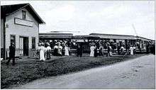
In 1890 the railway transported more than 100,000 passengers and several thousands tons of freight and luggage. An express train needed 13 minutes from Kingston to Narragansett.[2] During the Gilded Age of Newport, Rhode Island, in the 1880s and '90s, privately owned railroad coaches belonging to famous families from Philadelphia, New York and other places would arrive at Kingston Station to be transferred to the NPRR to continue on to Narragansett Pier, where their passengers would then transfer to an NPRR-owned steamboat for the short trip across Narragansett Bay to their "summer cottages" at Newport. That service ended with the sale of the steamer MANISES at the end of the 1900 season.
A famous anecdote concerning the Narragansett Pier Railroad is related in "A Short Haul to the Bay" by James N. J. Henwood (Stephen Greene Press; Brattleboro, VT, 1969). Henwood relates a supposed exchange of telegrams between the President of the Pennsylvania Railroad and John N. Hazard, president of the Narragansett Pier Rail Road. Supposedly the PRR tried to buy the NPRR. A telegram was supposedly sent to Hazard inquiring about his asking price for the NPRR. It is often claimed that his reply was some variation of : "Mine not for sale. How much for yours?"
Electric trolleys of the Sea View Line operated over the segment of the railroad between Peace Dale, Rhode Island and Narragansett Pier, Rhode Island from 1904 until 1907.[1] However, the New Haven Railroad competed with the Narragansett Pier Railroad for passengers and began secret negotiations with the Sea View Line in 1904 to attract more through passengers from Providence to the Pier to the Sea View Line. The negotiations and the subsequent contract were treated as confidential by both parties, and the required construction work at Hunt’s River Crossing was conducted on a Saturday, to minimise the amount of attention: On June 25, 1904 conflict of interests occurred, when two railway maintenance teams met quietly on a Saturday morning at the Hunt’s River Crossing on the border between North Kingstown and East Greenwich. The workers of the New Haven Railroad built two wooden passenger platforms along their tracks, while those of the Sea View Electric Trolley line installed a spur from their line down a slight grade ending alongside the newly constructed passenger platforms.[3]
From the first week of July 1904 weekend passengers could travel from Providence with four express trains each Saturday and Sunday morning and then change at Hunt's River into a waiting electric trolley express runs from there to the pier, and by the same arrangements return in the late afternoon or evening. The round trip cost only $1 in comparison to $1.25 for the ticket of the Narragansett Pier Railroad and an optional ticket upgrade included a shore dinner at a nearby Narragansett Pier hotel. Because the tram's Sea View’s Ouida Station was right next to the Pier beach house it saved the day trippers also ¾ mile of walking from the Boon Street station of the Narragansett Pier Railroad to the beach. Due to sinking passenger numbers, the Narragansett Pier Railroad cancelled its long-standing contract with the Sea View Line, whom they had allowed to use a section of the track towards Wakefield and Peace Dale.[3]
In 1907, the Sea View struck back: With the support of the New Haven Line and Marsden J. Perry’s United Electric Railway, it laid its own tracks from Sea View Junction, over the south side of Tower Hill and down the center of Main Street in Wakefield, stopping only just north of the Narragansett Pier tracks, because Narragansett Pier Railroad refused to let them cross its tracks.[3]
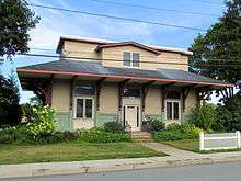
The railroad ended regular passenger service on December 31, 1952, although limited excursion service continued into the 1970s.[1] The railroad was headquartered in Peace Dale, with a two-stall roundhouse that still stands.[1]
The line's southern terminus was later cut back from Narragansett Pier, Rhode Island to Wakefield, Rhode Island, shortening the line to 6.2 miles. By 1981, the line was pared back to being just a 2-mile line between Kingston and Peace Dale, Rhode Island. During the 1970s, freight traffic consisted of fertilizer, lumber and building products.[1] Operations were suspended by 1981, and the line was never reopened.[4]
Approximately 6.8 miles of the railroad's right of way was converted into the William C. O'Neill Bike Path (formerly known as the South County Bike Path), with first phase completed in 2000 and second phase in 2003. Phase three of the project is completed to Mumford Rd. in 2011. Phase IV has started to get funding as of June 2016.[5]
External links
- Edward J. Ozog: Narragansett Pier Railroad Company
References
- 1 2 3 4 5 Lewis, Edward A. (1975). American Short Line Railway Guide. The Baggage Car. p. 87.
- ↑ Sallie W. Latimer: Narragansett By-the-Sea. Arcadia Publishing, 1. Juli 1997
- 1 2 3 G. Timothy Cranston: The View From Swamptown: South County's great rail war. The Independent, September 18, 2014.
- ↑ Lewis, Edward A. (1986). American Short Line Railway Guide. Kalmbach Books. p. 145.
- ↑ http://southcountybikepath.org/?page_id=8
| Common carriers |  | |
|---|---|---|
| Passenger carriers | ||
| Former carriers | ||
See also: List of United States railroads by political division | ||