Narasinghpur
| Narasinghpur ନରସିଂହପୁର | |
|---|---|
| Block Area | |
|
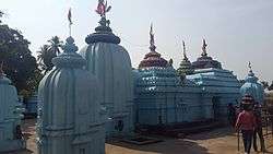
Champanath Shiva Temple | |
| Nickname(s): The Temple Town | |
 Narasinghpur  Narasinghpur  Narasinghpur | |
| Coordinates: 20°28′01″N 85°04′59″E / 20.467°N 85.083°ECoordinates: 20°28′01″N 85°04′59″E / 20.467°N 85.083°E | |
| Country | India |
| State | Odisha |
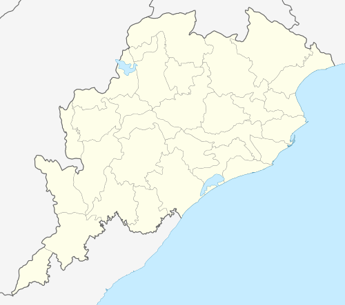
| District | Cuttack |
| Named for | Tourist Place |
| Population (2011) | |
| • Total | 10,000 |
| Languages | |
| • Official | Odia, English |
| Time zone | IST (UTC+5:30) |
| PIN | 754032 |
| Telephone code | 06721- |
| Vehicle registration | OD |
| Ethnicity | Odia people |
| Climate | Aw (Köppen) |
| Avg. summer temperature | 45 °C (113 °F) |
| Avg. winter temperature | 10 °C (50 °F) |
| https://www.facebook.com/Narasinghpur.Cuttack/ | |
| Website |
odisha |
Narasinghpur(Odia: ନରସିଂହପୁର) is a block area (Panchayat Samiti) under the subdivision of Athagad, district Cuttack, Odisha.
Narasinghpur is part of the Baramba (Odisha Vidhan Sabha constituency) which includes Baramba block and Narasinghpur block.[1][2]
Geography
Narasinghpur is situated 100 km far from capital Bhubaneswar and 120 km far from its district headquarters Cuttack. Global positioning is at 20.467La/85.083Lo. One side of Narasinghpur is painted by the perrenial giant Mahanadi River, where as the other side is escorted by the vast forest area with many mountains called Satakosia Wildlife Sanctuary.
This place is connecting to districts like Nayagarh district, Angul to its own Cuttack district.
History
Narasinghpur was the capital of Narsinghpur State, a former princely state of India during the period of the British Raj.[3]
Tourism
Narasinghpur is known as vibrant tourist place with its own charisma, pleasant ambiance and many tourist spots. Also it is known as a Temple Town. Here are few famous tourist places of the block.
- Dianjhar Waterfall- The most attractive spot inside a Forest.
- Satakoshia Gorge- A beautiful Eco tourism place surround by Riverbank of The Mahanadi, and Satakosia sanctuary.
- Maa Pragala Pitha- One of the oldest deity temple in the Forest near to Budhidei Dam.
- Baneswar Nasi- One of the Buddhist temple.
- Champanatha Pitha - A famous Shiv temple. a pond full of tortoises which attracts the tourist.
- Biswanatha Pitha
- Jagannath Temple
- Asthasambhu Temples
- Gopinatha Matha
- King's Palace
- Budha Budhi Ghati
- Raghunatha Mandira