Nantahala National Forest
| Nantahala National Forest | |
|---|---|
|
IUCN category VI (protected area with sustainable use of natural resources) | |
|
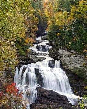
Cullasaja Falls, Nantahala National Forest, in Macon County, North Carolina | |
 | |
| Location | North Carolina, United States |
| Nearest city | Waynesville, NC |
| Coordinates | 35°14′02″N 83°33′33″W / 35.233842°N 83.559265°WCoordinates: 35°14′02″N 83°33′33″W / 35.233842°N 83.559265°W |
| Area | 531,270 acres (2,150.0 km2)[1] |
| Established | February 6, 1907[2] |
| Governing body | U.S. Forest Service |
| Website | Nantahala National Forest |
The Nantahala /næntəˈheɪlə/ [3] National Forest, established in 1920,[4] is a national forest located in the American state of North Carolina. The word "Nantahala" is a Cherokee word meaning "Land of the Noonday Sun."[4] The name is appropriate as, in some spots, the sun only reaches the floors of the deep gorges of the national forest when directly overhead at midday. The Spanish Conquistador Hernando de Soto explored the area in 1540, as did William Bartram in the 18th century. The Nantahala River flows through the Nantahala National Forest.
The Nantahala National Forest is administered by the United States Forest Service, part of the United States Department of Agriculture. The forest is managed together with the other three North Carolina National Forests (Croatan, Pisgah, and Uwharrie) from common headquarters in Asheville, North Carolina.
Overview
Nantahala National Forest is the largest of the four national forests in North Carolina,[4] lying in the mountains and valleys of western North Carolina. The terrain varies in elevation from 5,800 feet (1,767.8 m) at Lone Bald in Jackson County, to 1,200 feet (365.8 m) in Cherokee County along the Hiwassee River below the Appalachian Dam. It is the home of many western NC waterfalls. The last part of the Mountain Waters Scenic Byway travels through this forest. The total area under management is 531,270 acres (830.11 sq mi; 2,149.97 km2). In descending order of land area it is located in parts of Macon, Graham, Cherokee, Jackson, Clay, and Swain counties.
Organization
Nantahala National Forest is divided into three Ranger Districts: The Cheoah Ranger District, the Nantahala Ranger District, and the Tusquitee Ranger District. All district names come from the Cherokee language.[4]
Cheoah Ranger District
The Cheoah Ranger District has 120,110 acres (187.7 sq mi; 486.1 km2) in Graham and Swain Counties, and it is headquartered in Robbinsville, North Carolina.[5] The district's name, Cheoah, is the Cherokee word for "otter," because the lands adjoin four large mountain reservoirs and contain numerous streams.
The Appalachian Trail winds through the Cheoah Ranger District after leaving the Nantahala Ranger District on its way to the Great Smoky Mountains National Park. The district also contains the Joyce Kilmer Memorial Forest and part of the Joyce Kilmer-Slickrock Wilderness.
Nantahala Ranger District
The Nantahala Ranger District is the largest of the forest's districts, covering an area of about 250,000 acres (390.6 sq mi; 1,011.7 km2) in Macon, Jackson and Swain counties.[6] It was formed in 2007 by consolidating the former Highlands Ranger District and Wayah Ranger District.[7] The headquarters are in Franklin, North Carolina. Part of the district is adjacent to the Cherokee Indian Reservation.
This district's features include the 5,499-foot (1,676.10 m) Standing Indian Mountain, the Nantahala Gorge and Wayah Bald.
Four long distance trails pass through the district: the Appalachian, Bartram, Foothills, and Mountains-to-Sea Trails.
The district contains the 40,000-acre (62.5 sq mi; 161.9 km2) Roy Taylor Forest[8][9] located in Jackson County, southwest of and adjacent to the Blue Ridge Parkway, that it acquired in 1981. The rugged and scenic Tuckasegee Gorge is within the Roy Taylor Forest.
During the consolidation, all the lands of the former Highlands Ranger District within Transylvania County, were transferred to the Pisgah Ranger District.
Tusquitee Ranger District
The 158,348-acre (247.4 sq mi; 640.8 km2) Tusquitee Ranger District is the forest's second largest district, and it is located in far southwestern tip of North Carolina, within Cherokee and Clay Counties.[10] Tusquitee is Cherokee for "where the water dogs laughed," and the district is headquartered in Murphy, North Carolina.
The district's features include the Hiawassee River, Jackrabbit Mountain as well as Lake Chatuge, Lake Hiawassee, Lake Appalachia. All the lakes on or bordering the Tusquitee Ranger District are managed by TVA. The highest point on the district is Tusquitee Bald (5,280 feet (1,609 m)) located in Clay County.
Wilderness areas
Three Wilderness areas are located within the Nantahala National Forest. Ellicott Rock Wilderness is located near Highlands, North Carolina at the intersection of North Carolina, South Carolina and Georgia state lines, with 3,900 acres (16 km²) in the North Carolina portion. The Southern Nantahala Wilderness includes 10,900 acres (17.0 sq mi; 44.1 km2) in the North Carolina portion and lies in the Tusquitee and Nantahala Ranger Districts. Joyce Kilmer-Slickrock Wilderness which includes another 13,100 acres (53.0 km2) in North Carolina. These wilderness areas provide an opportunity for solitude in a rugged, natural setting. The Forest manages two Off - Highway Vehicle areas. The most famous being Tellico OHV area located in the Tusquitee Ranger District an additional OHV area is located in the Nantahala Ranger District. Many miles of trout water exist in the forest.
The Joyce Kilmer Memorial Forest within the National Forest was dedicated on July 30, 1936 to poet Joyce Kilmer.
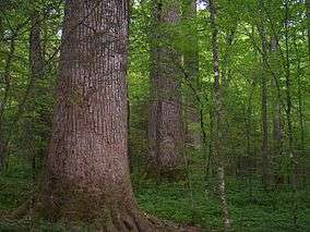
Forests and old growth
Several areas of old-growth forest have been identified in the Nantahala National Forest, totaling some 30,800 acres (125 km2).[11] The Joyce Kilmer Wilderness in particular contains nearly 6,000 acres (24 km2) of old-growth forest.
See also
References
- ↑ "Land Areas of the National Forest System" (PDF). U.S. Forest Service. January 2012. Retrieved June 28, 2012.
- ↑ "The National Forests of the United States" (PDF). ForestHistory.org. Retrieved July 28, 2012.
- ↑ Talk Like A Tarheel, from the North Carolina Collection's website at the University of North Carolina at Chapel Hill. Retrieved 2013-02-05.
- 1 2 3 4 "Nantahala National Forest". US Forest Service. Retrieved April 23, 2012.
- ↑ "Cheoah Ranger District". US Forest Service. Retrieved April 23, 2012.
- ↑ "Nantahala Ranger District". US Forest Service. Retrieved April 23, 2012.
- ↑ "Forest Service Approves Highlands- Wayah Ranger District Consolidation" (PDF). US Forest Service. February 27, 2007. pp. 1–3. Retrieved April 23, 2012.
- ↑ "Art Register for Roy Taylor Forest part of Nantahala National Forest". University of North Carolina at Asheville. Retrieved April 23, 2012.
- ↑
 PUBLIC LAW 98-11 —MAR. 28, 1983 97 STAT. 51. Wikisource. 1983.
- ↑ "Tusquitee Ranger District". US Forest Service. Retrieved April 23, 2012.
- ↑ Mary Byrd Davis (23 January 2008). "Old Gwoth in the East: A Suvey. North Carolina" (PDF).
External links
| Wikimedia Commons has media related to Nantahala National Forest. |
- Map of Nantahala National Forest
- Sherpa Guides' webpage on the Nantahala National Forest
- Franklin Chamber of Commerce page
- USDA Forest Service
- Read Congressional Research Service (CRS) Reports regarding US policy on National Forests