Nanning
| Nanning 南宁市 • Nanzningz Si | |
|---|---|
| Prefecture-level city | |
|
Clockwise from top: Nanning skyline (2008), Nanning Mosque, View from Diwang International Commerce Center, Jinhu Square, Nanning International Convention and Exhibition Center | |
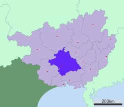 Location of Nanning City jurisdiction in Guangxi | |
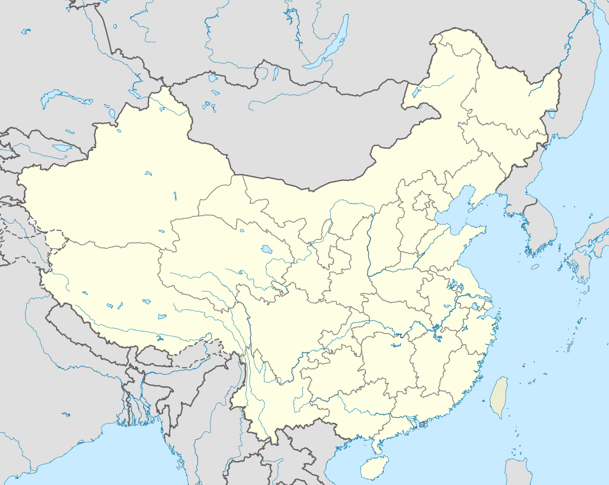 Nanning Location in China | |
| Coordinates: 22°49′N 108°19′E / 22.817°N 108.317°ECoordinates: 22°49′N 108°19′E / 22.817°N 108.317°E | |
| Country | China |
| Region | Guangxi |
| Government | |
| • Party Secretary | Wang Xiaodong |
| • Mayor | Zhou Hongbo |
| Area | |
| • Prefecture-level city | 22,189 km2 (8,567 sq mi) |
| Population (2014) | |
| • Prefecture-level city | 6,913,800 |
| • Density | 310/km2 (810/sq mi) |
| • Urban | 4,037,000 |
| Time zone | China Standard (UTC+8) |
| Postal code | 530000 |
| Area code(s) | 0771 |
| License plate prefixes | 桂A |
| Website |
nanning |

| Nanning | |||||||||||||||||||||||
|
"Nanning" in Simplified Chinese | |||||||||||||||||||||||
| Chinese name | |||||||||||||||||||||||
|---|---|---|---|---|---|---|---|---|---|---|---|---|---|---|---|---|---|---|---|---|---|---|---|
| Simplified Chinese | 南宁 | ||||||||||||||||||||||
| Traditional Chinese | 南寧 | ||||||||||||||||||||||
| Literal meaning | "Southern tranquility" | ||||||||||||||||||||||
| |||||||||||||||||||||||
| Zhuang name | |||||||||||||||||||||||
| Zhuang | Nanzningz | ||||||||||||||||||||||
| 1957 orthography | Namƨniŋƨ | ||||||||||||||||||||||

Nanning (Chinese: 南宁; pinyin: Nánníng; Zhuang: Nanzningz) is the capital of the Guangxi Zhuang Autonomous Region in southern China.[1] It is known as the "Green City" because of its abundance of lush tropical foliage. As of 2014 it had a population of 6,913,800 with 4,037,000 in its urban area. [2]
History
Nanning was once the territory of the Baiyue people and became the capital of Jinxing Prefecture which was separated from Yulin Prefecture of the Eastern Jin dynasty.
In the Yuan dynasty in 1324, it was renamed Nanning Lu (an administrative division) of Yongzhou Lu meaning "May peace maintain in the southern frontier", hence the name Nanning. Historically, Nanning was famous for trade, and had permanent business offices from other areas in China since the Song dynasty.
In the Ming dynasty Nanning developed into the commodity distributing center of the Zuo River and the You River with the reputation of "Little Nanjing".
Nanning serves as host for the annual China-ASEAN EXPO (CASEAN EXPO) which began in 2005 and was the venue for the 2006 "World Robotics Olympiad".
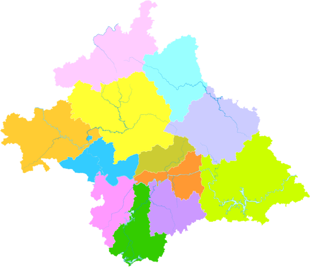
Administrative divisions
Nanning has jurisdiction over 7 districts, 5 counties, and 6 development zones.
| Map | |||||||||
|---|---|---|---|---|---|---|---|---|---|
| Divisions | Chinese | Hanyu Pinyin | Zhuang | Population (2004 est.) |
Area (km²) | Density (/km²) | |||
| City proper | |||||||||
| Qingxiu District | 青秀区 | Qīngxiù Qū | Cinghsiu Gih | 440,000 | 872 | 505 | |||
| Xingning District | 兴宁区 | Xīngníng Qū | Singhningz Gih | 260,000 | 751 | 346 | |||
| Jiangnan District | 江南区 | Jiāngnán Qū | Gyanghnanz Gih | 360,000 | 1,154 | 312 | |||
| Xixiangtang District | 西乡塘区 | Xīxiāngtáng Qū | Sihsienghdangz Gih | 660,000 | 1,118 | 590 | |||
| Liangqing District | 良庆区 | Liángqìng Qū | Liengzcing Gih | 290,000 | 1,369 | 212 | |||
| Yongning District | 邕宁区 | Yōngníng Qū | Yunghningz Gih | 320,000 | 1,295 | 247 | |||
| Suburb and Rural | |||||||||
| Wuming District | 武鸣区 | Wǔmíng Qū | Vujmingz Gih | 650,000 | 3,367 | 193 | |||
| Heng County | 横县 | Héng Xiàn | Hwngz Yen | 1,080,000 | 3,464 | 312 | |||
| Binyang County | 宾阳县 | Bīnyáng Xiàn | Binhyangz Yen | 980,000 | 2,314 | 424 | |||
| Shanglin County | 上林县 | Shànglín Xiàn | Sanglinz Yen | 460,000 | 1,876 | 245 | |||
| Long'an County | 隆安县 | Lóng'ān Xiàn | Lungzanh Yen | 370,000 | 2,264 | 163 | |||
| Mashan County | 马山县 | Mǎshān Xiàn | Majsanh Yen | 510,000 | 2,345 | 217 | |||
Development Zones:
- Nanning High-Tech Business DZ (南宁高新技术产业开发区)
- Nanning Economic and technology DZ (南宁经济技术开发区)
- Nanning Overseas Chinese Investment Zone (南宁华侨投资区)
- Nanning Qingxiu Mountain Resort/ Tourism Area (南宁青秀山风景名胜旅游区)
- Nanning Xiangsi Lake New Area (南宁相思湖新区)
- Nanning Liujing Industrial Park (南宁六景工业园区)
Cityscape
Nanning is home of the 21st tallest building[3] in the People's Republic of China, the Diwang International Commerce Center, at 276 m (906 ft), currently the tallest building in Guangxi and southwestern China (excluding Chongqing). The second tallest building in Nanning is the World Trade Commerce City at 218 meters. The city currently has seven buildings taller than 100 m (330 ft), built or under construction.
Nanning has many parks with tropical lush green landscape, it is one of the "greenest" cities in China, and it's known as "Green City"(绿城). Nanning's downtown skyline is rapidly changing and the city is becoming an important hub in China.
Recently, the government has began a city wide beautification plan which aimed to clean up the city and improve its image. This involved curtailing the number of street-side food vendors operating without proper licenses, restricting parking in busy streets, and attempting to eliminate the number of street prostitutes that appear after dark, especially west of the city and around the railway station. The program has proved successful, eliminating both the amount of rubbish on the streets and dramatically cutting down the number of ubiquitous working girls.
Economy

Nanning's GDP in 2007 was 106.3 billion RMB, which was a 17.1 percent growth over the previous year.[4] The GDP per capita was ¥15,685 (US$2,147), ranking no. 116 among 659 Chinese cities. Foreign exports in 2007 were 10 billion USD. Foreign fixed asset investment was 34.3 billion RMB. Nanning has six development zones and industrial parks, three of which accounted for 6 billion RMB of Nanning's GDP, more than 8 percent of Nanning's total.
Mineral resources include gold, iron, manganese, aluminum, quartz, silver, indium, coal, marble, and granite. One third of China's different types of mineral resources are found in Nanning.
Industrial zones
- Guilin High-tech Industrial Development Zone
- Nanning Economic & Technological Development Area
Transportation
Metro
Nanning Metro system is known for its Nanning Rail Transit (NNRT), expected to comprise a total of nine lines. The first has been completed and put into operation in June 2016, while lines 2, 3 and 4 are now under construction. Line 1 connects the East and West of Nanning, linking the financial and political center and the academic and research center of Nanning.
Stations of Line 1 from the West to East are: Shu Fu—Nan Zhi Yuan—Peng Fei— Xi Xiang Tang Coach Station—Minzu Daxue— Qing Chuan—Nanning Zoo— Lu Ban Road—Guangxi University— Bai Cang Ling—Train Station— Chao Yang Plaza—Xin Min Road—Minzu Plaza—Ma Cun,—Nan Hu— Jin Hu Plaza—International Expo—MixCity—China-ASEAN busines center—Feng Lin—Lang Dong Coach Station—Bai Hua Lin—Fo Zi Lin—Nanning East Train Station.
Air
Rail
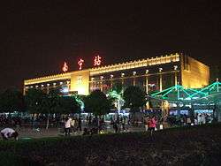
Nanning railway station is a railway junction for the Nanning–Kunming, Nanning–Guangzhou and Hunan–Guangxi Railways. There are also plans to build a high-speed railway to Pingxiang on the Vietnamese border.[5] The goal is to better integrate Pan-Pearl River Delta and southeast China with members of the ASEAN.[6]
At the end of 2013, some high-speed service has been introduced on the Hunan–Guangxi Railway and on the railway line that connects Nanning with Beihai (as well as its branch to Fangchenggang).[7][8]
Guangxi is also a conjunction of Guangdong-Guiyang Highspeed Rail.
Highways
Flora and fauna
Nanning's warm climate gives it a large amount of biodiversity. There are many species of animals and more than 3,000 species of plants. The city flower is the Jaba flower, an evergreen shrub, and the city tree is the almond tree which is regarded as the backbone tree used for greening and landscaping throughout the city.
Geography
Nanning is located in the southern part of the Guangxi Zhuang Autonomous Region, 160 km (99 mi) from the border with Vietnam. It has an administrative area of 22,293 km2 (8,607 sq mi).[9]
Nanning is situated in a hilly basin with elevations between 70 and 500 m (230 and 1,640 ft) above sea-level. Qingxiu Mountain dominates the southern part of town.
Climate
| Nanning | ||||||||||||||||||||||||||||||||||||||||||||||||||||||||||||
|---|---|---|---|---|---|---|---|---|---|---|---|---|---|---|---|---|---|---|---|---|---|---|---|---|---|---|---|---|---|---|---|---|---|---|---|---|---|---|---|---|---|---|---|---|---|---|---|---|---|---|---|---|---|---|---|---|---|---|---|---|
| Climate chart (explanation) | ||||||||||||||||||||||||||||||||||||||||||||||||||||||||||||
| ||||||||||||||||||||||||||||||||||||||||||||||||||||||||||||
| ||||||||||||||||||||||||||||||||||||||||||||||||||||||||||||
Nanning has a warm, monsoon-influenced humid subtropical climate (Köppen Cfa), with an annual mean temperature of 21.82 °C (71.3 °F). Summers are hot and humid with July, the hottest month, having a 24-hour average temperature of 28.4 °C (83.1 °F). Winters are mild and somewhat damp with January, the coolest month, averaging 12.9 °C (55.2 °F) in January. From February to August, rain is most frequent and relative humidity consistently averages above 80 percent; the annual rainfall is 1,310 millimetres (51.6 in). The area is also frost-free for all but 3 or 4 days a year and snowfall is virtually unheard of in the city, with a unique exception since 1900: in December 1975 snow fell on the city albeit without sticking to the ground. Extreme temperatures have ranged from −2.1 to 40.4 °C (28 to 105 °F).[10] With monthly percent possible sunshine ranging from 17 percent in March to 51 percent in September, the city receives 1,585 hours of bright sunshine annually.
| Climate data for Nanning (normals 1971−2000, extremes 1951−2010) | |||||||||||||
|---|---|---|---|---|---|---|---|---|---|---|---|---|---|
| Month | Jan | Feb | Mar | Apr | May | Jun | Jul | Aug | Sep | Oct | Nov | Dec | Year |
| Record high °C (°F) | 32.6 (90.7) |
36.2 (97.2) |
35.5 (95.9) |
38.3 (100.9) |
40.4 (104.7) |
37.9 (100.2) |
39.0 (102.2) |
39.1 (102.4) |
38.2 (100.8) |
35.2 (95.4) |
33.7 (92.7) |
30.5 (86.9) |
40.4 (104.7) |
| Average high °C (°F) | 16.9 (62.4) |
18.0 (64.4) |
25.5 (77.9) |
27.6 (81.7) |
30.4 (86.7) |
32.1 (89.8) |
32.9 (91.2) |
32.7 (90.9) |
31.6 (88.9) |
28.4 (83.1) |
24.1 (75.4) |
20.2 (68.4) |
26.3 (79.3) |
| Daily mean °C (°F) | 12.9 (55.2) |
14.1 (57.4) |
17.7 (63.9) |
22.5 (72.5) |
25.9 (78.6) |
27.9 (82.2) |
28.4 (83.1) |
28.2 (82.8) |
26.9 (80.4) |
23.5 (74.3) |
18.9 (66) |
14.9 (58.8) |
21.8 (71.2) |
| Average low °C (°F) | 10.0 (50) |
11.5 (52.7) |
15.0 (59) |
19.6 (67.3) |
22.8 (73) |
24.9 (76.8) |
25.4 (77.7) |
25.2 (77.4) |
23.6 (74.5) |
20.2 (68.4) |
15.3 (59.5) |
11.3 (52.3) |
18.7 (65.7) |
| Record low °C (°F) | −2.1 (28.2) |
0.2 (32.4) |
3.7 (38.7) |
9.2 (48.6) |
13.5 (56.3) |
18.2 (64.8) |
19.7 (67.5) |
19.9 (67.8) |
15.4 (59.7) |
6.9 (44.4) |
0.7 (33.3) |
−1.9 (28.6) |
−2.1 (28.2) |
| Average rainfall mm (inches) | 35.3 (1.39) |
42.6 (1.677) |
59.4 (2.339) |
97.1 (3.823) |
185.6 (7.307) |
207.1 (8.154) |
218.8 (8.614) |
205.3 (8.083) |
128.3 (5.051) |
65.5 (2.579) |
40.3 (1.587) |
24.5 (0.965) |
1,309.8 (51.569) |
| Average rainy days (≥ 0.1 mm) | 11.1 | 13.2 | 13.8 | 13.6 | 16.6 | 16.3 | 16.8 | 16.2 | 10.5 | 8.5 | 6.8 | 5.9 | 149.3 |
| Average relative humidity (%) | 78 | 81 | 82 | 81 | 80 | 82 | 82 | 82 | 78 | 75 | 74 | 74 | 79.1 |
| Mean monthly sunshine hours | 69.6 | 56.7 | 61.8 | 91.4 | 144.0 | 161.1 | 196.8 | 186.1 | 185.6 | 163.7 | 144.2 | 123.7 | 1,584.7 |
| Percent possible sunshine | 21 | 18 | 17 | 24 | 35 | 40 | 48 | 47 | 51 | 46 | 44 | 37 | 35.7 |
| Source: China Meteorological Administration,[11] all-time extreme temperature[10] | |||||||||||||
Demographics
At 2010 census, the total population of Nanning was 6,611,600, among which 2,875,220 were urban residents (after the adjustment of administrative divisions) and 2,480,340 in the built up area made of 5 out of 6 urban districts.[12] Nanning is a city in which Zhuang ethnic group live in compact communities. Thirty-five ethnic groups live in compact communities in Nanning, including people of Zhuang, Han, Yao, Hui, Miao, Dong, and Man minorities.
Culture
Nanning is the center of science and technology, education, culture and health in Guangxi Zhuang Autonomous Region. There are altogether 54 scientific research institutes subordinate to districts. 10 colleges and 50 trade schools are training specialised personnel of all kinds. Now there are 62 mass cultural organizations, 13 performing groups, 8 cinemas, 285 projecting units, over 70 karaoke halls and over 1000 newsstands. Bookshops and cultural markets can be found everywhere.
Food
Nanning has not only local cuisine but also food from other areas of China and abroad. Traditional food culture can be found around most streets of Nanning. Nanning food shares the style of Cantonese food and of Southeast Asia. Chinese cuisine including Guangdong, Szechuan, Hunan and Jiangsu as well as Japanese, Thai and Western cuisines can be found.
Rice noodles are very popular among the Nanning people. Laoyou rice noodles are the most famous, while other noodle dishes such as Guilin rice noodles and hand made noodles can be found. Laoyou rice noodles (means old friend rice noodles) made of fry up pepper, sour bamboo shots, black beans and garlic, then pork, and then soup and rice noodles. The sour spicy tasted noodles are very popular and cheep favorable street food for all meals in nanning. (breadfast, lunch, dinner)
Tourism
Nanning is close to scenic Guilin, with its world-famous hillscape, northern and western Guangxi and its minority villages, and the border with Vietnam in the south.
Tourist attractions in Nanning include Guangxi Museum, People's Park with the Zhenning Fort, Mount Qingxiu, Guangxi Medicinal Herb Botanical Garden,[13] and Yangmei Ancient Town.[14]
Other places of interest include Nanhu Park, Shishan Park and Nanning Zoo.
Colleges and universities
- Guangxi Arts College
- Guangxi Medical University
- Guangxi Teachers College (founded 1953)
- Guangxi University (founded 1928) includes Xingjian College (as of 2005)
- Guangxi University of Chinese Medicine (广西中医药大学) (founded 1956)
- Guangxi University of Finance and Economics
- Guangxi University for Nationalities
Note: Institutions without full-time bachelor programs are not listed.
See also
References
- ↑ "Illuminating China's Provinces, Municipalities and Autonomous Regions". PRC Central Government Official Website. Retrieved 2014-05-17.
- ↑ "3-5主要年份各市按居住地分的城乡人口(2005-2014年)-数析网". www.tjsql.com. Retrieved 2016-03-06.
- ↑ According to the table on List of tallest buildings in the People's Republic of China
- ↑ 艳梅, 黄; 志雄, 杨 (25 March 2008). "2007南宁市GDP总量首次突破一千亿元人民币". 中新广西网 (in Chinese). Retrieved 23 July 2015.
- ↑ "High-speed railway to boost trade". Retrieved 19 February 2011.
- ↑ "China starts construction of Nanning-Guangzhou high-speed rail line". Xinhua. 9 November 2008. Retrieved 28 August 2010.
- ↑ Nanning train schedule (Chinese)
- ↑ 广西再开通运营9对动车组 陈武宣布高铁开通 (Guangxi opens new CRH service, with 9 pairs of train a day. Chen Wu announces the opening of high-speed service), 2013-12-31
- ↑ "Profile of Nanning" (in Chinese). Archived from the original on 10 June 2008. Retrieved 11 June 2008.
- 1 2 "Extreme Temperatures Around the World". Retrieved 2013-02-21.
- ↑ 中国气象局 国家气象信息中心 (in Chinese). China Meteorological Administration. Retrieved 2010-05-04.
- ↑ 南宁市2010年第六次全国人口普查主要数据公报. 广西壮族自治区统计局 (in Chinese). 南宁市统计局. 6 July 2011.
- ↑ China's Southwest. Lonely Planet. 2007. p. 192. ISBN 978-1-74104-185-9.
- ↑ Ancient Town of Yangmei
External links
| Wikimedia Commons has media related to Nanning. |
|  | |