Nankai megathrust earthquakes
Nankai megathrust earthquakes are great megathrust earthquakes that occur along the Nankai megathrust – the fault under the Nankai Trough – which forms the plate interface between the subducting Philippine Sea Plate and the overriding Amurian Plate (part of the Eurasian Plate), which dips beneath southwestern Honshu, Japan. The fault is divided into five segments in three zones, which rupture separately or in combination, and depending on location, the resulting earthquakes are subdivided by zone from west to east into Nankai earthquakes, Tōnankai earthquakes, and Tōkai earthquakes.
The earthquakes occur with a return period of about 90–200 years, and often occur in pairs, where a rupture along part of the fault is followed by a rupture elsewhere, notably the 1854 Ansei-Tōkai earthquake and the 1854 Ansei-Nankai earthquake the next day, and the 1944 Tōnankai earthquake, followed by the 1946 Nankaidō earthquake. In one recorded case (the 1707 Hōei earthquake) the fault ruptured along its entire length. All of these great earthquakes have resulted in damaging tsunamis, which are particularly damaging due to the Japanese population being concentrated on the Taiheiyō Belt, especially the coastal cities of Tokyo and Osaka, the two most populous in Japan. The area remains seismically active, and future earthquakes are anticipated, with a high risk of a Nankai earthquake in the near future, which could be potentially very damaging.
Tectonic setting
The Nankai Trough is the surface expression of the subduction zone between the Philippine Sea and Amur plates. Honshu itself is formed from the island arc developed over the subducting plate.[1] The megathrust boundary extends about 700 km from the southern end of Kyūshū to the triple junction with the Okhotsk Plate near Mount Fuji. At its southwestern end, there is another triple junction, where the overriding plate becomes the Okinawa Plate.[2]
Megathrust geometry
The megathrust dip increases from about 5° near the surface to 10° as it passes beneath the coast of Honshu. Analysis of seismic reflection data suggests that some of the displacement is carried by a splay fault dipping at about 25°.[3] This 'megasplay' fault system has caused an unusually thick section of fluid-rich sedimentary rocks to be deeply underthrust. The presence of this 'weak' zone may lead to shallow coseismic rupture along the megasplay faults during megathrust earthquakes, explaining the large tsunamis created by these events.[4]
Historical seismicity
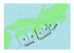

The Nankai megathrust is thought to have caused at least 12 major earthquakes in the last ca. 1300 years. The pattern of historical seismicity reveals that the megathrust surface is segmented, with five separate zones of rupturing identified, conventionally labelled A–E, from west to east.[5] Earthquakes involving the A+B segments are generally referred to as Nankai (literally South Sea) earthquakes, C+D Tonankai (literally Southeast Sea) earthquakes and C+D+E Tokai (literally East Sea) earthquakes. The earthquake repeat intervals are generally in the range 90–200 years.
On all but one occasion, rupture of segment C (±D ±E) has been followed by rupture of segments A+B within a few years. This behaviour has been reproduced by modelling the viscoelastic response of the megathrust fault plane with lateral variations in both convergence rate and frictional properties.[5]
Future earthquake risk
The northeastern most part of the megathrust, segment E, has not ruptured since 1854. A future great earthquake involving rupture along this and possibly other segments has been proposed as a major risk for the southern coast of Honshu.[6] In 1999, the likelihood of the occurrence of a great earthquake in the Tokai area in the period 2000-2010 was estimated to be in the range of 0.35.–0.45.[7] Despite the uncertainty of when such an earthquake will occur, local authorities are already taking action to prepare residents for what they regard as an inevitability.[8]
List of occurrences
See also
References
- ↑ Taira, A. (2001). "Tectonic evolution of the Japaneses island arc system" (PDF). Annu. Rev. Earth Planet. Sci. 29: 109–134. Bibcode:2001AREPS..29..109T. doi:10.1146/annurev.earth.29.1.109. Retrieved 2009-12-06.
- ↑ Neall, V.E.; Trewick S.A. (2008). "The age and origin of the Pacific islands: a geological overview". Philos Trans R Soc Lond B Biol Sci. 363 (1508): 3293–3308. doi:10.1098/rstb.2008.0119. PMC 2607379
 . PMID 18768382.
 - ↑ Cummins, P.R.; Hori T.; Kaneda Y. (2001). "Splay fault and megathrust earthquake slip in the Nankai Trough" (PDF). Earth Planets Space. 53 (4): 243–248. Bibcode:2001EP&S...53..243C. doi:10.1186/BF03352381. Retrieved 2009-12-01.
- ↑ Bangs, N.L.B.; Moore G.G.; Gulick S.P.S.; Pangborn E.M.; Tobin H.J.; Kuramoto S.; Taira A. (2009). "Broad, weak regions of the Nankai Megathrust and implications for shallow coseismic slip" (PDF). Earth and Planetary Science Letters. 284: 44. Bibcode:2009E&PSL.284...44B. doi:10.1016/j.epsl.2009.04.026. Retrieved 2009-12-01.
- 1 2 Hirahara, K.; Kato N.; Miyatake T.; Hori T.; Hyodo M.; Inn J.; Mitsui N.; Sasaki T.; Miyamura T.; Nakama Y.; Kanai T. (2004). "Simulation of Earthquake Generation Process in a Complex System of Faults" (PDF). Annual Report of the Earth Simulator Center April 2004 - March 2005. pp. 121–126. Retrieved 2009-11-14.
- ↑ Ando, M. (1975). "Source mechanisms and tectonic significance of historical earthquakes along the Nankai Trough, Japan". Tectonophysics. 27 (2): 119–140. Bibcode:1975Tectp..27..119A. doi:10.1016/0040-1951(75)90102-X. Retrieved 2009-11-13.
- ↑ Rikitake, T (1999). "Probability of a great earthquake to recur in the Tokai district, Japan:" (PDF). Earth Planets Space. 51: 147–157. Bibcode:1999EP&S...51..147R. Retrieved 2009-12-05.
- ↑ Yamanashi Prefectural Disaster Prevention Safety Center. "A Disaster Prevention and Earthquake Experience Guide" (PDF). Retrieved 5 December 2009.
- 1 2 3 4 5 6 7 8 9 10 National Geophysics Data Center. "NGDC Tsunami Event Database". Retrieved 2009-11-13.
- 1 2 3 4 5 6 7 8 9 10 11 12 13 IISEE. "Catalog of Damaging Earthquakes in the World (Through 2007)". Retrieved 2009-11-13.
- 1 2 3 4 5 6 7 8 9 10 11 12 13 Yonekura, N. (1975). "Quaternary tectonic movements in the outer arc on southwest Japan with special reference to seismic crustal deformation". Bulletin Department of Geography University of Tokyo. 7: 19–71.