Nagarparkar
| نگرپاركر | |
|---|---|
| City | |
| Nagarparkar | |
|
Nagarparkar City view from Karoonjhar Mountains | |
| Country | Pakistan |
| Province | Sindh |
| District | Tharparkar |
| Time zone | PST |

Nagarparkar (Urdu: نگرپاركر, Sindhi: ننگرپارڪر), an ancient Hindu and Jain pilgrimage site, is a town in Tharparkar District in Sindh province of Pakistan. Located at a distance of 129 km from Mithi, in Sindh, Pakistan.
Description
The town name comes from the original word Nangar Parkar. It is at the foot of the Karoonjhar Hills. It is situated at a distance of about 16 km from south and about 23 from east from the Indian border. At one time the area was under the sea, which had to be crossed; the name "Parkar" means "to cross over". Nagarparkar has Taluka Chachro on its north, and on its west is Taluka Mithi of Tharparkar District, while on east of it lies Barmer (Rajasthan) and on its south is Rann Kachchh. The area surrounding the city is a rocky belt called Parkar, and the remaining part is a sandy area.
The Karoonjhar hills surround Nagarparkar for 16 miles. The granite stone of this mountain is used for making tiles. There is a saying that the Karoonjhar hills provide 1-1/4 kilos of gold every day in the form of red granite stone, china clay, and honey. In summer, different sounds are audible from the rock due to sulphur deposits.
History
During the Indo-Pak war of 1965, Indian Army had captured the hills of Nagarparkar. After the cease-fire was declared and international border was being carved out with the help of Iran and Yugoslavia, India relinquish the control of Nagarparkar hills as per the treaty.[1]
Nagarparkar Temples

The region once had a significant Jain population. Shri Gaudi Parshvanth Stavan describes the Parkar country as the most glorious of all regions of India.[2] The remains of a number of Jain temples are popular tourist attractions and heritage sites in the region.[3]
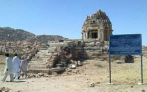
Nagar Bazaar temple
Nagar Bazaar temple is present in the main bazar of the Nangar Parkar town. The structure of the temple, including the shikhar and the torana gateway is completely intact. It was apparently in use until the independence of Pakistan in 1947, and perhaps for some years even after that. There is also a ruined temple outside of the town.
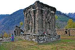
Bhodesar Jain temples
Bhodesar Jain mandir, 7.2 km from Nagar, was the region's capital during Sodha rule. Remains of three temples, are present. In 1897, two of them were being used as cattle stalls and the third had holes in the back. The oldest temple, was built in the classical style with stones without any mortar, built around 9th century. It is built on a high platform and reached by a series of steps carved into the rock. It has beautifully carved huge stone columns and other structural elements. The remaining walls are unstable and partially collapsed. Parts of the building had been dismantled by the locals who used the bricks to construct their homes. It is perhaps the most spectacular of the monuments in Sindh. The two other Jain temples are said to have been built in 1375 CE and 1449 CE built of kanjur and redstone, with fine carvings and corbelled domes.
Karoonjar Jain temple
Karoonjar Jain mandir is at the base of the mountain.
Viravah Jain mandir
Virvah Jain mandir, are a number of ruins of Jain temples here. One of the temples had 27 devakulikas in it. The ruins of legendary Parinagar are nearby. One of the temples is in good preservation.
Virvah Gori mandir
Virvah Gori mandir is 14 miles from Viravah. The legendary temple with 52 subsidiary shrines was built in AD 1375-6. It is dedicated to Hindu goddess Gori.
Durga mandir
Nagarparkar Durga mandir, on top of the hill, commonly known as Churrio Jabal or Churrio Hill, is dedicated to the Hindu goddess Durga.
Bhudesar Mosque

The Bhudesar Mosque was built by Nasir-ud-Din Mahmud Shah of Gujarat in 1505 AD. It is built in the Hindu/Jain architect style.
Demographics
The population of the taluka is 153,106, out of which 90,893 are Hindus and 62,213 are Muslims. There is one rest house beneath the Karoonjhar Mountain, but it partially collapsed during the 2001 earthquake. The town is an ancient place of Hindu worship. Sardharo, Anchlesar, and Jain temples are situated there.
Climate
Rainfall
Average annual rainfall for the Nagarparkar based on available data
recorded at various stations in the area for the period 1926-2009 is of
the order of 340 mm (13.4inches). The maximum annual rainfall of
1,600mm was recorded in year 2011.
Average monthly rainfall is given below:
Month Average Monthly rainfall
January 2.28
February 2.09
March 2.10
April 1.11
May 3.39
June 28.32
July 137.34
August 101.92
September 49.82
October 5.20
November 3.02
December 0.84
Total 337.32 mm
Climatic Conditions
The Nagarparkar is usually hot during summer when temperature
varies form 40°C to 45°C
542°C
. In winter, the weather is mild with temperature
between 5°C to 15°C
. The maximum and minimum temperatures and
evaporation losses during various months of the year are given
below:
Month
Mean Temperature oC Evaporation (mm)
Maximum Minimum Maximum Minimum
January 7.80 3.20 80.70 32.30
February 15.30 4.50 103.14 42.00
March 24.20 5.00 147.26 90.20
April 32.20 10.20 211.00 145.50
May 37.80 17.40 280.27 209.20
June 45.20 31.00 329.53 272.50
July 47.80 33.20 323.81 276.30
August 41.40 31.40 304.15 240.00
September 37.20 15.00 244.00 178.20
October 32.10 13.70 215.51 162.70
November 22.10 8.90 155.51 87.50
December 10.80 2.90 100.08 37.40
External links
-
 Nagarparkar travel guide from Wikivoyage
Coordinates: 24°21′00″N 70°47′00″E / 24.35°N 70.7833°E
See also
References
- ↑ "NATIONAL SECURITY: BSF in Mysterious Rann of Kutch (रण का रहस्य)". Rajya Sabha TV. Rajya Sabha TV. 18 March 2015. Retrieved 8 February 2016.
- ↑ Shri Gaudi Parshvanth Stavan, Bhanvarlal Nahta, Shri Gaudi Parchvanath Tirth, Muni Jinavijaya Abhinandan Granth, Ed. Dalsukh Malvania, Jinavijayaji Samman Samiti, Jaipur, 1971, p. 263-275
- ↑ Vanishing temples of Thar and Nagar Parkar, Ameer Hamza, Dawn, October 21, 2006 http://archives.dawn.com/weekly/gallery/archive/061021/gallery3.htm
| Shakti Peethas |
|  | |||||||||||||||||||||||||||||
|---|---|---|---|---|---|---|---|---|---|---|---|---|---|---|---|---|---|---|---|---|---|---|---|---|---|---|---|---|---|---|---|
| Notable temples |
| ||||||||||||||||||||||||||||||
| History |  | |
|---|---|---|
| Deities | ||
| Texts | ||
| Mantra/ Stotra | ||
| Philosophies | ||
| Jyotirlingas | ||
| Temples | ||
| Traditions | ||
| ||