Nandalur
| Nandalur | |
|---|---|
| Village | |
|
Sri Soumyanatha Swamy temple, Nandalur | |
 Nandalur  Nandalur Location in Andhra Pradesh, India | |
| Coordinates: 14°15′00″N 79°07′00″E / 14.2500°N 79.1167°ECoordinates: 14°15′00″N 79°07′00″E / 14.2500°N 79.1167°E | |
| Country | India |
| State | Andhra Pradesh |
| District | Kadapa |
| Talukas | Nandalur |
| Government | |
| • Type | Andrapradesh |
| Elevation | 151 m (495 ft) |
| Languages | |
| • Official | Telugu |
| Time zone | IST (UTC+5:30) |
| PIN | 516150 |
| Telephone code | +91–8565 |

Nandalur is a village in Kadapa district of the Indian state of Andhra Pradesh. It is located in Nandalur mandal of Rajampet revenue division.[1]
Geography and climate
| Nandalur
Period – 1951–2000 | ||||||||||||||||||||||||||||||||||||||||||||||||||||||||||||
|---|---|---|---|---|---|---|---|---|---|---|---|---|---|---|---|---|---|---|---|---|---|---|---|---|---|---|---|---|---|---|---|---|---|---|---|---|---|---|---|---|---|---|---|---|---|---|---|---|---|---|---|---|---|---|---|---|---|---|---|---|
| Climate chart (explanation) | ||||||||||||||||||||||||||||||||||||||||||||||||||||||||||||
| ||||||||||||||||||||||||||||||||||||||||||||||||||||||||||||
| ||||||||||||||||||||||||||||||||||||||||||||||||||||||||||||
Nandalur is located at 14°15′00″N 79°07′00″E / 14.2500°N 79.1167°E.[2] It is 10 kilometers from Rajampet and 42 kilometers from the District headquarters of the Cuddapah district on the State Highway connecting Cuddapah with Tirupati. It is also close to other pilgrimage centres in Cuddapah district like Ontimitta, Polatala, Attirala and the famed birthplace of Sri Annamacharya, Tallapaka. It has an average elevation of 151 meters (498 feet). Nandalur is on the west bank of the Cheyyeru river.
References
- ↑ "Revenue Divisions and Mandals". Official website of YSR Kadapa District. National Informatics Centre- Kadapa, Andhra Pradesh. Retrieved 23 May 2015.
- ↑ Falling Rain Genomics.Nandalur
External links
| Wikimedia Commons has media related to Nandalur. |
| Anantapur | 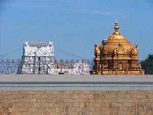 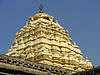  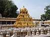  | |
|---|---|---|
| Chittor | ||
| East Godavari | ||
| Guntur | ||
| Kadapa | ||
| Krishna | ||
| Kurnool | ||
| Nellore | ||
| Prakasam | ||
| Srikakulam | ||
| Visakhapatnam | ||
| Vizianagaram | ||
| West Godavari | ||
This article is issued from Wikipedia - version of the 8/27/2016. The text is available under the Creative Commons Attribution/Share Alike but additional terms may apply for the media files.