Nampo
| Namp'o 남포시 | |
|---|---|
| Special city | |
| 남포특별시 | |
| Korean transcription(s) | |
| • Chosŏn'gŭl | 남포특별시 |
| • Hancha | 南浦特別市 |
| • McCune-Reischauer | Namp'o-t'ŭkpyŏlsi |
| • Revised Romanization | Nampo-teukbyeolsi |
|
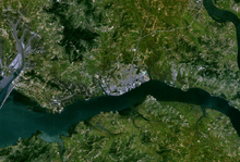
Views of Nampo | |
 | |
| Country |
|
| Province | South P'yŏngan |
| Area | |
| • Total | 829 km2 (320 sq mi) |
| Population (2008) | |
| • Total | 366,815 [1] |
| • Dialect | P'yŏngan |

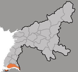
Namp'o (North Korean official spelling: Nampo; pronounced [nampʰo]) is a city and seaport in South Pyongan Province, North Korea. Namp'o lies on the northern shore of the Taedong River, 15 km east of the river's mouth. It was a provincial-level "Directly Governed City" ("Chikhalsi") from 1980 to 2004 and was designated a "Special City" ("T'ŭkgŭpsi"; tŭkpyŏlsi; 특별시; 特別市), in 2010 and made a part of South P'yŏngan. Namp'o is approximately 50 km southwest of P'yŏngyang, at the mouth of the Taedong River.
Namp'o was originally a small fishing village that became a port for foreign trade in 1897, developing into a modern port in 1945 after World War II. With the rapid increase in state investment, the city's industrial capacity grew. Some of the city's industrial facilities include the Namp'o Smelter Complex, the Namp'o Glass Corporation, the Namp'o Shipbuilding Complex, the Namp'o Fishery Complex, and other central and local factories. Namp'o is a center for the DPRK shipbuilding industry. North of the city are facilities for freight transportation, aquatic products, and fishery, and a sea salt factory. Apples grown in the city's Ryonggang district (룡강군) are a famous local product.[2][3]
Administrative divisions
Namp'o is divided into 5 kuyŏk and 2 kun, which are in turn subdivided into tong and ri:
|
Climate
| Climate data for Namp'o | |||||||||||||
|---|---|---|---|---|---|---|---|---|---|---|---|---|---|
| Month | Jan | Feb | Mar | Apr | May | Jun | Jul | Aug | Sep | Oct | Nov | Dec | Year |
| Average high °C (°F) | −2 (28) |
1 (33) |
7 (44) |
14 (58) |
21 (69) |
24 (76) |
27 (80) |
27 (81) |
23 (74) |
17 (63) |
9 (48) |
2 (35) |
14 (58) |
| Average low °C (°F) | −8 (18) |
−6 (22) |
0 (32) |
6 (43) |
12 (54) |
17 (63) |
21 (70) |
21 (70) |
16 (61) |
9 (49) |
2 (36) |
−4 (24) |
8 (46) |
| Average precipitation mm (inches) | 13 (0.5) |
13 (0.5) |
30 (1) |
43 (1.7) |
71 (2.8) |
81 (3.2) |
262 (10.3) |
221 (8.7) |
109 (4.3) |
43 (1.7) |
41 (1.6) |
20 (0.8) |
942 (37.1) |
| Source: Weatherbase[5] | |||||||||||||
Transportation
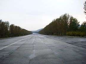
Road
The Youth Hero Motorway that connects Namp'o to P'yŏngyang.
Air
Onch'ŏn Airport in Onch'ŏn-gun serves Namp'o Special City; Air Koryo operates charter flights from here.
Rail
The greater Namp'o area is densely served by the Korean State Railway, with 18 stations on the P'yŏngnam Line, the entirety of the Ryonggang Sŏhaekammun and Taean lines, and one station on the Ŭllyul Line being located inside the boundaries of Namp'o-t'ŭkpyŏlsi.
Sea
The West Sea Barrage of the port of Namp'o, built by erecting an 8-km long sea wall, has three lock chambers which allow the passage of ships up to 50,000 tons, and 36 sluices. Namp'o Harbour is often used as the primary port of call for the reception of foreign food aid assistance into North Korea.
In 2008, the harbour received several batches of grain delivery; the first batch delivered in June was sent by the United States and weighed 38,000 tons. A South Korean-based relief organisation, Join Together Society, donated one batch of flour in October of the same year weighing approximately 500 tons.[6] The port of Namp'o has modern harbour facilities that can accommodate ships of 20,000 tons but is frozen during the winter. Namp'o serves as Pyongyang's port on the Yellow Sea.
Education
Institutes of higher learning in Namp'o include
- Namp'o University
- Sŏhae University
- Samgwang College
- Sunhwa College
- Namp'o University of Medicine
- Namp'o University of Agriculture
- Namp'o College of Shipping Industry
- Namp'o Building Materials College
- Namp'o University of Fisheries
Other
Tourist attractions include Waudo Pleasure Ground, with a beach, a convalescent hospital and recreation facilities. Nearby scenic spots include the West Sea Barrage, three tombs in Kangsŏ, the tomb in Tokhung-dong, Susan Spa, Chongsan Spa, Kangsŏ Mineral Springs and Lake T'aesang.
Sister cities
See also
Notes
- ↑ DPR Korean Central Bureau of Statistics: 2008 Population Census (2008 population census, published in 2009)
- ↑ 남포직할시. 한국민족대백과사전 (in Korean). Retrieved 11 November 2006.
- ↑ Kim, Nam-yong (金南龍). 남포직할시. Korean Britannica (in Korean). Retrieved 11 November 2006.
- ↑ Kim So Yeol (15 February 2011). "North Korea Splits No. 38 and 39 Departments Up Again". Daily NK. Retrieved 15 November 2012.
- ↑ "Weatherbase: Historical Weather for Namp'o, North Korea". Weatherbase. 2011.; retrieved 24 November 2011.
- ↑ KINU White paper on human rights in North Korea, 2009 (Chapter G. Human Rights Violations Inside Political Concentration Camps (Kwanliso), p. 125)
Further reading
- Dormels, Rainer. North Korea's Cities: Industrial facilities, internal structures and typification. Jimoondang, 2014. ISBN 978-89-6297-167-5
External links
| Wikivoyage has a travel guide for Nampho. |
| Wikimedia Commons has media related to Nampo. |
- Korea Tourist Map (English, Korean, Japanese, Chinese)
- North Korea Uncovered, North Korea Google Earth: labels most of Namp'o's infrastructure locations including hotels, nearby UNESCO sites, railroads, West Sea Barge, electricity grid, and shipping facilities.
- joins.com (Korean) Has maps of most of North Korea, including districts and villages.
- Nampo City (North Korea) on YouTube
- North Korea – Passing through Nampo (DPRK) on YouTube
- Rainer Dormels - North Korea's Cities, 2014; Profiles of the cities of DPR Korea – Nampho Profiles of the cities of DPR Korea – Nampho
| Regions | |
|---|---|
| Provinces | |
| Direct-administered city | |
| Special cities | |
| Special administrative regions | |
Coordinates: 38°44′N 125°24′E / 38.733°N 125.400°E