Nakusp
| Nakusp | |
|---|---|
| Village | |
| Village of Nakusp[1] | |
 Nakusp Location of Nakusp in British Columbia | |
| Coordinates: 50°14′36″N 117°48′1″W / 50.24333°N 117.80028°W | |
| Country |
|
| Province |
|
| Region | Arrow Lakes, West Kootenay |
| Regional district | Central Kootenay |
| Founded | 1892 |
| Incorporated | 1964 |
| Government | |
| • Governing body | Nakusp Village Council |
| • Mayor | Karen Hamling |
| Area | |
| • Total | 8.05 km2 (3.11 sq mi) |
| Elevation | 457.2 m (1,500.0 ft) |
| Population (2011) | |
| • Total | 1,574 [2] |
| • Density | 195.2/km2 (506/sq mi) |
| Time zone | PST (UTC-8) |
| Area code(s) | 250 / 778 / 236 |
| Highways | 6, 23 |
| Website | Village of Nakusp |
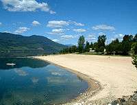
The Village of Nakusp /nəˈkʌsp/ (Sinixt neqo'sp,[3]) is a village located on the shores of Upper Arrow Lake, a portion of the Columbia River, in the West Kootenay region of British Columbia. It has a population of around 1,574, and it is known primarily for its nearby hot springs, which are a popular destination for tourists, as well as its picturesque mountain lakeside setting.
History
The area around Nakusp was occupied by aboriginal peoples from the Secwepemc, Sinixt and Ktunaxa peoples. In 1811, the first reported European explorer on the Arrow Lakes was Finan McDonald, an associate of David Thompson.[4]

European settlers arrived in 1890, and the settlement took shape in 1892 with opening of the first post office, the first store and the first sawmill. The nearest train link was the CPR at Revelstoke, so all goods were shipped to the fledgling port of Nakusp. In 1954, the last of the sternwheelers, the Minto, was retired.
The construction of the Keenleyside Dam north of Castlegar in 1968 and the resulting rise of the lake level caused the rearrangement of the village and its waterfront.[5]
Mining was historically the most important industry in the area, but it was eclipsed by forestry which is today the major economic base of the village.[6]
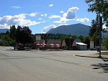
Services
Nakusp has a recreational centre that consists of an ice rink, squash court, curling rink and an auditorium as well as outdoor tennis courts and a soccer field around a five-hectare park. Arrow Lakes Hospital serves the village and surrounding communities. There is an elementary school, a high school, and a campus of Selkirk College. The schools are part of School District 10 Arrow Lakes which has its board office in Nakusp. The area also provides many opportunities for recreation, including the Summit Lake Ski Hill, a short drive out of town towards New Denver.
Culture
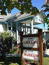
Nakusp is home to a community radio station, CJHQ-FM, and a small library and museum containing numerous local historical artifacts of the indigenous and settler communities of the region.[7]
In 2004 the village held its first Nakusp Music Fest, which proved to be a popular attraction. It was known as the Interior's largest classic rock festival, although classic rock isn't the only genre being played. The Nakusp Music Festival is no longer running, coming to an end in 2011.
Notable people
Brad Larsen is a professional ice hockey left winger who played several seasons in the National Hockey League.
Climate
| Climate data for Nakusp | |||||||||||||
|---|---|---|---|---|---|---|---|---|---|---|---|---|---|
| Month | Jan | Feb | Mar | Apr | May | Jun | Jul | Aug | Sep | Oct | Nov | Dec | Year |
| Record high °C (°F) | 13.3 (55.9) |
13 (55) |
17.5 (63.5) |
24.4 (75.9) |
33 (91) |
35.5 (95.9) |
37.9 (100.2) |
37.6 (99.7) |
33.3 (91.9) |
23 (73) |
18.3 (64.9) |
14.5 (58.1) |
37.9 (100.2) |
| Average high °C (°F) | 0.8 (33.4) |
2.3 (36.1) |
8 (46) |
13.2 (55.8) |
18.8 (65.8) |
22.5 (72.5) |
25.2 (77.4) |
25.1 (77.2) |
18.4 (65.1) |
11.2 (52.2) |
4.6 (40.3) |
−0.1 (31.8) |
12.5 (54.5) |
| Daily mean °C (°F) | −1.7 (28.9) |
−1 (30) |
3.2 (37.8) |
7.5 (45.5) |
12.4 (54.3) |
16.2 (61.2) |
18.3 (64.9) |
18.1 (64.6) |
12.4 (54.3) |
7 (45) |
1.9 (35.4) |
−2.3 (27.9) |
7.7 (45.9) |
| Average low °C (°F) | −4.2 (24.4) |
−4.2 (24.4) |
−1.7 (28.9) |
1.8 (35.2) |
6 (43) |
9.8 (49.6) |
11.4 (52.5) |
11.1 (52) |
6.3 (43.3) |
2.7 (36.9) |
−0.8 (30.6) |
−4.5 (23.9) |
2.8 (37) |
| Record low °C (°F) | −24.4 (−11.9) |
−24.4 (−11.9) |
−18.9 (−2) |
−9.4 (15.1) |
−3.9 (25) |
−1.1 (30) |
1.7 (35.1) |
0.6 (33.1) |
−6.5 (20.3) |
−11 (12) |
−20 (−4) |
−27.8 (−18) |
−27.8 (−18) |
| Average precipitation mm (inches) | 105.5 (4.154) |
74.7 (2.941) |
47.9 (1.886) |
59.8 (2.354) |
60.7 (2.39) |
88.2 (3.472) |
65 (2.56) |
60.4 (2.378) |
57.7 (2.272) |
59.4 (2.339) |
99.5 (3.917) |
86.9 (3.421) |
865.7 (34.083) |
| Average rainfall mm (inches) | 40 (1.57) |
49.7 (1.957) |
44.1 (1.736) |
59.5 (2.343) |
60.7 (2.39) |
88.2 (3.472) |
65 (2.56) |
60.4 (2.378) |
57.7 (2.272) |
58.8 (2.315) |
78.3 (3.083) |
35.5 (1.398) |
698.1 (27.484) |
| Average snowfall cm (inches) | 65.4 (25.75) |
24.9 (9.8) |
3.8 (1.5) |
0.3 (0.12) |
0 (0) |
0 (0) |
0 (0) |
0 (0) |
0 (0) |
0.6 (0.24) |
21.2 (8.35) |
51.4 (20.24) |
167.7 (66.02) |
| Source: [8] | |||||||||||||
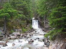
Gallery
|


See also
References
- ↑ "British Columbia Regional Districts, Municipalities, Corporate Name, Date of Incorporation and Postal Address" (XLS). British Columbia Ministry of Communities, Sport and Cultural Development. Retrieved November 2, 2014.
- ↑ Statistics Canada - 2011 Census.
- ↑ Pryce, Paula. Keeping the Lakes Way, University of Toronto Press, 1999, p154, quoted Verne Ray, James Teit
- ↑ http://www.nakusp.com/siteengine/activepage.asp?PageID=3 Village of Nakusp History
- ↑ Wilson, J.W. (1973). People in the Way. Toronto, ON: University of Toronto Press.
- ↑ http://www.nakusp.com Village of Nakusp History
- ↑ http://www.nakusp.com Community Info
- ↑ "Calculation Information for 1981 to 2010 Canadian Normals Data". Environment Canada. Retrieved July 9, 2013.
External links
- Village of Nakusp
- Nakusp Hot Springs
- Halcyon Hot Springs
- Nakusp & District Chamber of Commerce and Visitor Centre
| Subdivisions |  | |
|---|---|---|
| Communities | ||
| Metro areas and agglomerations | ||
| Villages |
| |
| ||
Coordinates: 50°14′36.1″N 117°48′00.6″W / 50.243361°N 117.800167°W