Yarkon River
| Yarkon River | |
| River | |
 | |
| Country | Israel |
|---|---|
| Cities | Tel Aviv, Petah Tikva, Rosh HaAyin |
| Source | Tel Afek |
| - location | near Rosh Ha'ayin, Central District, Israel |
| Mouth | Mediterranean Sea |
| - location | Tel Aviv, Tel Aviv District, Israel |
| - coordinates | 32°5′45″N 34°46′48″E / 32.09583°N 34.78000°ECoordinates: 32°5′45″N 34°46′48″E / 32.09583°N 34.78000°E |
| Length | 27.5 km (17 mi) |
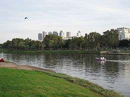
The Yarkon River, also Yarqon River (Hebrew: נחל הירקון, Nahal HaYarkon; Arabic: نهر العوجا, Nahr al-Auja), is a river in central Israel. The source of the Yarkon ("Greenish" in Hebrew) is at Tel Afek (Antipatris), north of Petah Tikva. It flows west through Gush Dan and Tel Aviv's Yarkon Park into the Mediterranean Sea. Its Arabic name, al-Auja, means "the meandering". The Yarkon is the largest coastal river in Israel, at 27.5 km in length.[1]
History
The Yarkon formed the southern border of the vilayet of Beirut during the late Ottoman period.[1]
The Arabic name of the river, al-Auja ("the meandering one"), is shared with another small stream that flows into the Jordan Valley north of Jericho. During World War I this coincidence led to the term of "the line of the two Aujas" referring to a strategic line connecting the two river valleys and taken by the expeditionary forces of General Allenby during his early 1918 advance against the Ottoman army.[2]
In the Mandatory period, the British government granted to Pinhas Rutenberg's Jaffa Electric Company exclusive rights to generate, distribute, and sell electricity in the District of Jaffa. These rights were delivered through the “Auja Concession”, which was formally signed on September 12, 1921. The Concession had authorized the company to generate electricity by means of hydroelectric turbines that would exploit the water power of the Yarkon River to supply electricity to the administrative District of Jaffa. The district comprised Jaffa, the oldest and at the time still most important town in the area, the fast growing town of Tel Aviv north of it, and other smaller locations. Yet the plan to generate electricity by hydroelectric means never materialized, and instead the company designed and built a powerhouse that produced electricity by means of diesel-fueled engines.[3]
The river became increasingly polluted after the 1950s, many blaming this on the construction of the Reading Power Station which is situated near its mouth.
When the river's headwaters were diverted to the Negev via the National Water Carrier for irrigation purposes, the state of the Yarkon declined. As sewage replaced the flow of fresh water, habitats were destroyed and flora and fauna disappeared. This was exacerbated by continuous discharges of industrial effluents and municipal sewage into the rivers, which allowed algae to multiply.[4] On July 14, 1997, the infamous Maccabiah bridge collapse led to the death of four athletes, three of which died due to infections caused by exposure to the polluted river water.[5] Subsequent and ongoing cleanup projects, some government-run, some benefitting from financial aid from Jewish donors from Australia, and some with regional character supported by the NGO FoEME, helped improve the quality of the water.[6][7][8][9]
.jpg) Average Monthly Discharge (1969–1975)
Average Monthly Discharge (1969–1975).jpg) Average Annual Discharge (1969–1975)
Average Annual Discharge (1969–1975)
Yarkon River Authority
In 1988, the Yarkon River Authority was established to revitalize the river and make sections of it suitable for sailing, fishing, swimming and other recreation. Water quality improved after the construction of modern sewage treatment plants in Hod Hasharon and Ramat Hasharon. The river was dredged to restore its original depth and natural flow. River banks were raised and reinforced, hiking and bicycling paths were built, and picnic and fishing areas were developed with the help of contributions from the Australian Jewish community via the Jewish National Fund.[4]
Maccabiah disaster
On July 14, 1997, four members of the Australian delegation to the Maccabiah Games were killed and 60 injured as a result of the collapse of a temporary pedestrian bridge over the Yarkon. The deaths were eventually traced to a fungal infection caused by aspiration of the heavily polluted water.[10]
See also
- Ayalon River, turned artificially into a tributary of the Yarkon
References
- 1 2 Weldon C. Matthews (2006) Confronting an Empire, Constructing a Nation: Arab Nationalists and Popular Politics in Mandate Palestine I.B.Tauris, ISBN 1-84511-173-7 p 26
- ↑ H. S. Gullett (1923). The Australian Imperial Force in Sinai and Palestine, 1914-1918. Sydney: Angus & Robertson Ltd. pp. 487, 542. Retrieved 16 September 2015.
Allenby did not hesitate. His original objective had been the "line of the two Aujas" from the Nahr Auja, which falls into the Mediterranean above Jaffa, to the Wady Auja, a little stream which, bursting from springs in the desert foot-hills above the Jordan valley, flows eastwards to the Jordan River about ten miles north of the Dead Sea.
- ↑ Shamir, Ronen (2013). Current Flow: The Electrification of Palestine. Stanford: Stanford University Press.
- 1 2 A rural walk through the big cities, Jerusalem Post
- ↑ Trounson, Rebecca (August 9, 1997). "Bridge Collapse Casts Light on Israel's Troubled Waters" (Newspaper article). Los Angeles Times. Retrieved 26 March 2009.
- ↑ Keren Kayemeth LeIsrael–Jewish National Fund, The Wetland Project Revives Yarkon River, January 07, 2009
- ↑ EcoPeace Middle East (formerly Friends of the Earth Middle East), Good Water Neighbors - Cross Border Meetings throughout the Region, September 2015
- ↑ KKL-JNF staff,Cornerstone Laid for Bird-Watching Center in Yarkon Park, 26 December 2013
- ↑ WATEC Israel 2015 Conference, Yarkon River Rehabilitation Project
- ↑ Jewish Virtual Library Maccabiah Games
External links
| Wikimedia Commons has media related to Yarkon River. |
- Yarkon River Authority (Hebrew)
- Yarkon River Authority (English)