Nadi
| Nadi | |
|---|---|
|
Nadi | |
| Coordinates: 17°48′00″S 177°25′00″E / 17.80000°S 177.41667°ECoordinates: 17°48′00″S 177°25′00″E / 17.80000°S 177.41667°E | |
| Country |
|
| Island | Viti Levu |
| Division | Western Division |
| Population (2007) | |
| • Total | 42,284 |
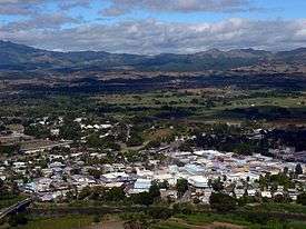
Nadi (pronounced [ˈnandi]) is the third-largest conurbation in Fiji. It is located on the western side of the main island of Viti Levu, and had a population of 42,284 at the most recent census, in 2007. A 2012 estimate showed that the population had grown to over 50,000. Nadi is multiracial with many of its inhabitants Indian or Fijian, along with a large transient population of foreign tourists. Along with sugar cane production, tourism is a mainstay of the local economy.
With its large Indo-Fijian population, Nadi is a centre for Hinduism and Islam in Fiji. The downtown area is defined by the Nadi River and Viseisei village on the west side, and the Sri Siva Subramaniya temple on the east. It is the largest Hindu temple in the Southern hemisphere, and is a site for pilgrims. Nadi International Airport located 9 kilometres from the town, is the largest airport in Fiji. Thus, Nadi is the principal port of entry for air travellers to Fiji, even though it is on the opposite (western) side of the island of Viti Levu from the nation's capital and largest city, Suva.
History

Nadi Township was established in 1947. Around that time the colonial government of Fiji established offices on the higher grounds of Nadi. A few businesses were then established around the government offices to service them, and other business organisations from other parts of Fiji followed suit. Some concerned citizens of Nadi attempted to move the town centre to Martintar because the existing centre was prone to flooding, but this did not eventuate because the move Nadi Township had already developed strong roots in its existing location.
Elective local government was introduced in 1967. Dr A. H. Sahu Khan was the first elected Chairman of the Nadi Township Board.[1] With the introduction of the Local Government Act in 1972, the status of the Board was changed to a Town Council. H. M. Lodhia became the first Mayor of Nadi in 1972 and remained in office until December 1973. The most recent Mayor of Nadi was Councillor S. Sami. At present, elected municipal government in Nadi (and also throughout Fiji) is suspended, and government-appointed Administrators are carrying out the functions normally fulfilled by the City Council.
Government and infrastructure
The Civil Aviation Authority of Fiji (CAAFI) head office is at Nadi Airport in Nadi.[2]
Economy
Fiji Airways, formerly Air Pacific has its head office at the Air Pacific Maintenance & Administration Centre at Nadi International Airport in Nadi.[3][4] Fiji Airlines Limited, operating as Pacific Sun, is headquartered in the Pacific Sun building in the Civil Aviation Authority of Fiji (CAAFI) compound at Nadi International Airport.[5]
Climate
| Climate data for Nadi, Fiji (1961–1990) | |||||||||||||
|---|---|---|---|---|---|---|---|---|---|---|---|---|---|
| Month | Jan | Feb | Mar | Apr | May | Jun | Jul | Aug | Sep | Oct | Nov | Dec | Year |
| Record high °C (°F) | 36.7 (98.1) |
35.4 (95.7) |
35.0 (95) |
34.3 (93.7) |
33.9 (93) |
33.5 (92.3) |
32.9 (91.2) |
34.3 (93.7) |
34.0 (93.2) |
34.6 (94.3) |
36.3 (97.3) |
35.9 (96.6) |
36.7 (98.1) |
| Average high °C (°F) | 31.6 (88.9) |
31.5 (88.7) |
31.1 (88) |
30.7 (87.3) |
29.7 (85.5) |
29.2 (84.6) |
28.5 (83.3) |
28.7 (83.7) |
29.4 (84.9) |
30.2 (86.4) |
30.9 (87.6) |
31.4 (88.5) |
30.2 (86.4) |
| Daily mean °C (°F) | 27.1 (80.8) |
27.2 (81) |
26.9 (80.4) |
26.2 (79.2) |
24.9 (76.8) |
24.2 (75.6) |
23.4 (74.1) |
23.6 (74.5) |
24.4 (75.9) |
25.3 (77.5) |
26.2 (79.2) |
26.7 (80.1) |
25.5 (77.9) |
| Average low °C (°F) | 22.7 (72.9) |
22.9 (73.2) |
22.6 (72.7) |
21.7 (71.1) |
20.1 (68.2) |
19.3 (66.7) |
18.3 (64.9) |
18.4 (65.1) |
19.3 (66.7) |
20.4 (68.7) |
21.5 (70.7) |
22.1 (71.8) |
20.8 (69.4) |
| Record low °C (°F) | 19.0 (66.2) |
18.3 (64.9) |
17.7 (63.9) |
16.2 (61.2) |
14.0 (57.2) |
13.6 (56.5) |
11.7 (53.1) |
11.3 (52.3) |
13.3 (55.9) |
14.4 (57.9) |
15.1 (59.2) |
17.2 (63) |
11.3 (52.3) |
| Average rainfall mm (inches) | 300 (11.81) |
303 (11.93) |
324 (12.76) |
173 (6.81) |
80 (3.15) |
62 (2.44) |
47 (1.85) |
59 (2.32) |
77 (3.03) |
103 (4.06) |
139 (5.47) |
159 (6.26) |
1,826 (71.89) |
| Average rainy days (≥ 1.0 mm) | 14 | 15 | 16 | 9 | 6 | 5 | 4 | 4 | 5 | 7 | 9 | 11 | 105 |
| Average relative humidity (%) | 81 | 82 | 84 | 82 | 80 | 79 | 76 | 75 | 74 | 75 | 76 | 78 | 78 |
| Mean monthly sunshine hours | 213.5 | 182.4 | 190.1 | 197.8 | 212.0 | 206.0 | 218.1 | 231.0 | 214.6 | 226.6 | 221.5 | 225.4 | 2,539 |
| Source #1: NOAA[6] | |||||||||||||
| Source #2: Deutscher Wetterdienst (precipitation days, 1968–1990 and humidity, 1962–1990)[7] | |||||||||||||
References
- ↑ Nadi Town Council – History
- ↑ "Contact Details." Civil Aviation Authority of Fiji. Retrieved on 13 December 2011. "Postal address Private Mail Bag NAP 0354 Nadi Airport Fiji Islands"
- ↑ "Air Pacific Annual Report 2008." Air Pacific. 44 (44/48). Retrieved on 3 October 2009.
- ↑ "Membership." International Air Transport Association. Retrieved on 13 December 2011. "Air Pacific Limited Air Pacific Maintenance & Administration Centre, Nasoso Road Nadi Airport, Nadi Fiji"
- ↑ "Contact Us." Fiji Airlines Limited. Retrieved on 3 October 2009. "Fiji Airlines Limited, trading as Pacific Sun, was incorporated as a wholly owned subsidiary of Air Pacific Limited currently having its main base at the Pacific Sun office, CAAFI Compound, Nadi Airport, Fiji Islands." and "Head Office Pacific Sun PO Box 9270 Nadi International Airport Fiji Islands"
- ↑ "Nandi Climate Normals 1961–1990". National Oceanic and Atmospheric Administration. Retrieved 24 March 2015.
- ↑ "Klimatafel von Nandi (Int. Flugh.) / Viti Levu / Fidschi" (PDF). Baseline climate means (1961-1990) from stations all over the world (in German). Deutscher Wetterdienst. Retrieved 22 November 2016.
- Nadi Town Fiji Restaurant
- Indian Asian Denarau Nadi Fiji Restaurant
- Seafood Fiji Restaurant in Denarau, Nadi
External links
| Wikivoyage has a travel guide for Nadi. |
| Wikimedia Commons has media related to Nadi. |