Mysłowice
| Mysłowice | ||
|---|---|---|
|
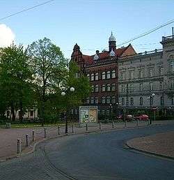
Freedom Square | ||
| ||
 Mysłowice | ||
| Coordinates: 50°14′N 19°8′E / 50.233°N 19.133°E | ||
| Country |
| |
| Voivodeship |
| |
| County | city county | |
| Established | 14th century | |
| Town rights | 1360 | |
| Government | ||
| • Mayor | Edward Lasok | |
| Area | ||
| • City | 65.75 km2 (25.39 sq mi) | |
| Population (2013) | ||
| • City | 75,428 | |
| • Density | 1,100/km2 (3,000/sq mi) | |
| • Urban | 2,746,000 | |
| • Metro | 4,620,624 | |
| Time zone | CET (UTC+1) | |
| • Summer (DST) | CEST (UTC+2) | |
| Postal code | 41-400 to 41-412 | |
| Area code(s) | +48 32 | |
| Car plates | SM | |
| Website | http://www.myslowice.pl | |

Mysłowice [mɨswɔˈvʲit͡sɛ] (German Myslowitz) is a city in Silesia in southern Poland, near Katowice. The population of the city as of 2008 is 74,912.[1]
It is located in the south district of the Upper Silesian Metropolitan Union in the Silesian Highlands, on the Przemsza and Brynica rivers (tributaries of the Vistula). It is situated in the Silesian Voivodeship since its formation in 1999, previously in the Katowice Voivodeship, and before then, the Autonomous Silesian Voivodeship. Mysłowice is one of the cities comprising the 2.7 million conurbation - Katowice urban area and within the greater Silesian metropolitan area with a population of about 5,294,000.[2]
History
Mysłowice is one of the oldest towns in Upper Silesia. Located at the confluence of the White and Black Przemsza rivers, it is situated on an important trading route from Wrocław to Kraków. The earliest traces of the modern settlement date back to the 12th and 13th century. The first mention of a parish priest is found in a document from 1306. In 1360, Mysłowice was already referred to as a town.
Over the centuries the ownership of the town changed frequently, as did the borders between different countries. After the foundation of the German Empire in 1871 the area became known as Dreikaisereck ("triangle of the three emperors"), as it was situated at the point where the Austrian, German and Russian Empires adjoined. After World War I and a plebiscite in 1922 Mysłowice and a part of Upper Silesia became part of the newly restored Poland.
Districts
Mysłowice is subdivided into 14 districts:[3]
- Bończyk–Tuwima
- Brzezinka
- Brzęczkowice and Słupna
- Dziećkowice
- Janów Miejski–Ćmok
- Kosztowy
- Krasowy
- Larysz–Hajdowizna
- Morgi
- Mysłowice Centrum
- Piasek
- Stare Miasto
- Szopena–Wielka Skotnica
- Wesoła
Education
Mysłowice is home to a university-level institution called Górnośląska Wyższa Szkoła Pedagogiczna im. Kard. Augusta Hlonda (August Hlond College of Pedagogy) located at ul. Piastów Śląskich 10.
Mysłowice has eight Junior High Schools and five Secondary and vocational schools. There are at least 20 kindergartens located in Mysłowice, residing at location with greater density of children. On top of that, there are also 17 primary schools operating in the city.
Monuments
There are some buildings in Mysłowice which prove the medieval origin of the town. Farna Church, located near the market square, is the oldest and probably the only brick church in Mysłowice. Saint Cross Church is another brick building, maintained in baroque and classicistic style; according to Catholic tradition, it is the oldest place of religious worship in the town. There is also a Jewish cemetery in the town. The origins of the place trace back to the 18th century, when Jews decided to buy a tract in order to create their own graveyard.
Culture
The Off Festival is an annual music festival started in 2006 by musician Artur Rojek (however, in 2010 it was moved to Katowice[4]). Bands from Mysłowice include Myslovitz formed 1992 (named after their hometown), as well as Lenny Valentino (1998–2001).
Notable residents
- Georg Koßmala (1896-1945), Wehrmacht general
- Albert Norden (1904-1982), East German politician
International relations
Twin towns — Sister cities
Mysłowice is twinned with these cities:[5]
 Enzkreis in Germany[5]
 Sokola Góra in Poland[5]
 Frýdek-Místek in the Czech Republic[5]
References
- ↑ Powierzchnia i ludność w przekroju terytorialnym w 2008 - Central Statistical Office in Poland ISSN 1505-5507 , 13.08.2008
- ↑ European Spatial Planning Observation Network (ESPON)
- ↑ "Jednostki pomocnicze" (in Polish). BIP Miasta Mysłowice. Retrieved 2015-05-08.
- ↑ "Rojek zabiera festiwal z Mysłowic". Tvn24.pl. 2010-02-25. Retrieved 2013-03-26.
- 1 2 3 4 Mysłowiceown Council (2011). "Mysłowice Partner Towns". myslowice.pl. Retrieved 17 May 2011.
External links
![]() Media related to Mysłowice at Wikimedia Commons
Media related to Mysłowice at Wikimedia Commons
- http://www.myslowice.pl Official site of Mysłowice
- http://m-ce.net Site of Mysłowice
- http://www.m-ce.pl The Website of Myslowice (Polish, some content in English)
- Jewish Community in Mysłowice on Virtual Shtetl
- http://www.myslowice.zobacz.slask.pl Myslowice, Silesia (Polish, some content in English)
| City counties |  | |
|---|---|---|
| Land counties | ||
Coordinates: 50°14′N 19°08′E / 50.233°N 19.133°E