Myaungmya Township
| Myaungmya Township မြောင်းမြမြို့နယ် | |
|---|---|
| Township | |
| Coordinates: 16°35′N 94°54′E / 16.583°N 94.900°E | |
| Country |
|
| Division | Ayeyarwady Region |
| District | Myaungmya District |
| Time zone | MST (UTC+6:30) |
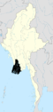
Myaungmya Township (Burmese: မြောင်းမြမြို့နယ် [mjáʊɴmja̰ mjo̰nɛ̀]) is a township of Myaungmya District in the Ayeyarwady Region of Myanmar. The seat lies at Myaungmya.
It was formed in 1893 out of a portion of Bassein district, and reconstituted until 1903. It has an area of 2663 m²., and population of 278,119, showing an increase of 49% in the decade and a density of 104 inhabitants to the square mile. Among the population were about 12,800 Christians, mostly Karens. The district is a deltaic tract, bordering south on the sea and traversed by many tidal creeks. Rice cultivation and fishing occupy practically all the inhabitants of the district.
See also
Capital: | |
|
This article is issued from Wikipedia - version of the 1/20/2016. The text is available under the Creative Commons Attribution/Share Alike but additional terms may apply for the media files.