Muthupet
| Muthupet முத்துப்பேட்டை | |
|---|---|
| City | |
|
A view of the lagoon and the ocean beyond | |
 Muthupet Location in Tamil Nadu, India | |
| Coordinates: 10°24′N 79°30′E / 10.4°N 79.5°ECoordinates: 10°24′N 79°30′E / 10.4°N 79.5°E | |
| Country |
|
| State | Tamil Nadu |
| District | Thiruvarur |
| Government | |
| • Chairman | Arunachalam All India Anna Dravida Munnetra Kazhagam |
| Population (2011) | |
| • Total | 40,000 |
| Languages | |
| • Official | Tamil |
| Time zone | IST (UTC+5:30) |
| PIN | 614704 |
| Telephone code | 91 4369 |
| Vehicle registration | TN 51 |

Muthupet is a panchayat town in Thiruvarur district in the Indian state of Tamil Nadu.
Demographics
As of 2011 India census,[1] Muthupet had a population of 40,000. Males constitute 47% of the population and females 53%. Muthupet has an average literacy rate of 71%, higher than the national average of 59.5%: male literacy is 78%, and female literacy is 65%.
Geography
Muthupet is a town in Tiruvarur District. It is located between Thirutturaipoondi and Pattukkotai, and around 360 km away from Chennai. The town lies adjacent to the Bay of Bengal and is in the southernmost part of the Cauvery delta. Muthupet is bounded by Korayar and Bamaniyar rivers to the east and west respectively. The rivers Koriayar and Pamaniyar join near Muthupet, and there is a lagoon, which is rich in fish.
Muthupet is an ideal place for fishing, pearl hunting and bird hunting. It is well known for its fishing industries such as finfish (koduva), shrimp and crab. A natural mangrove forest, Alayathi Kadu, is one of the largest of its kind in India.
Muthupet mangroves and lagoon

Muthupet mangrove forest is located at the southern end of the Cauvery delta, covering an area of approximately 13,500 ha of which only 4% is occupied by well-grown mangroves. The rivers Paminiyar, Koraiyar, Kilaithankiyar, Marakkakoraiyar and other tributaries of the river Cauvery flow through Muthupet and adjacent villages. At the tail end, they form a lagoon before meeting the sea.
The northern and western borders of the lagoon are occupied by muddy silt ground which is devoid of mangroves. The mangroves beyond Muthupet Lagoon are discontinuously found along the shore and extended up to Point Calimere. Muthupet mangrove forest was under the control of Chatram Department from 1853 to 1912 (Chengappa, 1918). The government of the presidency of Madras Gazette (1937) shows, from 1923 to 1936, half of the revenue obtained from selling mangrove products was paid to the revenue department and the remaining half was spent to maintain the “Chatrams” (Charity homes). The government declared the Muthupet mangrove forest as revenue forest in February 1937 and, accordingly, the mangrove forest was handed over to the forest department of the Madras presidency.
The forest is maintained by the Tamil Nadu Forest Department. The mangrove forest is divided into the Palanjur, Thamarankottai, Maravakkadu, Vadakadu, Thuraikadu and Muthupet reserve forests.
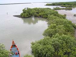
Muthupet reserve forest covers the lagoon, river creeks and the mudflats. Muthupet Lagoon (mullipallam) is a spectacular natural creation, which is 8 km from nearby Muthupet town and can be reached only by boat. The lagoon is shallow with an average depth of 1 m. The bottom of the lagoon is formed of silt clay substratum. The tidal fluctuations can be observed well with the exposure of oyster beds and roots during low tide.
The tidal fluctuations play a major role in dispersing mangrove seeds. Dense mangroves mostly cover the lagoon shore. The islets are found on western side which are submerged during high tide. The salinity is the major environmental factor, controlling zonation of Muthupet mangrove forest. Avicennia marina is the conqueror of the forest which is found as a single dominant species.
The southern mudflat separates the lagoon from the adjacent sea that leaves a permanent mouth of lagoon with seasonally opened shallow waterways. The width of mudflat is increased from lagoon mouth to the eastern direction. The mudflat looks like a desert in summer, but the presence of dead gastropods under the surface soil layer and the erosion of soil at the centre of mudflat reveal the submergence of mudflat during flood. There is a difference between the lagoon shore and seashore of the same mudflat, in the aspect of distance of mangroves from fluctuating water level.

The mangroves have grown close to water level in lagoon side but not in seashore. The reason may be the difference in the nature of fine clayey silt deposition that carried by the rivers. The salt marshes are found as under herb as well as lining the inner side of the forest. In the degraded central part of the mudflat, the soft fine silt is found only around the salt marshes. The remaining barren ground is hard clay which may due to the erosion of surface silt by wind or floodwater. Thousands of partially decomposed rooted trunks found on the southeastern side of Muthupet lagoon are indicating the past, indiscriminate exploitation.

At 100–150 m in width and 5–6 km in length, the density of mangroves in eastern side of Muthupet lagoon is comparatively lower than other areas. Tamil Nadu Forest Department has excavated several canals across the mudflat. Each main canal, which enhances the water movement between sea and lagoon, has several subcanals on either side with a substantial number of mangrove seedlings. The western side has a protruding land pocket has formed an islet-like structure. This part of the lagoon lies near Koraiyar river mouth with small mangrove patches.
Industry
Muthupet is famous for its coconut and fishing as well as Aqua Farms. The ancient occupation of the people is fishing.123456
Muthupet Dargah
The 700-year-old Islamic shrine here has glorious aspects and a traditional background. This dargah, Andavar Sheikh Dawood Khamil Oliyullh, was built using traditional architecture. People irrespective of caste, creed and religion visit this holy Dargah. Maximum number of visitors are from Kerala and Karnataka. Some of the international peoples from Pakistan, Bangladesh, Sri Lanka, Malaysia etc., are also attend the main functions.
Transport
Muthupet Railway Station is on the Karaikkudi-Tiruthuraipoondi line. As this section of the railway track is currently undergoing gauge conversion, there are no direct trains from Chennai to Muthupet.
This town is well connected via road and rail with major towns and cities in Tamil Nadu. The East Coast Road (ECR) from Chennai to Kanyakumari connects this town as well. Frequent bus services are available to the nearby town, Pattukkottai. There are 11 Private omni buses runs daily night services for passengers as well as freight to Chennai in addition with the state owned TNSTC regular passenger services.
The East Coast Road (ECR) from Chennai to Kanyakumari connects this town as well.
Tiruchirapalli is the nearest international airport and is located around 112 km from Muthupet.
Distance from major cities / towns via rail
| City | Distance (in km) |
|---|---|
| Chennai | 371 |
| Mumbai | 1655 |
| Bangalore | 444 |
| New Delhi | 2561 |
| Karaikudi | 90 |
| Mayiladuthurai | 90 |
| Thiruvarur | 50 |
Distance via road
| City | Distance (in km) |
|---|---|
| Adirampattinam | 15 |
| Thiruthuraipoondi | 25 |
| Tiruchirappalli | 112 |
| Chennai | 348 |
| Kumbakonam | 70 |
| Mannargudi | 34 |
| Madurai | 165 |
| Kilakarai | 160 |
| Kayalpattinam | 302 |
Auto rickshaws act as major mode of private transportation for short distance travels. For long travels, people prefer private run taxis.
Daily bus trips from Muthupet to Chennai
- MJT Semi Sleeper (via Pattukkottai)
- MJT (via ECR Road)
- SVT Semi Sleeper
- RathiMeena (Semi Sleeper)
- SRM (A/C coach)
- Universal (multi Volvo A/C Coach) (via ECR)
- Universal (Berth Sleeper) (via ECR)
- Raahath Semi Sleeper(via ECR)
- Rahmath Semi Sleeper (Via ECR)
- TNSTC (Super Deluxe)(via Mannargudi, Kumbakonam)
- SETC (Ultra Deluxe) (Via Thiruthuraipoondi, Puducherry)
Infrastructure
The Muthupet bazaar is a busy bazaar which serves not only the town, but also its suburban villages. Muthupet having two biggest fish markets in the town, which serves the surrounding regions of other districts also.
It houses a government hospital along with enough number of private hospitals/clinics. The Muthupet police station serves the town as well as the surrounding villages. Government establishments like the post office, the Sub-registrar office, the Municipality office, the Village Panchayat office, the Tamil Nadu Forest Department, the Customs Preventive Unit and the Government library have their base in the town.
Muthupet has four Petrol bunks which sell petrol, diesel and oil to the public. Muthupet has a good mobile phone network as well. Operators like BSNL, Airtel, Vodafone, MTS, TATA, TATA DOCOMO, Videocon, Aircel and Reliance provide their services. BSNL also provides land line phones and Broadband internet connection to its subscribers. In addition, wireless WI-FI connection named Med WI-FI given by the med group and the town also has sufficient number of internet browsing cafes.
Education
Muthupet has commendable number of educational institutions for higher studies. Name of the some institutions are,
- Govt Boys Higher Secondary School, Mannai Salai
- perianayaki Govt Girls higher secondary school muthupet
- Govt Middle School, Pettai
- Rahmath Girls Matriculation Higher Secondary School, Abdul Kasim Nagar http://www.rgmhss.com/
- Brilliant Matriculation Higher Secondary School, Ecr-Pkt Road
- A.N (SANGATH) Primary School
- O.M.A School, O.M.A Garden, Jambavanodai, Melakadu http://www.omaschool.in/
- Al'Maha Primary School, New Busstand
- KAP Girls Higher Secondary School, Mannai Salai
- New Street Govt Primary School, Old Busstand
- Saraswathi Vidhyalaya Matriculation Higher Secondary School, Ecr-Mannai Salai
- Winners Matriculation School, Alangadu.
Banks and ATMs
- State Bank of India with ATM (1) (Mannai Salai)
- Canara Bank with ATM (1) (Near Koyyah Mahal)
- Icici Bank with ATM (1) (TTP Road)
- Indian Overseas Bank with ATM (2) (New street)
- Indian Bank with ATM (1) (Near old bus stand)
- Lakshmi Vilas Bank with ATM (1) (Near Old post office road)
- Bank of India ATM (1) ( PKT Road near Sekkadi kulam)
- Kumbakonam Bank (Mannai Salai near Railway line)
- coming soon Axis Bank near Bangalow vasal. (PKT road)
- coming soon City union Bank Searching the Places for Muthupet Town.
References
- ↑ "Census of India 2001: Data from the 2001 Census, including cities, villages and towns (Provisional)". Census Commission of India. Archived from the original on 2004-06-16. Retrieved 2008-11-01.
External links
| Wikimedia Commons has media related to Muthupet. |